|
تضامنًا مع حق الشعب الفلسطيني |
ملف:Tour of the Galapagos.ogv
اذهب إلى التنقل
اذهب إلى البحث
ملحق معالج الوسائط لتنسيق الملف هذا مفقود. قد لا تعمل ميزات الوسائط المتقدمة ما لم يتم عرض الملف [ https://commons.wikimedia.org/wiki/File:Tour_of_the_Galapagos.ogv عند المستودع المشترك ].

حجم هذه المعاينة: 800 × 450 بكسل. الأبعاد الأخرى: 320 × 180 بكسل | 640 × 360 بكسل | 1٬280 × 720 بكسل.
الملف الأصلي (حجم الملف: 33٫33 ميجابايت، نوع MIME: application/ogg)
| هذا ملف من ويكيميديا كومنز. معلومات من صفحة وصفه مبينة في الأسفل. كومنز مستودع ملفات ميديا ذو رخصة حرة. |
ملخص
| الوصف |
English: Straddling the equator approximately 1000 kilometres to the west of the South American mainland, the Galapagos Islands lie within the heart of the equatorial current system. Rising from the sea floor, the volcanic islands of the Galapagos are set on top of a large submarine platform. The main portion of the Galapagos platform is relatively flat and less than 1000 meters in depth. The steepest slopes are found along the western and southern flanks of the platform with a gradual slope towards the east. The interactions of the Galapagos and the oceanic currents create vastly different environmental regimes which not only isolates one part of the Archipelago from the other but allows penguins to live along the equator on the western part of the Archipelago and tropical corals around the islands to the north. The islands are relatively new in geologic terms with the youngest islands in the west still exhibiting periodic eruptions from their massive volcanic craters. |
| التاريخ | |
| المصدر | NASA Earth Observatory |
| المؤلف | Kevin Ward |
Data sets used in the Animation: MODIS True Colour. Landsat 30 Meter True Colour. ETOPO 2 Bathymetry. MODIS Sea Surface Temperature. SeaWiFS Ocean Chlorophyll and Land Vegetation Index. SRTM Topography for Land Elevation.
ترخيص
| يقع هذا العمل في النِّطاق العامّ في الولايات المُتحدة الأمريكيَّة لأَنَّه عملٌ خالِصٌ من إِنتاج وكالة الفضاء الأمريكيَّة. تنصُ حقوق التَّأليف والنَّشر الخاصَّة بوكالة الفضاء الأمريكيَّة على أنَّ "أعمال الوكالة غير مَحميَّة بحقوق التَّأليف والنَّشر ما لم يُذكر خلافُ ذلك". لمزيدٍ من المعلومات انظر القالِب {{PD-USGov}} وصفحة حقوق التَّأليف والنَّشر الخاصَّة بالوكالة وصفحة سياسة الصُّور الخاصَّة بمُختبر الدَّفع النَّفَّاث. | ||
 |
تنبيهات:
|
تاريخ الملف
اضغط على زمن/تاريخ لرؤية الملف كما بدا في هذا الزمن.
| زمن/تاريخ | صورة مصغرة | الأبعاد | مستخدم | تعليق | |
|---|---|---|---|---|---|
| حالي | 13:31، 19 يوليو 2009 | 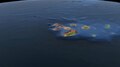 | (33٫33 ميجابايت) | commonswiki>Originalwana | {{Information |Description={{en|1=Straddling the equator approximately 1000 kilometres to the west of the South American mainland, the Galapagos Islands lie within the heart of the equatorial current system. Rising from the sea floor, the volcanic islands |
استخدام الملف
ال1 ملف التالي مكررات لهذا الملف (المزيد من التفاصيل):
- ملف:Tour of the Galapagos.ogv من ويكيميديا كومنز
الصفحة التالية تستخدم هذا الملف: