|
تضامنًا مع حق الشعب الفلسطيني |
ملف:IFR low altitude enroute chart Washington D.C area.tif
اذهب إلى التنقل
اذهب إلى البحث
ملحق معالج الوسائط لتنسيق الملف هذا مفقود. قد لا تعمل ميزات الوسائط المتقدمة ما لم يتم عرض الملف [ https://commons.wikimedia.org/wiki/File:IFR_low_altitude_enroute_chart_Washington_D.C_area.tif عند المستودع المشترك ].

حجم معاينة لذلك الملف ذي الامتداد TIF: 749 × 599 بكسل. الأبعاد الأخرى: 300 × 240 بكسل | 600 × 480 بكسل | 960 × 768 بكسل | 1٬280 × 1٬024 بكسل | 2٬560 × 2٬048 بكسل | 5٬626 × 4٬501 بكسل.
الملف الأصلي (5٬626 × 4٬501 بكسل حجم الملف: 10٫12 ميجابايت، نوع MIME: image/tiff)
| هذا ملف من ويكيميديا كومنز. معلومات من صفحة وصفه مبينة في الأسفل. كومنز مستودع ملفات ميديا ذو رخصة حرة. |
ملخص
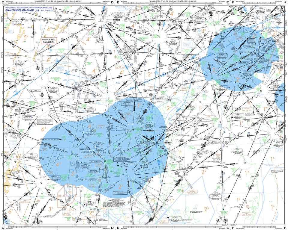
| الوصف | This low altitude section chart is issued for use in air navigation under en:Instrument Flight Rules. The dimensions of this depicted area around Washington D.C. are nearly 280 and 220 nautical miles. |
| التاريخ | |
| المصدر | This is a derivative work originated from a chart package issued by the Federal Aviation Administration. The following changes were made: extracted pages D to F, title strip, "NOT FOR REAL" tag for safety. |
| المؤلف | User:Orion 8 |
ترخيص
This image or file is a work of a Federal Aviation Administration employee, taken or made as part of that person's official duties. As a work of the U.S. federal government, the image is in the public domain in the United States.
|
 |
تاريخ الملف
اضغط على زمن/تاريخ لرؤية الملف كما بدا في هذا الزمن.
| زمن/تاريخ | صورة مصغرة | الأبعاد | مستخدم | تعليق | |
|---|---|---|---|---|---|
| حالي | 01:22، 8 نوفمبر 2013 |  | 5٬626 × 4٬501 (10٫12 ميجابايت) | commonswiki>Orion 8 | {{Information |Description= - |Source= |Date= |Author= |Permission= |other_versions= }} |
استخدام الملف
ال1 ملف التالي مكررات لهذا الملف (المزيد من التفاصيل):
- ملف:IFR low altitude enroute chart Washington D.C area.tif من ويكيميديا كومنز
الصفحة التالية تستخدم هذا الملف: