|
تضامنًا مع حق الشعب الفلسطيني |
عبرنة أسماء الأماكن الفلسطينية


تمت صياغة الأسماء العبرية لأسماء الأماكن في فلسطين عبر فترات مختلفة: تحت الانتداب البريطاني؛ وبعد قيام دولة إسرائيل في أعقاب تهجير الفلسطينيين 1948 ثم حرب 1948. وبعد ذلك في الأراضي الفلسطينية التي احتلتها إسرائيل عام 1967.[2][3] عام 1992، أحصت دراسة نحو 2780 موقعًا تاريخيًا تم عبرنتها، منها 340 قرية وبلدة، و1000 خربة (أطلال)، و560 وادياً ونهراً، و380 ينبوعًا، و198 جبلًا وتلاً، و50 كهفًا، و28 قلعة وقصرًا، و14 بركةً وبحيرةً.[4] يعتبر الفلسطينيون عبرنة أسماء الأماكن في فلسطين جزءًا من النكبة الفلسطينية.[5]
العديد من أسماء الأماكن في فلسطين هي أشكال مُعربة من أسماء الأماكن العبرية والكنعانية القديمة المستخدمة خلال العصور القديمة. يمكن العثور على العديد من الأسماء الأصلية في الكتاب المقدس العبري والتلمود.[6][7] تم تناقل معظم هذه الأسماء منذ آلاف السنين على الرغم من أن معانيها لم يفهمها سوى عدد قليل. خلال العصور القديمة الكلاسيكية والمتأخرة، تحولت أسماء الأماكن القديمة إلى الآرامية واليونانية،[8][9] اللغتين الرئيسيتين اللتين تم التحدث بهما في المنطقة قبل ظهور الإسلام.[9][8][10] بعد الفتح الإسلامي لبلاد الشام، تم تبني أشكال مُعرَّبة للأسماء القديمة.
لقد شجعت الحكومة الإسرائيلية على عبرنة أسماء الأماكن، بهدف تقوية ارتباط اليهود، الذين هاجر معظمهم في العقود الأخيرة.[11] كجزء من هذه العملية، تمت استعادة العديد من أسماء الأماكن القديمة التوراتية أو التلمودية.[12] في حالات أخرى، تم إعطاء أسماء عبرية جديدة للمواقع التي تحتوي على أسماء عربية فقط ولا توجد أسماء عبرية قديمة موجودة مسبقًا.[13][12] في بعض الحالات، تم الحفاظ على اسم المكان العربي الفلسطيني في العبرية الحديثة، على الرغم من وجود تقليد عبراني مختلف فيما يتعلق بالاسم، كما في حالة بانياس، والتي تسمى في الكتابات العبرية الكلاسيكية "پانياس" (Paneas).[14] تشير لافتات التوجيهات البلدية والخرائط التي تنتجها الوكالات الحكومية أحيانًا إلى الاسم العبري التقليدي والاسم العربي التقليدي جنبًا إلى جنب، مثل "نابلس / شكيم" و"سلوان / شيلوح" إلخ.[15] في مناطق معينة من إسرائيل، ولا سيما المدن المختلطة بين اليهود والفلسطينيين، هناك اتجاه متزايد لاستعادة أسماء الشوارع العربية الأصلية التي تم تحويلها إلى العبرية بعد عام 1948.[16][17]
التاريخ المبكر


كان كلود كوندر (1848-1910) من صندوق استكشاف فلسطين من أوائل الذين أدركوا أهمية تحليل أسماء الأماكن العربية الحالية من أجل تحديد الاسم العبري الأقدم للموقع. كانت مساهمة كوندر مهمة من حيث أنه لم يستأصل أسماء الأماكن العربية في مسحه لخرائط فلسطين الغربية، لكنه حافظ على أسمائها كما هي، بدلاً من أن ينسب الموقع إلى تعريف مشكوك فيه.[19] يذكر في مذكراته أن التقاليد العبرية والعربية لأسماء الأماكن غالبًا ما تكون متوافقة مع بعضها البعض:
تظل أسماء المدن والقرى القديمة المذكورة في الكتاب المقدس في معظمها دون تغيير تقريبًا. . . حقيقة أن كل اسم تم تسجيله بعناية بحروف عربية جعل من الممكن مقارنته بالعبرية بطريقة علمية. . . عندما يتبين أن اللغتين العبرية والعربية تحتويان على نفس الجذور، ونفس الكلمات الحلقية، وغالبًا ما تحتويان على نفس المعاني، فإن لدينا مقارنة موثوقة حقًا. . . لقد استعدنا الآن أكثر من ثلاثة أرباع أسماء الكتاب المقدس، وبالتالي يمكننا أن نقول بثقة أن طبوغرافيا الكتاب المقدس هي طبوغرافيا حقيقية وفعلية، وهو عمل العبرانيين المطلعين على البلاد.[20]
أولى جهود العبرنة الحديثة
بدأت جهود العبرنة الحديثة من وقت العليا الأولى عام 1880.[21] في أوائل العشرينيات من القرن الماضي، بدأت حركة شباب هاحالوتس برنامج العبرنة للمستوطنات المنشأة حديثًا في فلسطين الانتدابية.[22] ومع ذلك، تم تطبيق هذه الأسماء فقط على المواقع التي اشتراها الصندوق القومي اليهودي، حيث لم يكن لها أي تأثير على أسماء المواقع الأخرى في فلسطين.
نظرًا لأن علامات الاتجاه كانت تُدرج في كثير من الأحيان باللغة العربية فقط مع ترجماتها الصوتية الإنجليزية (باستثناء الأسماء العبرية المكافئة لها)، حاول المجتمع اليهودي في فلسطين، بقيادة صهاينة بارزين مثل داود يلين، التأثير على عملية التسمية التي بدأتها اللجنة الدائمة للأسماء الجغرافية التابعة للجمعية الجغرافية الملكية،[23][24] وذلك لجعل التسمية أكثر شمولاً.[25] على الرغم من هذه الجهود، إلا أن المدن والأماكن الجغرافية المعروفة، مثل القدس وأريحا ونابلس والخليل ونهر الأردن وغيرها، حملت أسماء بالعبرية والعربية (على سبيل المثال: القدس / أورشليم / والخليل / هبرون)،[26] ولكن المواقع اليهودية الكلاسيكية الأقل شهرة في العصور القديمة (على سبيل المثال الجيش / غوش حالاف؛ بيسان / بيت شيعان؛ شفا عمرو / شفرعم؛ كفر عنان / كفر حنينة؛ بيت جبرين / بيت جبرين ...وغيرها)[27][28][25] كان الاعتراض الرئيسي على إضافة تهجئات إضافية لأسماء المواقع العبرية القديمة هو الخوف من أن يتسبب ذلك في إرباك الخدمة البريدية، عندما يتم إعطاء أسماء معتادة منذ فترة طويلة، وكذلك الاختلاف تمامًا مع الأسماء المسجلة بالفعل على الخرائط. لذلك، سعى المسؤولون البريطانيون إلى ضمان أشكال موحدة لأسماء الأماكن.[29]
أحد العوامل الدافعة وراء قيام أعضاء اليشوف بتطبيق الأسماء العبرية على الأسماء العربية القديمة، على الرغم من محاولات عكس ذلك من قبل لجنة الجمعية الجغرافية الملكية للأسماء،[25] كان اعتقاد الجغرافيين التاريخيين، من اليهود وغير اليهود، بأن العديد من أسماء الأماكن العربية كانت مجرد "فساد" للأسماء العبرية القديمة،[30] (على سبيل المثال خربة شيفات = يودفات؛ خربة تبنة = تمنة؛[31][32] لفتا = نفتوح؛[33] جبل الفريديس = الفريديس وغيرها). في أوقات أخرى، كان تاريخ تخصيص "الاسم العبري المستعاد" لأحد المواقع محفوفًا بالأخطاء والارتباك، كما في حالة عراق المنشية، حيث تقع كريات جات الآن. في البداية، أطلق عليها اسم "تل جت"، بناءً على تعريف أولبرايت للموقع مع جت التوراتي. عندما وجد أنها تسمية خاطئة، تم تغيير الاسم إلى تل العريني، والذي وجد أيضًا أنه تسمية خاطئة لما كان يُعتقد أنه الاسم القديم للموقع.[34]
وفقًا للبروفيسور فرجينيا تيلي، "تم اختراع مجموعة من السلطات العلمية واللغوية والأدبية والتاريخية والإنجيلية لتعزيز الانطباعات عن الانتماء اليهودي والحقوق الطبيعية في وطن يهودي مستمد من حق يهودي خاص في هذه الأرض، والذي من الواضح أنه قد احتلته شعوب كثيرة عبر آلاف السنين".[35]
في وقت مبكر من عام 1920، تم إنشاء لجنة فرعية عبرية من قبل الحكومة البريطانية في فلسطين بهدف تقديم المشورة للحكومة بشأن النسخة الإنجليزية لأسماء المحليات وتحديد شكل الأسماء العبرية للاستخدام الرسمي من قبل الحكومة.[24]
لجنة تسمية الصندوق القومي اليهودي
في عام 1925، أنشأت مديرية الصندوق القومي اليهودي "لجنة أسماء المستوطنات"، بهدف إعطاء أسماء للمستوطنات اليهودية الجديدة المقامة على الأراضي التي اشتراها الصندوق القومي اليهودي.[36] قادها مباشرة رئيس الصندوق القومي اليهودي مناحيم أوسيشكين.[37] المجلس القومي اليهودي، من جانبهم، اجتمع في اجتماع في أواخر عام 1931، من أجل تقديم توصياته للحكومة البريطانية في فلسطين الانتدابية، من خلال اقتراح تعديلات على كتاب نشره المكتب الاستعماري البريطاني في فلسطين الذي حددت فيه مجموعة من المعايير المستخدمة عند الإشارة إلى أسماء الأماكن المترجمة من العربية والعبرية إلى الإنجليزية، أو من العربية إلى العبرية، ومن العبرية إلى العربية، بناءً على أسماء المواقع القديمة للبلاد.[38] تم تنفيذ العديد من المقترحات نفسها التي قدمها المجلس القومي اليهودي في وقت لاحق، بدءًا من عام 1949 (لجنة الأسماء الجغرافية) وبعد ذلك بعد عام 1951، عندما أنشأ يشعياهو برس (عضو في المجلس الوطني اليهودي) لجنة التسمية الوطنية.[39]
كتب ميرون بنفينستي أن الأسماء الجغرافية العربية أزعجت المجتمع اليهودي الجديد على سبيل المثال في 22 أبريل 1941 كتبت لجنة مستوطنات عميق زيفولون إلى المكتب الرئيسي للصندوق القومي اليهودي:[40]
يتم عرض الأسماء التالية بكل مجدها: كرباسة، الشيخ الشمالي، أبو سرقوق، بستان الشمالي - كلها أسماء لا يهتم الصندوق القومي اليهودي بتخليدها في وادي زفولون. . . . نوصيك بإرسال رسالة دورية إلى جميع المستوطنات الواقعة على أراضي الصندوق القومي اليهودي في وادي زفولون ومحيطه المباشر وتحذيرهم من استمرار الممارسة المذكورة أعلاه [أي استخدام] الخرائط القديمة التي، من وجهات نظر مختلفة، تعتبر خطيرة للاستخدام.
بين عامي 1925 و 1948، أعطت لجنة التسمية في الصندوق القومي اليهودي أسماء 215 جالية يهودية في فلسطين.[21] على الرغم من التغييرات الكاسحة التي طرأت على أسماء المواقع الجغرافية القديمة، إلا أنه تم الاحتفاظ بسجل لأسمائها القديمة على الخرائط القديمة.[41]
تفوق اللغة العربية
بحلول عام 1931، كانت القوائم المحددة في مكاتب البريد، واللافتات في محطات القطار وأسماء الأماكن المدرجة في دليل الهاتف، قد أزالت أي ذكر بالعبرية لـ "شكيم" (نابلس) و "الناصرة" و"ناحال سوريك " (وادي الصرار)، الأمر الذي أثار قلق المجلس القومي اليهودي من أن الحكومة البريطانية لفلسطين كانت متحيزة تجاه مواطنيها اليهود.[42] ناحال سوريك، كان طريقاً ومعبراً رئيسيًا في السفر بالقطار من القدس إلى هارتوف.
1949: لجنة تحديد أسماء الأماكن في النقب
في أواخر عام 1949، بعد حرب فلسطين 1947-1949، أنشأت الحكومة الإسرائيلية الجديدة لجنة تعيين أسماء الأماكن في منطقة النقب، وهي مجموعة من تسعة باحثين كانت مهمتهم تحديد الأسماء العبرية للمدن والجبال والوديان والينابيع والطرق وغيرها في منطقة النقب.[43] قرر رئيس الوزراء دافيد بن غوريون أهمية إعادة تسمية المنطقة في وقت سابق من العام، حيث كتب في مذكراته في يوليو: "يجب أن نعطي أسماء عبرية لهذه الأماكن - الأسماء القديمة، إذا كانت موجودة، وإذا لم تكن، نستحدث أخرى جديدة!"؛[44] حدّد بعد ذلك أهداف اللجنة برسالة إلى رئيس اللجنة:[43]
نحن ملزمون بإزالة الأسماء العربية لأسباب تتعلق بالدولة. فكما أننا لا نعترف بملكية العرب السياسية للأرض، كذلك لا نعترف بملكيتهم الروحية وأسمائهم.
في النقب، كان هناك 333 اسمًا من أصل 533 اسمًا جديدًا والتي قررت اللجنة بشأنها ترجمة صوتية للأسماء العربية أو شبيهة بها.[45] ووفقًا لبيفينيستي، فقد اعترض بعض أعضاء اللجنة على حذف أسماء الأماكن العربية، ولكن في كثير من الحالات طغت عليها اعتبارات سياسية وقومية.[45]
1951: لجنة التسمية الوطنية
في مارس 1951، تم دمج لجنة الصندوق القومي اليهودي ولجنة النقب لتغطية جميع أنحاء إسرائيل. وأبدت اللجنة المدمجة الجديدة اعتقادها بأن "تهويد الأسماء الجغرافية في بلادنا [هو] قضية حيوية".[46] كان العمل مستمرًا اعتبارًا من عام 1960. في فبراير 1960 كتب مدير هيئة مساحة إسرائيل، يوسف إلستر، "لقد تأكدنا من أن استبدال الأسماء العربية بالأسماء العبرية لم يكتمل بعد. يجب على اللجنة أن تملأ بسرعة ما هو مفقود، وخاصة أسماء الآثار".[47] في أبريل 1951، تم تعيين إسحاق بن تسفي والدكتور بنيامين مازار في لجنة التسمية الوطنية.[48]
بين عامي 1920 و 1990، حددت اللجان المختلفة أسماء عبرية لحوالي 7000 عنصر طبيعي في البلاد، منها أكثر من 5000 اسم مكان جغرافي، وعدة مئات كانت أسماء مواقع تاريخية، وأكثر من ألف كانت أسماء مستوطنات جديدة.[49] وقد لاحظ فيلني ذلك منذ القرن التاسع عشر القرن، قدمت الكلمات والتعبيرات والعبارات التوراتية أسماء للعديد من المستوطنات والأحياء الحضرية والريفية في إسرائيل الحديثة.[50]
بينما حلت أسماء العديد من المستوطنات اليهودية الحديثة محل أسماء القرى العربية القديمة والآثار (على سبيل المثال تحولت خربة جرفة إلى رجليت؛[51][52] وعلار أصبحت مطاع؛ وتحولت الطيرة إلى كفار حالوتسيم، وهي الآن باركيت، وما إلى ذلك)، دون ترك أي أثر لتسمياتها السابقة، وقد أظهر بنفنستي أن نصب هذه الأماكن القديمة لم يضيع تمامًا من خلال ممارسات الهيمنة:
ما يقرب من ربع القرى العربية البالغ عددها 584 التي كانت قائمة في الثمانينيات من القرن الماضي، لها أسماء أصولها قديمة - توراتية أو هلنستية أو آرامية.[53]
اليوم، لا تشجع لجنة التسمية التابعة للحكومة الإسرائيلية إعطاء اسم لمستوطنة جديدة إذا كان لا يمكن إظهار اسمها على أنه مرتبط بطريقة ما بالمنطقة أو المنطقة المجاورة. ومع ذلك، فهو الحكم الوحيد المعتمد للأسماء، سواء كان للاسم صلة تاريخية بالموقع أم لا.[54][55]
الاتجاهات الحديثة
بحلول عام 2010، ظهر اتجاه لاستعادة أسماء الشوارع العربية الأصلية التي تم تحويلها إلى العبرية بعد عام 1948 في مناطق معينة من إسرائيل، ولا سيما المدن المختلطة بين اليهود والعرب.[56][57]
انظر أيضا
مراجع
- ^ Masalha، Nur (15 أغسطس 2018). Palestine: A Four Thousand Year History. Zed Books. ISBN:978-1-78699-275-8. مؤرشف من الأصل في 2023-05-05.
APPROPRIATION, HYBRIDISATION AND INDIGENISATION: THE APPROPRIATION OF PALESTINE PLACE NAMES BY EUROPEAN ZIONIST SETTLERS. From Palestinian Fuleh to Jewish Afula. The etymology of the Zionist settler toponym Afula is derived from the name of the Palestinian Arab village al‐Fuleh, which in 1226 Arab geographer Yaqut al‐Hamawi mentioned as being a town in the province of Jund Filastin. The Arabic toponym al‐Fuleh is derived from the word ful, for fava beans, which are among the oldest food plant in the Middle East and were widely cultivated by local Palestinians in Marj Ibn 'Amer.
- ^ Noga Kadman (7 سبتمبر 2015). "Naming and Mapping the Depopulated Village Sites". Erased from Space and Consciousness: Israel and the Depopulated Palestinian Villages of 1948. Indiana University Press. ص. 91–. ISBN:978-0-253-01682-9.
- ^ Benvenisti 2000، صفحة 11.
- ^ Study by Palestinian geographer Shukri Arraf (1992), "The Palestinian locations between two eras/maps" (Arabic). Kufur Qari’: Matba’at, Al-Shuruq Al-Arabiya; quoted in Amara 2017، صفحة 106
- ^ Sa’di، Ahmad H. (2002). "Catastrophe, Memory and Identity: Al-Nakbah as a Component of Palestinian Identity". Israel Studies. ج. 7 ع. 2: 175–198. DOI:10.2979/ISR.2002.7.2.175. JSTOR:30245590. S2CID:144811289. مؤرشف من الأصل في 2023-01-18.
, Al-Nakbah is associated with a rapid de-Arabization of the country. This process has included the destruction of Palestinian villages. About 418 villages were erased, and out of twelve Palestinian or mixed towns, a Palestinian population continued to exist in only seven. This swift transformation of the physical and cultural environment was accompanied, at the symbolic level, by the changing of the names of streets, neighborhoods, cities, and regions. Arabic names were replaced by Zionist, Jewish, or European names. This renaming continues to convey to the Palestinians the message that the country has seen only two historical periods which attest to its "true" nature: the ancient Jewish past, and the period that began with the creation of Israel.
- ^ Conder، C. R. (1881). Palmer، E. H. (المحرر). "Survey of Western Palestine: Arabic and English Name Lists". Committee of the Palestine Exploration Fund: iv–v.
To determine the exact meaning of Arabic topographical names is by no means easy. Some are descriptive of physical features, but even these are often either obsolete or distorted words. Others are derived from long since forgotten incidents, or owners whose memory has passed away. Others again are survivals of older Nabathean, Hebrew, Canaanite, and other names, either quite meaningless in Arabic, or having an Arabic form in which the original sound is perhaps more or less preserved, but the sense entirely lost. Occasionally Hebrew, especially Biblical and Talmudic names, remain scarcely altered.
- ^ Rainey, 1978, p.230: “What surprised western scholars and explorers the most was the amazing degree to which biblical names were still preserved in the Arabic toponymy of Palestine”
- ^ أ ب Mila Neishtadt. 'The Lexical Substrate of Aramaic in Palestinian Arabic,' in Aaron Butts (ed.) Semitic Languages in Contact, BRILL 2015 pp.281-282:'As in other cases of language shift, the supplanting language (Arabic) was not left untouched by the supplanted language (Aramaic) and the existence of an Aramaic substrate in Syro-Palestinian colloquial Arabic has been widely accepted. The influence of the Aramaic substrate is especially evidence in many Palestinian place names, and in the vocabularies of traditional life and industrials: agriculture, flora, fauna, food, tools, utensils etc.' نسخة محفوظة 2023-04-18 على موقع واي باك مشين.
- ^ أ ب Rainey, 1978, p.231: “In the majority of cases, a Greek or Latin name assigned by Hellenistic or Roman authorities enjoyed an existence only in official and literary circles while the Semitic- speaking populace continued to use the Hebrew or Aramaic original. The latter comes back into public use with the Arab conquest. The Arabic names Ludd, Beisan, and Saffurieh, representing original Lod, Bet Se’an and Sippori, leave no hint concerning their imposing Greco-Roman names, viz., Diospolis, Scythopolis, and Diocaesarea, respectively”
- ^ نور الدين مصالحة,Palestine: A Four Thousand Year History, دار زيد للنشر 2018 (ردمك 978-1-786-99275-8)p.46:'Latin remained the official language of the government in the 6th century, whereas the prevalent language of merchants, farmers, seamen and ordinary citizens was Greek. Also, Aramaic -closely related to Arabic - was a prevalent language among the (predominantly Christian) Palestinian peasantry which constituted the majority of population in the country. Greek, however, became the لغة تواصل مشترك of late Byzantine Palestine, shortly before the advent of Islam. Consequently, the هلينة of Palestinian toponyms was not uncommon in Late Antiquity. A well known example of Hellenisation from Late Antiquity is the work of the 1st-century Romano-Jewish historian and translator Josephus who spoke Aramaic and Greek and who became a Roman citizen. Both he and Greco-Roman Jewish writer فيلون السكندري used the toponym Palestine. He listed local Palestinian toponyms and rendered them familiar to Graeco-Roman audiences. Medieval Muslims and modern Palestinians preserved Greco-Roman toponyms such as نابلس (Greek: Neapolis/Νεάπολις), Palestine, Qaysariah (Caesarea/Καισάρεια), but not Philadelphia.' نسخة محفوظة 2022-04-19 على موقع واي باك مشين.
- ^ Cohen، Saul B.؛ Kliot، Nurit (1 ديسمبر 1992). "Place-Names in Israel's Ideological Struggle over the Administered Territories". Annals of the Association of American Geographers. ج. 82 ع. 4: 653–680. DOI:10.1111/j.1467-8306.1992.tb01722.x. ISSN:0004-5608. مؤرشف من الأصل في 2023-04-18.
- ^ أ ب Miller and Hayes, 1986, p. 29.
- ^ Swedenburg, 2003, p. 50.
- ^ Vilnay, Zev (1954), p. 135 (section 9). Cf. Targum Shir HaShirim 5:4; etc. The reason for the hard-sounding "b" in the Arabic pronunciation of Banias has to do with the fact that, in the Arabic language, there is no hard "p" sound; the "p" being replaced by "b".
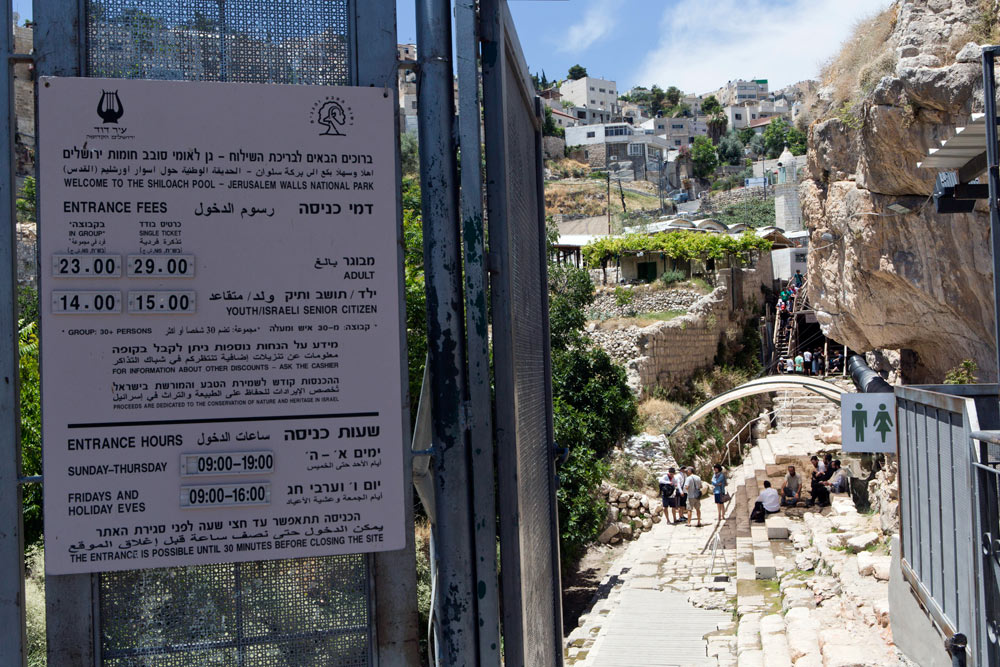
- ^ Sign welcoming visitors to Siloam (Shiloach), printed both in Hebrew and Arabic with traditional names, بتسيلم, 16 September 2014
- ^ Rekhess (2014). "The Arab Minority in Israel: Reconsidering the "1948 Paradigm"". Israel Studies. ج. 19 ع. 2: 187–217. DOI:10.2979/israelstudies.19.2.187. JSTOR:10.2979/israelstudies.19.2.187. S2CID:144053751.
A new trend that has become particularly popular in recent years in mixed Jewish-Arab cities, is attempts to restore original Arabic street names, "Hebraized" after 1948
- ^ Ofer Aderet (29 يوليو 2011). "A stir over sign language: A recently discovered trove of documents from the 1950s reveals a nasty battle in Jerusalem over the hebraization of street and neighborhood names. This campaign is still raging today". هاآرتس. مؤرشف من الأصل في 2023-05-01. اطلع عليه بتاريخ 2011-12-18.
- ^ Rainey, 1978, p.231
- ^ Hopkins, I.W.J. (1968), p. 34. Quote: "Conder collected the current Arabic names for the places on his [P.E.F.] maps, which on the face of it makes them appear to be less useful, compared with Jacotin's [map]. In fact, this makes the P.E.F. map even more useful as evidence of the current Arab place name, and the sheets are not cluttered up with doubtful identifications. The Arabic name is often a corruption of the ancient name and this fact has helped enormously in locating Biblical, Classical and Byzantine sites."
- ^ Conder, Major C. R. (n.d.), pp. 218–219
- ^ أ ب Fields، Gary (5 سبتمبر 2017). Enclosure: Palestinian Landscapes in a Historical Mirror. Univ of California Press. ص. 222. ISBN:978-0-520-29104-1. مؤرشف من الأصل في 2023-05-05.
- ^ Boaz Neumann (2011). Land and Desire in Early Zionism. UPNE. ص. 167. ISBN:978-1-58465-968-6. مؤرشف من الأصل في 2022-04-19.
- ^ Fields، Gary (5 سبتمبر 2017). Enclosure: Palestinian Landscapes in a Historical Mirror. Univ of California Press. ص. 222. ISBN:978-0-520-29104-1. مؤرشف من الأصل في 2023-05-05.Fields, Gary (5 September 2017). Enclosure: Palestinian Landscapes in a Historical Mirror. Univ of California Press. p. 222. ISBN 978-0-520-29104-1.
- ^ أ ب Bitan 1992.
- ^ أ ب ت Maisler et al. 1932.
- ^ Adler, Elkan Nathan (2014), pp. 225, et al.
- ^ Gleichen, Edward , ed. (1925). Quote: (Preface) "The following List of Names in Palestine, having been submitted through H.M. Secretary of State for the Colonies to the High Commissioner, and referred by him for correction to special Arabic and Hebrew subcommittees, is now published by the Permanent Committee on Geographical Names for British Official use."
- ^ المكتب الاستعماري in Palestine (1931), pp. 1, 13, 37, 52, 54–56, 59, 65. Quote: (p. 2) "The list of geographical names has presented many difficulties. Many place names in Palestine are of Arabic origin while others are of Hebrew, Phoenician, Greek, Latin, or Frankish ancestry –– to mention only the most important sources –– but, as most places are inhabited by Arabic-speaking people, local usage has given them names in Arabicised forms or in colloquial Arabic. To adopt the colloquial forms in transliterating names was not considered consistent with the end in view, and as a general rule an effort has been made to put the names in as literary a garb as possible. In most names of Arabic origin this was comparatively easy; but in some the Arab experts recommended the retention of forms not usually admitted in Arabic grammatical word construction."
- ^ Gleichen, Edward (1920), p. 309
- ^ Benvenisti, M. (2000), pp. 47–48. Quote: "The Arab conquerors who colonized the land following the conquest of 638 C.E. settled among its Jewish, Samaritan, and Christian natives. They easily assimilated the Hebrew-Aramaic geographical and topographical names, and, their language being closely related to the Semitic languages spoken there, they made only slight changes in spelling and pronunciation. They had no difficulty finding Arabic forms for names such as Ashkelon –– which they transformed into Asqalan –– Beit Horon to Beit Ghur, Beersheba to Bir Saba'a, and Eilat to Aila."
- ^ Clermont-Ganneau (1896), pp. 67–68, 214, where he wrote: (p. 214) "Tibneh, 'chopped straw', one would swear was Arabic, but it is beyond a doubt that it is the name of the town Timnah, brought into that shape by one of those popular etymologies which are as dear to the peasantry of Palestine as to those of our European countries." On pp. 67–68 he wrote: "One has to beware, however, of these appellations that appear to be of purely Arabic origin, they are often ancient Hebrew names converted by a process of popular etymology into words familiar to the Arabs. In many cases slight phonetic changes assist the process. These, by the bye, are not arbitrary, but are subject to real laws. Thus, for instance, the name of the Bible town of Thimnah has become in fellâh speech Tibneh, 'chopped straw'."
- ^ Robinson, E. (1860), p. 17. See alao John William McGarvey (1829–1911) who quotes Conder on the linguistic evidence of the name, saying that, in Arabic, "the substitution of B for M is so common (as in Tibneh for Timnah)..." See: McGarvey, 2002, pp. 246-247؛ cf. Palmer, E.H. (1881), p. 330, s.v. Tibna
- ^ Kampffmeyer, Georg (1892), p. 38 (section 15)
- ^ Press 2014.
- ^ Tilley (2005), p. 190 نسخة محفوظة 2022-11-30 على موقع واي باك مشين.
- ^ Ettinger، Y. (25 أغسطس 1925). "Determining the Names of the Settlements acquired by the Jewish National Fund" (بעברית). دافار (جريدة إسرائيلية). مؤرشف من الأصل في 2023-05-01.
- ^ Benvenisti 2000.
- ^ Maisler et al. 1932 "Just as they write in Hebrew 'Shechem' rather than Nablus; 'Ḥevron' rather than al-Khalil; 'Yerushalayim' rather than al-Quds, so, too, it is necessary to write [in Hebrew] 'Dor' instead of Ṭanṭūrah; 'Adoraim' instead of Dūra; 'ʻAin Ganim' instead of Jenin؛ 'Naḥal Sorek' instead of Wadi eṣ-Ṣarār, etc."
- ^ "State of Israel Records"، Collection of Publications, no. 277 (PDF) (بעברית)، Jerusalem: Government of Israel، 1953، ص. 630، مؤرشف من الأصل (PDF) في 2023-04-19،
The names of the settlements were mostly determined at different times by the 'Names Committee for the Settlements,' under the auspices of the الصندوق القومي اليهودي (est. 1925), while [other] names were added by the لجنة التسمية الوطنية.
- ^ Benvenisti 2000، صفحة 30.
- ^ A British Mandate map, contained at the مكتبة إسرائيل الوطنية (Eran Laor Cartographic Collection, Jaffa: Survey of Palestine 1928 – 1947, "Palestine" (Pal 1157)); an Ottoman period map, the Palestine Exploration Fund Map, published by the هيئة آثار إسرائيل SWP web-site, and which is chiefly studied by archaeologists and historical geographers when trying to determine what Arabic place names are representative of ancient Hebrew toponymy. Other online maps include: George A. Smathers Libraries: Survey of Palestine map؛ The Palestine Exploration Fund Maps, published by The Digital Archaeological Atlas of the Holy Land; McMaster University - Digitalised maps of Palestine / Israel؛ 1944 Map of Palestine, published by the مكتبة إسرائيل الوطنية. "نسخة مؤرشفة". مؤرشف من الأصل في 2022-07-08. اطلع عليه بتاريخ 2023-05-01.
{{استشهاد ويب}}: صيانة الاستشهاد: BOT: original URL status unknown (link) - ^ Maisler et al. 1932، صفحة 6.
- ^ أ ب Benvenisti 2000، صفحة 12.
- ^ Nur Masalha (9 أغسطس 2012). The Palestine Nakba: Decolonising History, Narrating the Subaltern, Reclaiming Memory. Zed Books Ltd. ص. 72–. ISBN:978-1-84813-973-2. مؤرشف من الأصل في 2022-04-25.
- ^ أ ب Benvenisti 2000، صفحة 17.
- ^ Benvenisti 2000، صفحة 24.
- ^ Benvenisti 2000، صفحة 40.
- ^ "State of Israel Records"، Collection of Publications, no. 152 (PDF) (بעברית)، Jerusalem: Government of Israel، 1951، ص. 845، مؤرشف من الأصل (PDF) في 2023-04-19
- ^ Bitan 1992، صفحة 367.
- ^ Vilnay 1983، صفحة Abstract.
- ^ In the Survey of Western Palestine (Arabic and English Name Lists), London 1881, p. 307, إدوارد هنري بالمر describes the site Khŭrbet Jurfa as "the ruin of the perpendicular bank (cut out by the torrent in the débris of a valley)."
- ^ Avner, Rina (2006). "Rogelit". هيئة آثار إسرائيل (بEnglish). 118. Archived from the original on 2023-01-08.
- ^ Benvenisti 2000، صفحة 49.
- ^ Bitan 1992، صفحة 369.
- ^ In the case of Kiryat Sefer (now موديعين-مكابيم-ريعوت), a name rejected by the Committee in 1994 on grounds that the biblical Kiryat Sefer was located elsewhere, or in the case of Neveh Tzuf, which name was rejected by the Committee (HCJ 146/81) for حلميش, on grounds that a "historical name is not to be copied elsewhere," these names were decided strictly by the Committee, based on Government Statute No. 258 of March 8, 1951, in which it gave to the Government Naming Committee the sole responsibility for the naming of settlements. This decision states that the aforesaid Committee will act in the Prime Minister's Office and that its decisions will be binding upon state institutions: "The committee is the only competent body for determining names for various localities and sites, including intersections, interchanges, tourist sites, nature and landscape, industrial and employment sites and the like in the State of Israel." The Committee's decisions are made in its plenary and published in "Records".
- ^ Rekhess (2014). "The Arab Minority in Israel: Reconsidering the "1948 Paradigm"". Israel Studies. ج. 19 ع. 2: 187–217. DOI:10.2979/israelstudies.19.2.187. JSTOR:10.2979/israelstudies.19.2.187.
A new trend that has become particularly popular in recent years in mixed Jewish-Arab cities, is attempts to restore original Arabic street names, "Hebraized" after 1948
Rekhess (2014). "The Arab Minority in Israel: Reconsidering the "1948 Paradigm"". Israel Studies. 19 (2): 187–217. doi:10.2979/israelstudies.19.2.187. JSTOR 10.2979/israelstudies.19.2.187. S2CID 144053751.A new trend that has become particularly popular in recent years in mixed Jewish-Arab cities, is attempts to restore original Arabic street names, "Hebraized" after 1948
- ^ Ofer Aderet (29 يوليو 2011). "A stir over sign language: A recently discovered trove of documents from the 1950s reveals a nasty battle in Jerusalem over the hebraization of street and neighborhood names. This campaign is still raging today". هاآرتس. مؤرشف من الأصل في 2023-05-01. اطلع عليه بتاريخ 2011-12-18.Ofer Aderet (29 July 2011). "A stir over sign language: A recently discovered trove of documents from the 1950s reveals a nasty battle in Jerusalem over the hebraization of street and neighborhood names. This campaign is still raging today". Haaretz. Retrieved 18 December 2011.
ببليوغرافيا عامة
- Adler, Elkan Nathan (2014). Jewish Travellers (بEnglish). London: Routledge. OCLC:886831002. (first printed in 1930, translated from the original Hebrew)
- Amara، Muhammad (27 سبتمبر 2017). "Hebraization of Arabic Place Names". Arabic in Israel: Language, Identity and Conflict. Taylor & Francis. ISBN:978-1-351-66388-5.
- עזריהו، מעוז؛ Azaryahu، Maoz (2000). "Hebrew and Hebraicization in the Formation of Cultural Identity / עברית ועברות: היבטים של יצירת זהות תרבותית". Jewish Studies / מדעי היהדות. ج. 40: 77–88. JSTOR:23382506.
- Azaryahu، Maoz؛ Golan، Arnon (2001). "(Re)naming the landscape: The formation of the Hebrew map of Israel 1949–1960". Journal of Historical Geography. ج. 27 ع. 2: 178–195. DOI:10.1006/jhge.2001.0297.
- Azaryahu، Maoz؛ Kook، Rebecca (2002). "Mapping the nation: street names and Arab-Palestinian identity: three case studies". Nations and Nationalism. ج. 8 ع. 2: 195–213. DOI:10.1111/1469-8219.00046.
- Nijim، Basheer K.؛ Muammar، Bishara (1984). Toward the de-Arabization of Palestine/Israel, 1945-1977. Kendall/Hunt Pub. Co. ISBN:978-0-8403-3299-8. مؤرشف من الأصل في 2020-09-22.
- Benvenisti، Meron (1 مارس 2000). "The Hebrew Map". Sacred Landscape: The Buried History of the Holy Land since 1948. University of California Press. ص. 1–. ISBN:978-0-520-92882-4. مؤرشف من الأصل في 2022-12-21.
- Bitan، Hana (1992). "Government Names Committee". Eretz-Israel: Archaeological, Historical and Geographical Studies (بעברית). Israel Exploration Society. ج. 23: 366–370. JSTOR:23623609.
- British Colonial Office in Palestine (1931). Government of Palestine: Transliteration from Arabic and Hebrew into English, from Arabic into Hebrew, and from Hebrew into Arabic with transliterated lists of personal and geographical names for use in Palestine (بEnglish). Jerusalem: Goldberg: Printing and Stationery Office. OCLC:748991995.
- Clermont-Ganneau، C.S. (1896). Archaeological Researches in Palestine During the Years 1873–1874. London: صندوق استكشاف فلسطين. ج. 2. مؤرشف من الأصل في 2023-04-20.
- Cohen، Saul B.؛ Kliot، Nurit (1992). "Place-Names in Israel's Ideological Struggle over the Administered Territories". Annals of the Association of American Geographers. ج. 82 ع. 4: 653–680. DOI:10.1111/j.1467-8306.1992.tb01722.x. JSTOR:2563694.
- Conder, Major C.R. (n.d.). Palestine (بEnglish). New York: شركة دود وميد. OCLC:427481948. Archived from the original on 2022-04-19.
- Elitsur، Yoel (2004). Ancient Place Names in the Holy Land: Preservation and History. Hebrew University, Magnes Press. ISBN:978-1-57506-071-2. مؤرشف من الأصل في 2021-05-29.
- Gleichen, Edward (1920). "The Decisions of the Permanent Committee on Geographical Names on the Transliteration of Arabic Characters". The Geographical Journal (بEnglish). الجمعية الجغرافية الملكية (with the Institute of British Geography). 56 (4): 308–313. DOI:10.2307/1781656. JSTOR:1781656.
- Gleichen, Edward, ed. (1925). First List of Names in Palestine - Published for the Permanent Committee on Geographical Names by the Royal Geographical Society (بEnglish). London: الجمعية الجغرافية الملكية. OCLC:69392644.
- Hopkins, I.W.J. (1968). "Nineteenth-Century Maps of Palestine: Dual-Purpose Historical Evidence". Imago Mundi (بEnglish). Imago Mundi Ltd. (Routledge). 22: 30–36. DOI:10.1080/03085696808592315. JSTOR:1150433.
- Kadman، Noga (7 سبتمبر 2015). "Naming and Mapping the Depopulated Village Sites". Erased from Space and Consciousness: Israel and the Depopulated Palestinian Villages of 1948. Indiana University Press. ISBN:978-0-253-01682-9.
- Layton، Scott C. (2018). Archaic Features of Canaanite Personal Names in the Hebrew Bible. BRILL . ISBN:978-9-004-36956-6. مؤرشف من الأصل في 2021-05-23.
- Kampffmeyer, Georg (1892). Alte Namen im heutigen Palästina und Syrien (Old names in what is now Palestine and Syria) (بDeutsch). Leipzig: Breitkopf & Härtel. OCLC:786490264.
- Maisler، B.؛ Ben-Zvi، Y.؛ Klein، S.؛ Press، Y. (1932). "A Memo of the Jewish National Council to the Government of Palestine on the Method of Spelling Transliterated Geographical and Personal Names, plus Two Lists of Geographical Names". Lĕšonénu: A Journal for the Study of the Hebrew Language and Cognate Subjects (بעברית). مجمع اللغة العبرية. ج. 4 ع. 3. JSTOR:24384308.
- Masalha، Nur (9 أغسطس 2012). "The Zionist Superimposing of Hebrew Toponymy". The Palestine Nakba: Decolonising History, Narrating the Subaltern, Reclaiming Memory. Zed Books Ltd. ISBN:978-1-84813-973-2.
- Masalha, Nur (2015), Settler-Colonialism, Memoricide and Indigenous Toponymic Memory: The Appropriation of Palestinian Place Names by the Israeli State, Journal of Holy Land and Palestine Studies, 14 (1). pp. 3-57. ISSN 2054-1988
- McGarvey، J.W. (2002). Lands of the Bible: A Geographical and Topographical Description of Palestine, with Letters of Travel in Egypt, Syria, Asia Minor, and Greece. Adamant Media Corporation. ISBN:978-1-4021-9277-7.
- Palmer، E. H. (1881). The Survey of Western Palestine: Arabic and English Name Lists Collected During the Survey by Lieutenants Conder and Kitchener, R. E. Transliterated and Explained by E.H. Palmer. Committee of the Palestine Exploration Fund. مؤرشف من الأصل في 2023-04-16.
- Peteet، Julie (2005). "Words as Interventions: Naming in the Palestine: Israel Conflict". Third World Quarterly. ج. 26 ع. 1: 153–172. DOI:10.1080/0143659042000322964. JSTOR:3993769. S2CID:144366247.
- Press, Michael D. (2014). "The Arabic Names of Tẹ̄l ʿẸ̄rānī and ʿIrāq el-Menšīye". Zeitschrift des Deutschen Palästina-Vereins (بEnglish). Deutscher verein zur Erforschung Palästinas. 130 (2): 181–193. JSTOR:43664932.
- Ra'ad، Basem L. (15 أغسطس 2010). Hidden Histories: Palestine And The Eastern Mediterranean. Pluto Press. ISBN:978-0-7453-2831-7. مؤرشف من الأصل في 2022-04-19.
- Rainey, A.F. (1978). "The Toponymics of Eretz-Israel". Bulletin of the American Schools of Oriental Research (بEnglish). دار نشر جامعة شيكاغو on behalf of The المدارس الأمريكية للبحث الشرقي. 231 (231): 1–17. DOI:10.2307/1356743. JSTOR:1356743. S2CID:163634741.
- Robinson، E.؛ Smith، E. (1860). Biblical Researches in Palestine and in the Adjacent Regions: A Journal of Travels in the year 1838. Boston: Crocker & Brewster. ج. 2. مؤرشف من الأصل في 2022-04-19.
- Schürer, E. (1891). Geschichte des jüdischen Volkes im Zeitalter Jesu Christi [A History of the Jewish People in the Time of Jesus Christ]. Geschichte de jüdischen Volkes im Zeitalter Jesu Christi.English (بEnglish). Translated by Miss Taylor. New York: Charles Scribner's Sons. Vol. 1. Archived from the original on 2023-04-19.
- Sozomen; Philostorgius (1855). The Ecclesiastical History of Sozomen and The Ecclesiastical History of Philostorgius (بEnglish). Translated by Edward Walford. London: Henry G. Bohn. ISBN:9780790565682. OCLC:224145372. Archived from the original on 2022-04-07.
- Tilley، Virginia (2005). The One-state Solution: A Breakthrough for Peace in the Israeli-Palestinian Deadlock. Manchester University Press. ISBN:978-0-7190-7336-6.
- Vilnay, Zev (1954). "Identification of Talmudic Place Names". The Jewish Quarterly Review (بEnglish). University of Pennsylvania. 45 (2): 130–140. DOI:10.2307/1452901. JSTOR:1452901.
- Vilnay، Z. (1983). "Biblical Words which have Become Place-Names in Israel". Eretz-Israel: Archaeological, Historical and Geographical Studies (بעברית). Israel Exploration Society. 17 (A.J. Brawer Memorial Volume): 86–91. JSTOR:23619490.
- Zuckermann، Ghil'ad (2006). "Toponymy and Monopoly: One Toponym, Two Parents; Ideological Hebraization of Arabic Place-Names in the Israeli Language". Onoma. ج. 41: 163–184. DOI:10.2143/ONO.41.0.2119615.