|
تضامنًا مع حق الشعب الفلسطيني |
وحدة:Location map/data/USA/شرح
| هذه صفحة توثيق وحدة:Location map/data/USA الفرعية، لشرح القالب وتصنيفه، وهي لا تدخل في استخدامه. |
| الاسم | USA | ||
|---|---|---|---|
| x | 50.0 + 124.03149777329222 * ((1.9694462586094064-($1 * pi / 180)) * sin(0.6010514667026994 * ($2 + 96) * pi / 180)) | ||
| y | 50.0 + 1.6155950752393982 * 124.03149777329222 * ( 0.02613325650382181 - (1.3236744353715044 - (1.9694462586094064 - ($1 * pi / 180)) * cos(0.6010514667026994 * ($2 + 96) * pi / 180))) | ||
| صورة image | Usa edcp location map.svg
| ||

| |||
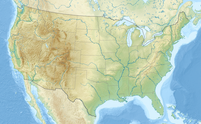
| صورة1 image1 | Usa edcp relief location map.png
| ||

| |||
وحدة:Location map/data/USA هي خريطة موقع تستعمل لتركيب علامات وتسميات في an equidistant conic projection خريطة the الولايات المتحدة. يتم وضع العلامات بواسطة احداثيات خطي العرض والطول في صورة الخريطة الافتراضية، أو صورة خريطة مماثلة.
الاستخدام
These definitions are used by the following templates when invoked with parameter "USA":
{{خريطة مواقع| USA | ...}}{{Location map many| USA | ...}}{{خريطة مواقع+| USA | ...}}{{خريطة مواقع~| USA | ...}}
تعريف الخريطة
name = USA- الاسم المستخدم في التسمية التوضيحية للخريطة الافتراضية
image = Usa edcp location map.svg- الصورة الافتراضية دون "Image:" أو "صورة:" أو "File:" أو "ملف:"
image1 = Usa edcp relief location map.png- An alternative map image, usually a relief map, can be displayed via the relief or AlternativeMap parameters
x = 50.0 + 124.03149777329222 * ((1.9694462586094064-($1 * pi / 180)) * sin(0.6010514667026994 * ($2 + 96) * pi / 180))- An expression to calculate a location on the map via its طول جغرافي; evaluates as 0 along the left edge and 100 along the right edge
y = 50.0 + 1.6155950752393982 * 124.03149777329222 * ( 0.02613325650382181 - (1.3236744353715044 - (1.9694462586094064 - ($1 * pi / 180)) * cos(0.6010514667026994 * ($2 + 96) * pi / 180)))- An expression to calculate a location on the map via its عرض جغرافي; evaluates as 0 along the top edge and 100 along the bottom edge
خريطة بديلة
The map defined as image1 (Usa edcp relief location map.png) can be displayed by using the relief or AlternativeMap parameters in {{خريطة مواقع}}, {{Location map many}} and {{خريطة مواقع+}}. The use of these two parameters is shown in the examples below. Additional examples can be found at:
أمثلة على استخدام قوالب خريطة الموقع
Location map, using default map (image)
{{خريطة مواقع| USA
| width   = 250
| label   = Washington, D.C.
| lat_deg = 38.89
| lon_deg = -77.04
}}
Location map many, using relief map (image1)
{{Location map many| USA
| relief   = yes
| width    = 250
| caption  = Two locations in the USA
| label1   = Washington, D.C.
| lat1_deg = 38.89
| lon1_deg = -77.04
| label2   = Seattle
| lat2_deg = 47.61
| lon2_deg = -122.33
}}
Location map+, using AlternativeMap
{{خريطة مواقع+| USA
| AlternativeMap = Usa edcp relief location map.png
| caption = Two locations in the USA
| width   = 250
| places  =
  {{خريطة مواقع~| USA
  | label   = Washington, D.C.
  | lat_deg = 38.89
  | lon_deg = -77.04
  }}
  {{خريطة مواقع~| USA
  | label   = Seattle
  | lat_deg = 47.61
  | lon_deg = -122.33
  }}
}}
أنظر أيضا
- قوالب خريطة الموقع
- قالب:خريطة مواقع، لعرض علامة واحدة وتسمية باستخدام خطوط الطول والعرض.
- قالب:Location map many، لعرض ما يصل إلى تسع علامات وملصقات.
- قالب:خريطة مواقع+،لعرض عدد غير محدود من العلامات والملصقات.

