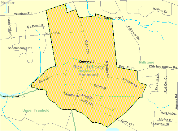
ملف:Census Bureau map of Roosevelt, New Jersey.png

من أرابيكا، الموسوعة الحرة
اذهب إلى التنقل اذهب إلى البحث

Census_Bureau_map_of_Roosevelt,_New_Jersey.png(575 × 425 بكسل حجم الملف: 24 كيلوبايت، نوع MIME: image/png)

ملخص

الوصف
English: Census Bureau map of Roosevelt
المصدر United States Census Bureau
المؤلف United States Census Bureau

ترخيص

Public domain
This image or file is a work of a United States Census Bureau employee, taken or made as part of that person's official duties. As a work of the U.S. federal government, the image is in the public domain.

English  español  日本語  македонски  മലയാളം  português do Brasil  русский  українська  עברית  +/−


سجلُّ الرَّفع الأصيل

نُقِلت من en.wikipedia إلى كُومُنز بواسطة Quadell باستخدام CommonsHelper.

صفحة الوصف الأصلية كانت هنا، تشير جميع أسماء المستخدمين التالية إلى en.wikipedia.
  • 2008-11-11 23:36 Alansohn 575×425× (26133 bytes) {{Information |Description=Census Bureau map of [[Roosevelt, New Jersey]] |Source=[[United States Census Bureau]] |Date= |Author=[[United States Census Bureau]] |Permission= |other_versions= }}

سجلُّ الرَّفع الأصيل

زمن/تاريخ الأبعاد مستخدم تعليق
٥ يوليو ٢٠١٣, ١٨:٣٥:٥٤ 575 × 425 (26133 bytes) File Upload Bot (Magnus Manske) (نقاش · مساهمات) Transfered from en.wikipedia by [[User:Quadell]] using CommonsHelper

الشروحات

أضف شرحاً من سطر واحد لما يُمثِّله هذا الملف

العناصر المصورة في هذا الملف

يُصوِّر

1adf7bb2e868fa69ccaf760c81322880e0a6390d

٢٤٬٧١٨ بايت

٤٢٥ بكسل

٥٧٥ بكسل

تاريخ الملف

اضغط على زمن/تاريخ لرؤية الملف كما بدا في هذا الزمن.

زمن/تاريخصورة مصغرةالأبعادمستخدمتعليق
حالي22:57، 20 نوفمبر 2014تصغير للنسخة بتاريخ 22:57، 20 نوفمبر 2014575 × 425 (24 كيلوبايت)commonswiki>GifTaggerBot: Converting file to superior PNG file. (Source: Census_Bureau_map_of_Roosevelt,_New_Jersey.gif). This GIF was problematic due to non-greyscale color table.

ال1 ملف التالي مكررات لهذا الملف (المزيد من التفاصيل):

الصفحة التالية تستخدم هذا الملف: