|
تضامنًا مع حق الشعب الفلسطيني |
ملف:Battle of Fort Blakely map.png

الملف الأصلي (1٬500 × 1٬130 بكسل حجم الملف: 866 كيلوبايت، نوع MIME: image/png)
| هذا ملف من ويكيميديا كومنز. معلومات من صفحة وصفه مبينة في الأسفل. كومنز مستودع ملفات ميديا ذو رخصة حرة. |
ملخص
| الوصف |
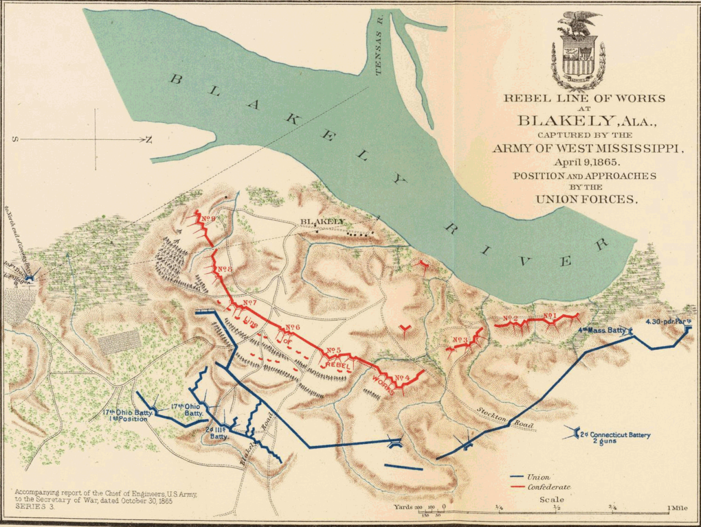
English: Short Title: Mobile, Blakely, Messinger's Ferry-Canton.
Publisher: Washington: U.S. Government Printing Office Three col. maps, with 15 ancillary maps. Relief shown by hachures. Campaign map 11 contains 4 maps. Accompany reports of Chief of Engineers, U.S. Army, A.S. Williams and James B. McPherson. No. 10. Map of the defenses of the city of Mobile. Rebel line of works at Blakely, Ala., captured by the Army of West Mississippi, April 9, 1865. Position and approaches by the Union forces. Expedition from Messinger's Ferry toward Canton, Miss., October 14-20, 1863. (with) Campaign maps, numbers 1 to 11 inclusive, showing position of 20th Army Corps on march from Atlanta, Ga. to Savannah, Ga., with dates and Union and rebel defenses, from surveys of Topographical Engineers 20th Army Corps. Position of troops by Lieut. Col. C.W. Asmussen ... December 1864. (with) Position occupied by troops from French's division at the crossing of the Cattahoochee River. S.G. French, Major-General, C.S. Army. Julius Bien & Co., Lith., N.Y. (1891-1895) Engraver or Printer: Julius Bien & Co. ; Asmussen, Charles W. ; French, Samuel G. Published title: Atlas to accompany the official records of the Union and Confederate armies. Published under the direction of the Hons. Redfield Proctor, Stephen B. Elkins and Daniel S. Lamont, secretaries of war, by Maj. George B. Davis, U.S. Army, Mr. Leslie J. Perry, civilian expert, Mr. Joseph W. Kirkley, civilian expert, Board of Publication. Compiled by Capt. Calvin D. Cowles, 23d U.S. Infantry. Washington: Government Printing Office, 1891-1895. Published reference: LC Civil War maps (2nd ed.), 99; Civil War maps in the National Archives, 8; Phillips, 1353; LeGear. Atlases of the United States, 266. |
| التاريخ | |
| المصدر |
Source: http://www.davidrumsey.com/ Transferred from en.wikipedia to Commons by User:Innotata using CommonsHelper |
| المؤلف | United States War Department |
ترخيص
تقع هذه الصُّورة في النِّطاق االعامِّ في الولايات المُتحدة الأَمريكيَّة لأَنَّها عملٌ أُعدَّ مِن ضابطٍ أَو مُوظَّفٍ في الحكومة الاتحاديَّة للولايات المُتحدة في أَثناء قيامه بواجباته الرَّسميَّة، انظر في البند 17 الفصلَ 1 وفيه القسم 105 من قانون الولايات المُتحدة الأمريكيَّة.
ملاحظة: ينطبق هذا فقط على الأعمال الأصيلة للحكومة الاتحادية وليس على أعمال الولايات أو التبعيات فُرادى ولا على أَيِّ تقسيماتٍ إِداريَّةٍ أُخرى. لا ينطبق هذا القالب أيضاً على على تصاميم الطَّوابع البريديَّة الَّتي نَشرتها الخدمة البريدية للولايات المتحدة منذ العام 1978م. (انظر § 313.6(C)(1) مِن خُلاصة الممارسات العمليَّة لمَكتب حقوق التَّأليف والنَّشر الأمريكية). ولا تَنطبق أَيضاً على بعض قطع النُّقود المعدنيَّة الأَمريكيَّة ;شروط استخدام دار سكِّ العملة الأَمريكيَّة.
|
 | |
| هذا الملفُّ مَلحُوظُ بصفته غيرَ مُقيَّدٍ بحقوق التَّأليف والنشر، وهذا يشمل أيضاً الحقوق المُجاوِرة أَو ذات الصلة جميعُها. | ||
سجلُّ الرَّفع الأصيل
- 2005-01-01 06:19 Brian0918 1500×1130× (886601 bytes) Author: United States. War Department<br>Date: 1895<br>Short Title: Mobile, Blakely, Messinger's Ferry-Canton.<br>Publisher: Washington: U.S. Government Printing Office<br>Three col. maps, with 15 ancillary maps. Relief shown by hachures. Campaign map 11
تاريخ الملف
اضغط على زمن/تاريخ لرؤية الملف كما بدا في هذا الزمن.
| زمن/تاريخ | صورة مصغرة | الأبعاد | مستخدم | تعليق | |
|---|---|---|---|---|---|
| حالي | 22:13، 7 يوليو 2011 | | 1٬500 × 1٬130 (866 كيلوبايت) | commonswiki>File Upload Bot (Magnus Manske) | {{BotMoveToCommons|en.wikipedia|year={{subst:CURRENTYEAR}}|month={{subst:CURRENTMONTHNAME}}|day={{subst:CURRENTDAY}}}} {{Information |Description={{en|Short Title: Mobile, Blakely, Messinger's Ferry-Canton. Publisher: Washington: U.S. Government Printing |
استخدام الملف
ال1 ملف التالي مكررات لهذا الملف (المزيد من التفاصيل):
- ملف:Battle of Fort Blakely map.png من ويكيميديا كومنز
الصفحة التالية تستخدم هذا الملف: