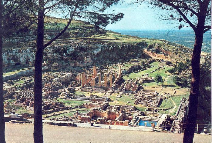
ملف:Ruins of Cyrene.jpg

Ruins_of_Cyrene.jpg(699 × 472 بكسل حجم الملف: 108 كيلوبايت، نوع MIME: image/jpeg)

الوصف
English: Ruins of Cyrene.
التاريخ بين ١٩٦٥ و ١٩٧٥
date QS:P,+1950-00-00T00:00:00Z/7,P1319,+1965-00-00T00:00:00Z/9,P1326,+1975-00-00T00:00:00Z/9
المصدر albakour.com
المؤلف not mentioned
الترخيص
(إعادة استخدام هذا الملف)
Public domain This work was first published on the Libya and is now in the public domain because its copyright protection has expired by virtue of the Copyright Protection Law, enacted 1968. The work meets one of the following criteria:
  • It is an anonymous work or pseudonymous work and 25 years have passed since the date of its publication
  • It is a work published after the death of the author and 50 have passed since the year of death of the author (or last-surviving author)
  • It is a photographic or cinematographic work that is not compositive (artistic in nature) and 5 years have elapsed since the end of the year of its publication
  • It is a work created by a legal public or private entity and 30 years have passed since the year the work was created
  • It is another type of work and than 25 years have elapsed since the the year of death of the author (or last-surviving author) and fifty years have elapsed since the year of publication.
  • It is one of "official documents such as texts of laws, decrees, regulations, international agreements, legal judgements and various official documents"

أنتَ أيضاً مُلزمٌ بتضمين وسم النَّطاق العامّ لتحديد السبب الَّذي يجعلُ من هذا العمل مِلكيَّةً عامةً في الولايات المُتحدة الأمريكيَّة
إصدارات أخرى
موقع آلة التصوير٣٢° ٤٩′ ٢٤٫٨٥″ ش, ٢١° ٥١′ ١٥٫٤٨″ ق Kartographer map based on OpenStreetMap.هذه وغيرها من الصور في مواقعها على: خريطة الشارع المفتوحةinfo
موقع الكائن٣٢° ٤٩′ ٢٤٫٥٣″ ش, ٢١° ٥١′ ٠٨٫٧٥″ ق Kartographer map based on OpenStreetMap.هذه وغيرها من الصور في مواقعها على: خريطة الشارع المفتوحةinfo

الشروحات

أضف شرحاً من سطر واحد لما يُمثِّله هذا الملف

العناصر المصورة في هذا الملف

يُصوِّر

32°49'24.85"N, 21°51'15.48"E

coordinates of depicted place الإنجليزية

32°49'24.53"N, 21°51'8.75"E

تاريخ الملف

اضغط على زمن/تاريخ لرؤية الملف كما بدا في هذا الزمن.

زمن/تاريخصورة مصغرةالأبعادمستخدمتعليق
حالي19:57، 13 يونيو 2009تصغير للنسخة بتاريخ 19:57، 13 يونيو 2009699 × 472 (108 كيلوبايت)commonswiki>Elmondo21st{{Information |Description={{en|1=Ruins of Cyrene.}} |Source= [http://albakour.com/album/displayimage.php?album=22&pos=8 albakour.com] |Date=1965-1975 |Author=not mentioned |Permission={{PD-Libya}} |other_versions= }} <!--{{ImageUpload|basic}}-->

ال1 ملف التالي مكررات لهذا الملف (المزيد من التفاصيل):

ال4 صفحات التالية تستخدم هذا الملف:

بيانات وصفية