ملف:London - John Norden's map of 1593.jpg

حجم هذه المعاينة: 638 × 600 بكسل. الأبعاد الأخرى: 255 × 240 بكسل | 511 × 480 بكسل | 817 × 768 بكسل | 1٬089 × 1٬024 بكسل | 2٬179 × 2٬048 بكسل | 4٬000 × 3٬760 بكسل.
الملف الأصلي (4٬000 × 3٬760 بكسل حجم الملف: 4٫01 ميجابايت، نوع MIME: image/jpeg)
| هذا ملف من ويكيميديا كومنز. معلومات من صفحة وصفه مبينة في الأسفل. كومنز مستودع ملفات ميديا ذو رخصة حرة. |
| الوصف |
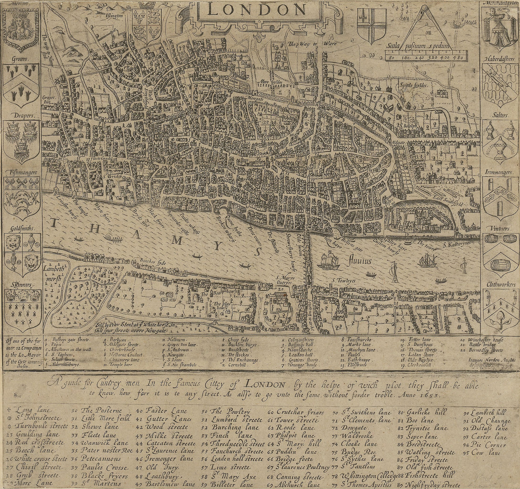
English: A guide for Cuntrey men In the famous Cittey of London. A map of London by John Norden, 1593. This copy comes from the 1653 edition of Norden's Speculum Britainiæ (Mirror of Britain), re-issued after his death.
There is only one bridge across the Thames, but parts of Southwark on the south bank of the river have been developed. The coats of arms around the edge belong to the twelve largest city guilds. These arms collectively were known as the "Great Liveries". Top right is the Merchant Tailors' arms.
|
||||
| التاريخ | 1593, re-issued in 1653 | ||||
| المصدر | British Library: http://www.bl.uk/onlinegallery/onlineex/crace/a/007000000000001u00033000.html | ||||
| المؤلف | John Norden | ||||
| الترخيص (إعادة استخدام هذا الملف) |
|
||||
تاريخ الملف
اضغط على زمن/تاريخ لرؤية الملف كما بدا في هذا الزمن.
| زمن/تاريخ | صورة مصغرة | الأبعاد | مستخدم | تعليق | |
|---|---|---|---|---|---|
| حالي | 06:49، 19 فبراير 2010 | | 4٬000 × 3٬760 (4٫01 ميجابايت) | commonswiki>Inductiveload | much higher res version |
استخدام الملف
ال1 ملف التالي مكررات لهذا الملف (المزيد من التفاصيل):
- ملف:London - John Norden's map of 1593.jpg من ويكيميديا كومنز
الصفحة التالية تستخدم هذا الملف: