ملف:Germany Morgenthau Plan-en.svg

حجم معاينة PNG لذلك الملف ذي الامتداد SVG: 666 × 599 بكسل. الأبعاد الأخرى: 267 × 240 بكسل | 533 × 480 بكسل | 853 × 768 بكسل | 1٬138 × 1٬024 بكسل | 2٬276 × 2٬048 بكسل | 1٬000 × 900 بكسل.
الملف الأصلي (ملف SVG، أبعاده 1٬000 × 900 بكسل، حجم الملف: 129 كيلوبايت)
| هذا ملف من ويكيميديا كومنز. معلومات من صفحة وصفه مبينة في الأسفل. كومنز مستودع ملفات ميديا ذو رخصة حرة. |
ملخص
| الوصف |
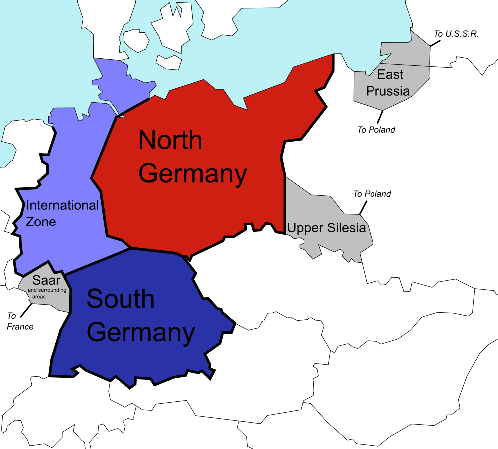
English: The (1944) U.S. "Morgenthau Plan" showing the planned partitioning of Germany into a North State, a South State, and an International zone. Areas in grey are areas intended for annexation by France, Poland and the U.S.S.R. |
| التاريخ | |
| المصدر |
هذا الملفُّ مُشتقٌ مِن : Germany Morgenthau Plan.png: |
| المؤلف |
أصلي: المتجه: |
| SVG منشأ الملف |
ترخيص
| أنا، مالِك حقوق تأليف ونشر هذا العمل، أجعله في النِّطاق العامِّ، يسري هذا في أرجاء العالم كلِّه. في بعض البلدان، قد يكون هذا التَّرخيص غيرَ مُمكنٍ قانونيَّاً، في هذه الحالة: أمنح الجميع حق استخدام هذا العمل لأي غرض دون أي شرط ما لم يفرض القانون شروطًا إضافية. |
سجلُّ الرَّفع الأصيل
This image is a derivative work of the following images:
- File:Germany Morgenthau Plan.png licensed with Cc-by-sa-3.0-migrated, GFDL, PD-self
- 2006-07-06T08:40:57Z Stor stark7 998x896 (149331 Bytes) The (1944) "Morgenthau Plan" map showing the planned partitioning of Germany into a North State, a South State, and an International zone. Areas in grey are areas proposed for annexation by France, Poland, and the U.S.S.R.(to
- 2006-07-05T20:52:36Z Stor stark7 998x896 (149331 Bytes) The background template used for this image was the following fre license image: http://upload.wikimedia.org/wikipedia/commons/4/43/Duitslandmorgenthau.png The Modification of the map, in order to portray the dismemberment o
- 2006-03-18T15:00:50Z Stor stark7 998x896 (147165 Bytes) own made
Uploaded with derivativeFX
تاريخ الملف
اضغط على زمن/تاريخ لرؤية الملف كما بدا في هذا الزمن.
| زمن/تاريخ | صورة مصغرة | الأبعاد | مستخدم | تعليق | |
|---|---|---|---|---|---|
| حالي | 00:40، 26 يوليو 2019 | | 1٬000 × 900 (129 كيلوبايت) | commonswiki>Redrobsche | White Background |
استخدام الملف
ال1 ملف التالي مكررات لهذا الملف (المزيد من التفاصيل):
- ملف:Germany Morgenthau Plan-en.svg من ويكيميديا كومنز
الصفحة التالية تستخدم هذا الملف: