ملف:16th century Portuguese Spanish trade routes.png

من أرابيكا، الموسوعة الحرة
اذهب إلى التنقل اذهب إلى البحث

الملف الأصلي(2٬835 × 1٬188 بكسل حجم الملف: 2 ميجابايت، نوع MIME: image/png)

الوصف

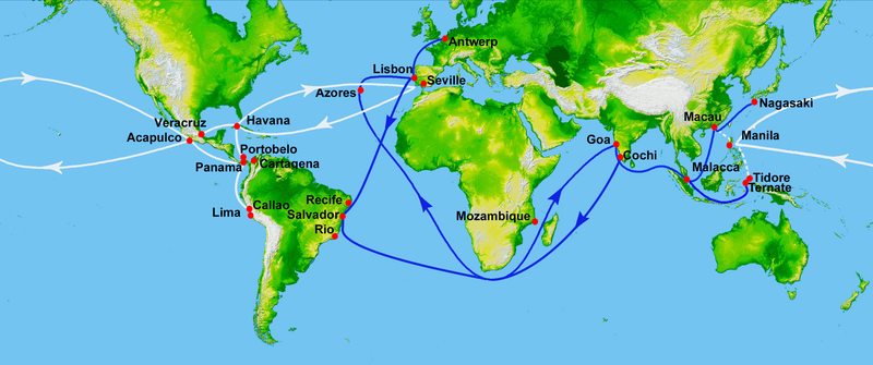
Map showing main Portuguese (blue) and Spanish (white) oceanic trade routes in the 16th century, as a result of the exploration during the Age of Discovery.

التاريخ (UTC)
المصدر
المؤلف


هذا رسمٌ مُعَدَّلٌ رقميَّاً من النسخة الأصليَّة. التعديلات هي: depiction of 16th century Portuguese and Spanish trade routes. يُمكن الاطلاع على النسخة الأصليَّة هنا: World Topography.jpg. المُستخدم الذي أجرى التعديلات هو: Uxbona.


Public domain
Public domain
This image uses high-resolution digital topography data from NASA's Shuttle Radar Topography Mission (SRTM) at JPL-Caltech [1]. It is in the public domain in the United States.

NASA shuttle
NASA shuttle
English | Bahasa Indonesia | македонски | polski | português | 中文 | 中文(简体)‎ | +/−

سجلُّ الرَّفع الأصيل

This image is a derivative work of the following images:

  • File:World_Topography.jpg licensed with PD-USGov-NASA-SRTM
    • 2009-03-17T12:12:25Z Sk 21600x9049 (17145460 Bytes) {{Information |Description=PIA03395: World in Mercator Projection, Shaded Relief and Colored Height |Source=http://photojournal.jpl.nasa.gov/catalog/PIA03395 |Date=February 2000 |Author=NASA/JPL/NIMA |Permission={{PD-USGov-

Uploaded with derivativeFX

الشروحات

أضف شرحاً من سطر واحد لما يُمثِّله هذا الملف

العناصر المصورة في هذا الملف

يُصوِّر

١٥ مايو 2010

١٬١٨٨ بكسل

٢٬٨٣٥ بكسل

٢٬٠٩٣٬٩٥٤ بايت

تاريخ الملف

اضغط على زمن/تاريخ لرؤية الملف كما بدا في هذا الزمن.

زمن/تاريخصورة مصغرةالأبعادمستخدمتعليق
حالي03:50، 16 يوليو 2023تصغير للنسخة بتاريخ 03:50، 16 يوليو 20232٬835 × 1٬188 (2 ميجابايت)commonswiki>HohumBrighten

ال1 ملف التالي مكررات لهذا الملف (المزيد من التفاصيل):

الصفحتان التاليتان تستخدمان هذا الملف:

بيانات وصفية