|
تضامنًا مع حق الشعب الفلسطيني |
ملف:Yazoo River control structure.jpg
اذهب إلى التنقل
اذهب إلى البحث

حجم هذه المعاينة: 800 × 533 بكسل. الأبعاد الأخرى: 320 × 213 بكسل | 640 × 427 بكسل | 1٬024 × 683 بكسل | 1٬500 × 1٬000 بكسل.
الملف الأصلي (1٬500 × 1٬000 بكسل حجم الملف: 345 كيلوبايت، نوع MIME: image/jpeg)
| هذا ملف من ويكيميديا كومنز. معلومات من صفحة وصفه مبينة في الأسفل. كومنز مستودع ملفات ميديا ذو رخصة حرة. |
| الوصف |
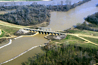
English: One of many control structures used to control flooding and the flow of water in the low-lying Yazoo River Basin in Mississippi, USA. |
|||
| الموقع | Yazoo River Basin, Mississippi, USA | |||
| التاريخ | not specified or unknown | |||
| المصدر |
U.S. Army Corps of Engineers Digital Visual Library Image page Image description page Digital Visual Library home page |
|||
| المؤلف | Alfred Dulaney, U.S. Army Corps of Engineers | |||
| الترخيص (إعادة استخدام هذا الملف) |
|
تاريخ الملف
اضغط على زمن/تاريخ لرؤية الملف كما بدا في هذا الزمن.
| زمن/تاريخ | صورة مصغرة | الأبعاد | مستخدم | تعليق | |
|---|---|---|---|---|---|
| حالي | 20:48، 7 أبريل 2007 | | 1٬500 × 1٬000 (345 كيلوبايت) | commonswiki>DanMS | {{Information | Description = {{en|One of many control structures used to control flooding and the flow of water in the low-lying Yazoo River Basin in Mississippi, USA.}} | Source = U.S. Army Corps of Engineers Digital Visual Library<br />[http |
استخدام الملف
ال1 ملف التالي مكررات لهذا الملف (المزيد من التفاصيل):
- ملف:Yazoo River control structure.jpg من ويكيميديا كومنز
الصفحة التالية تستخدم هذا الملف: