|
تضامنًا مع حق الشعب الفلسطيني |
ملف:WWI.png
اذهب إلى التنقل
اذهب إلى البحث
حجم هذه المعاينة: 800 × 333 بكسل. الأبعاد الأخرى: 320 × 133 بكسل | 640 × 266 بكسل | 1٬502 × 625 بكسل.
الملف الأصلي (1٬502 × 625 بكسل حجم الملف: 52 كيلوبايت، نوع MIME: image/png)
| هذا ملف من ويكيميديا كومنز. معلومات من صفحة وصفه مبينة في الأسفل. كومنز مستودع ملفات ميديا ذو رخصة حرة. |
ملخص
| الوصف |
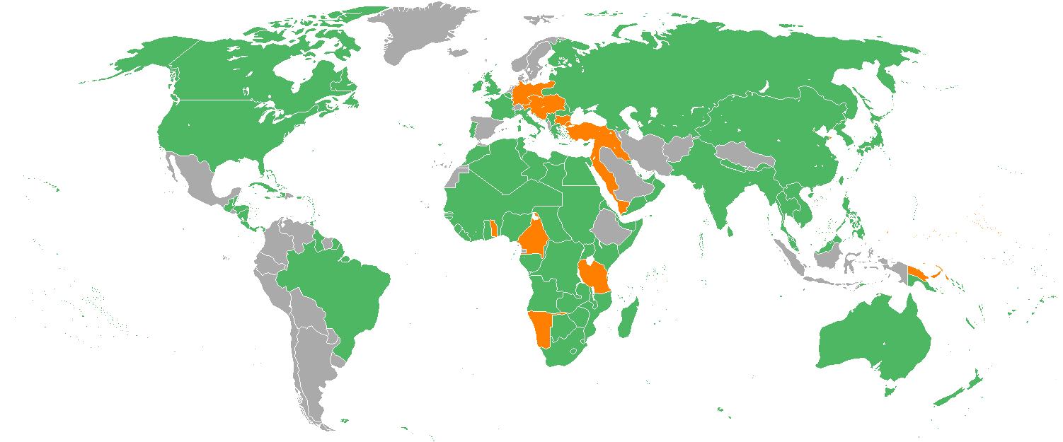
English: Map with the Participants in World War I:
Русский: Карта мира начала XX в. с границами альянсов:
Deutsch: Karte der Beteiligten des Ersten Weltkrieges:
|
| التاريخ | ٢٢ ديسمبر ٢٠٠٥ (تاريخ الرفع الأصيل) |
| المصدر | نُقِلت من en.wikipedia إلى كُومُنز . |
| المؤلف | Helmandsare, Joaopais, El Jaber, Aivazovsky + Various (انظر أدناه.) |
| إصدارات أخرى |
|


|
هذه military map الصورة / الصورتان باستعمال رسومات متجهية ملفات رسوميات شعاعية.
It is recommended to name the SVG file "WWI.svg" - then the template Vector version available (or Vva) does not need the new image name parameter.
|
ترخيص
Aivazovsky at the English Wikipedia، صاحب حقوق التأليف والنشر لهذا العمل، أنشر هذا العمل تحت الرخصة التالية:

|
يسمح نسخ وتوزيع و/أو تعديل هذه الوثيقة تحت شروط رخصة جنو للوثائق الحرة، الإصدار 1.2 أو أي إصدار لاحق تنشره مؤسسة البرمجيات الحرة؛ دون أقسام ثابتة ودون نصوص أغلفة أمامية ودون نصوص أغلفة خلفية. نسخة من الرخصة تم تضمينها في القسم المسمى GNU Free Documentation License. |
| هذا الملفُّ مُرخَّص بموجب رخصة المشاع الإبداعي نسبة المُصنَّف إِلى مُؤَلِّفه - المشاركة بالمثل 3.0 العامة | ||
| نسب العمل لمُؤَلِّفه: Aivazovsky at the English Wikipedia | ||
| ||
| تمت إضافة علامة الترخيص لهذا الملف كجزء من رخصة جنو للوثائق الحرة تحديث الترخيص. |
سجلُّ الرَّفع الأصيل
صفحة الوصف الأصلية كانت هنا، تشير جميع أسماء المستخدمين التالية إلى en.wikipedia.
- 2007-02-14 15:32 Aivazovsky 1357×628×8 (30657 bytes) Fixed northern islands of Russia and Norway, fixed borders of Russia's South Caucasus territory
- 2006-05-02 21:54 Helmandsare 1357×628×8 (30663 bytes)
- 2006-01-19 19:34 Joaopais 1357×628×8 (30415 bytes)
- 2006-01-15 12:12 El Jaber 1357×628×8 (45477 bytes) Map with the [[Participants in World War I]]: * <font color="green">''Green''</font>: [[Allies of World War I|Allies]] * <font color="red">''Red''</font>: [[Central Powers]] * <font color="yellow">''Yellow''</font>: [[Neutral Country|Neutral Countries]]
- 2005-12-22 00:53 Joaopais 1357×628×8 (30366 bytes) added Belize and the Guyanas (at the time British and French colonies)
- 2005-12-22 00:19 Joaopais 1357×628×8 (30365 bytes) Map with the [[Participants in World War I]]: * <font color="green">''Green''</font>: [[Allies of World War I|Allies]] * <font color="orange">''Orange''</font>: [[Axis Powers]]
تاريخ الملف
اضغط على زمن/تاريخ لرؤية الملف كما بدا في هذا الزمن.
| زمن/تاريخ | صورة مصغرة | الأبعاد | مستخدم | تعليق | |
|---|---|---|---|---|---|
| حالي | 22:19، 27 فبراير 2014 | | 1٬502 × 625 (52 كيلوبايت) | commonswiki>Grachifan | major update |
استخدام الملف
ال1 ملف التالي مكررات لهذا الملف (المزيد من التفاصيل):
- ملف:WWI.png من ويكيميديا كومنز
الصفحة التالية تستخدم هذا الملف: