|
تضامنًا مع حق الشعب الفلسطيني |
ملف:Venusvulkan Tick-Typ.jpg

الملف الأصلي (1٬637 × 1٬433 بكسل حجم الملف: 770 كيلوبايت، نوع MIME: image/jpeg)
| هذا ملف من ويكيميديا كومنز. معلومات من صفحة وصفه مبينة في الأسفل. كومنز مستودع ملفات ميديا ذو رخصة حرة. |
| الوصف |
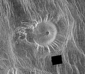
This Magellan image is of an area located in the Eistla Region [Error: This is in the Alpha Regio[1]] of Venus in the southern hemisphere and is centered at 5.5 degrees east longitude, 18 degrees south latitude. It is 122 kilometers (76 miles) across east to west and 107 kilometers (66 miles) north to south. North is at the top of the image. Shown is an unusual volcanic edifice unlike all others previously observed. It is approximately 66 kilometers (41 miles) across at the base and has a relatively flat, slightly concave summit 35 kilometers (22 miles) in diameter. The sides of the edifice are characterized by radiating ridges and valleys that impart a fluted appearance. To the west, the rim of the structure appears to have been breached by dark lava flows that emanated from a shallow summit pit approximately 5 kilometers (3 miles) in diameter and traveled west along a channel approximately 5 kilometers wide and 27 kilometers (17 miles) long. A series of coalescing, collapsed pits 2 to 10 kilometers (1.2 to 6.2 miles) in diameter are located 10 kilometers (6 miles) west of the summit. The edifice and western pits are circumscribed by faint, concentric lineaments up to 70 kilometers (43 miles) in diameter. A series of north northwest trending graben are deflected eastward around the edifice; the interplay of these graben and the fluted rim of the edifice produce a distinctive scalloped pattern in the image. Several north northwest trending lineaments cut directly across the summit region. This peculiar volcanic construct is located 25 to 30 kilometers (15 to 19 miles) north of Alpha Regio, a highly deformed region of tessera terrain. A collection of at least six similar volcanoes has been observed near Thetis Regio, a region of tessera within Aphrodite Terra. Thus, these unusual constructs tentatively appear to be spatially associated with regions of tessera. A tessera is a complex, deformed terrain on Venus consisting of at least two sets of intersecting ridges and troughs. The implications of this spatial association on the unusual morphology of these constructs are being investigated. The feature is unnamed as for 2016 (a map of the region) |
| التاريخ | image published 29. Jan. 1996 |
| المصدر |
NASA planetary photojournal |
| المؤلف | NASA/JPL |
| الترخيص (إعادة استخدام هذا الملف) |
Copyright information from http://www.jpl.nasa.gov/images/policy/index.cfm - Unless otherwise noted, images and video on JPL public web sites (public sites ending with a jpl.nasa.gov address) may be used for any purpose without prior permission [...] |
فُهرِست هذه الصُّورة أَو هذا التَّسجيل المرئي لدى وهو أحد المراكز التَّابعة لوكالة الفضاء الأَمريكيَّة (ناسا) تحت المُعرِّف PIA00089. لا يُشير هذه الوَسم إلى حالة حقوق التَّأليف والنَّشر الخاصَّة بالعمل المُرفَق؛ لا يزال وَسم حقوق التَّأليف والنَّشر مَطلُوباً، راجع كومنز:ترخيص لمزيدٍ من المعلومات. لغات أخرى:
|
| يقع هذا العمل في النِّطاق العامّ في الولايات المُتحدة الأمريكيَّة لأَنَّه عملٌ خالِصٌ من إِنتاج وكالة الفضاء الأمريكيَّة. تنصُ حقوق التَّأليف والنَّشر الخاصَّة بوكالة الفضاء الأمريكيَّة على أنَّ "أعمال الوكالة غير مَحميَّة بحقوق التَّأليف والنَّشر ما لم يُذكر خلافُ ذلك". لمزيدٍ من المعلومات انظر القالِب {{PD-USGov}} وصفحة حقوق التَّأليف والنَّشر الخاصَّة بالوكالة وصفحة سياسة الصُّور الخاصَّة بمُختبر الدَّفع النَّفَّاث. | ||
 |
تنبيهات:
|
تاريخ الملف
اضغط على زمن/تاريخ لرؤية الملف كما بدا في هذا الزمن.
| زمن/تاريخ | صورة مصغرة | الأبعاد | مستخدم | تعليق | |
|---|---|---|---|---|---|
| حالي | 02:19، 13 فبراير 2006 | | 1٬637 × 1٬433 (770 كيلوبايت) | commonswiki>Arnomane | higher resolution |
استخدام الملف
ال1 ملف التالي مكررات لهذا الملف (المزيد من التفاصيل):
- ملف:Venusvulkan Tick-Typ.jpg من ويكيميديا كومنز
الصفحة التالية تستخدم هذا الملف: