|
تضامنًا مع حق الشعب الفلسطيني |
ملف:Upper Terraces of Mammoth Hot Springs.jpg
اذهب إلى التنقل
اذهب إلى البحث

حجم هذه المعاينة: 800 × 569 بكسل. الأبعاد الأخرى: 320 × 228 بكسل | 640 × 455 بكسل | 1٬024 × 728 بكسل | 1٬280 × 910 بكسل | 2٬100 × 1٬493 بكسل.
الملف الأصلي (2٬100 × 1٬493 بكسل حجم الملف: 2٫17 ميجابايت، نوع MIME: image/jpeg)
| هذا ملف من ويكيميديا كومنز. معلومات من صفحة وصفه مبينة في الأسفل. كومنز مستودع ملفات ميديا ذو رخصة حرة. |
|

ملخص
| الوصف |
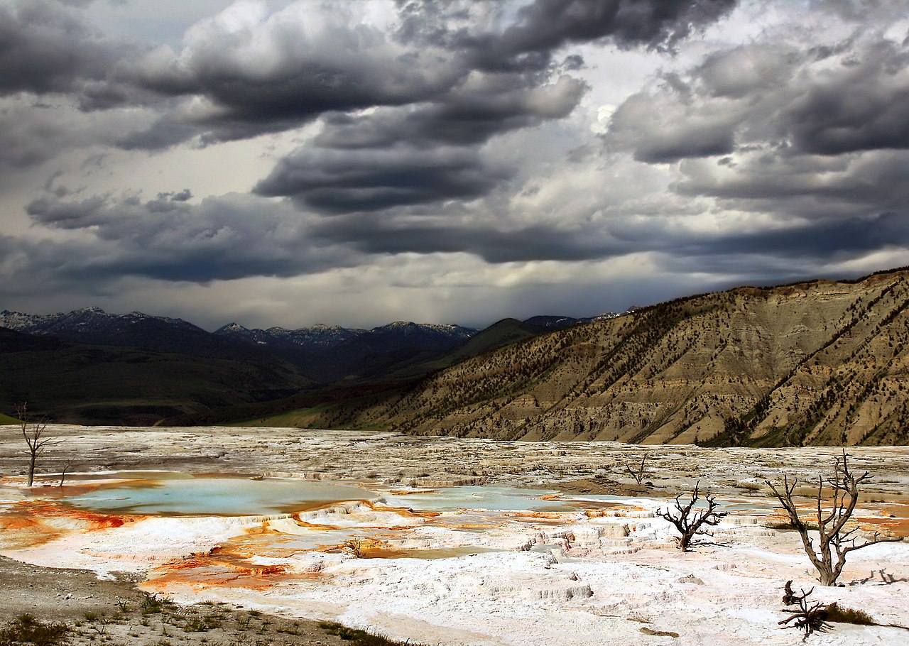
English: Hot water is the creative force of the terraces. Even though Mammoth Hot Springs lie north of the caldera ring-fracture system, a fault trending north from Norris Geyser Basin, 21 miles (34 km) away, may connect Mammoth Hot Springs to the hot water of that system. A system of small fissures carries water upward to create approximately 50 hot springs in the Mammoth Hot Springs area. Another necessary ingredient for terrace growth is the mineral calcium carbonate. Thick layers of sedimentary limestone, deposited millions of years ago by vast seas, lie beneath the Mammoth area. As ground water seeps slowly downward and laterally, it comes in contact with hot gases charged with carbon dioxide rising from the magma chamber. Some carbon dioxide is readily dissolved in the hot water to form a weak carbonic acid solution. This hot, acidic solution dissolves great quantities of limestone as it works up through the rock layers to the surface hot springs. Once exposed to the open air, some of the carbon dioxide escapes from solution. As this happens, limestone can no longer remain in solution. A solid mineral reforms and is deposited as the travertine that forms the terraces. (The image caption was taken from here.)
Français : Hautes terrasses de Mammoth Hot Springs (Litt. « Les sources chaudes taille mammouth ». Les terrasses (ou plutôt les gours) de Mammoth hot springs ont une origine géologique assez complexe: Le site de Mammoth hot springs ne se trouve pas dans la Caldeira de Yellowstone, mais sur un substrat sédimentaire Calcaire. De l'eau chaude provenant du bassin de Norris situé à 34 km de là circule vers cette zone via un système de failles orientées nord-sud. Cette eau est chargée en Acide carbonique, ce qui lui confère la propriété de dissoudre le calcaire. Lorsque l'eau chaude chargée en calcaire émerge, une partie de l'acide carbonique s'évapore sous forme de dioxyde de carbone, et une partie du calcaire précipite, formant de gigantesques gours. |
| المصدر | عمل شخصي |
| المؤلف | Brocken Inaglory |
| موقع الكاميرا | | هذه وغيرها من الصور في مواقعها على: خريطة الشارع المفتوحة |
|---|
ترخيص
أنا، صاحب حقوق التأليف والنشر لهذا العمل، أنشر هذا العمل تحت الرخص التالية:
هذا الملفُّ مُرخَّص بموجب رخصة المشاع الإبداعي نسبة المُصنَّف إِلى مُؤَلِّفه - المشاركة بالمثل 3.0 العامة
- يحقُّ لك:
- مشاركة العمل – نسخ العمل وتوزيعه وبثُّه
- إعادة إنتاج العمل – تعديل العمل
- حسب الشروط التالية:
- نسب العمل إلى مُؤَلِّفه – يلزم نسب العمل إلى مُؤَلِّفه بشكل مناسب وتوفير رابط للرخصة وتحديد ما إذا أجريت تغييرات. بالإمكان القيام بذلك بأية طريقة معقولة، ولكن ليس بأية طريقة تشير إلى أن المرخِّص يوافقك على الاستعمال.
- الإلزام بترخيص المُشتقات بالمثل – إذا أعدت إنتاج المواد أو غيرت فيها، فيلزم أن تنشر مساهماتك المُشتقَّة عن الأصل تحت ترخيص الأصل نفسه أو تحت ترخيص مُتوافِقٍ معه.

|
يسمح نسخ وتوزيع و/أو تعديل هذه الوثيقة تحت شروط رخصة جنو للوثائق الحرة، الإصدار 1.2 أو أي إصدار لاحق تنشره مؤسسة البرمجيات الحرة؛ دون أقسام ثابتة ودون نصوص أغلفة أمامية ودون نصوص أغلفة خلفية. نسخة من الرخصة تم تضمينها في القسم المسمى GNU Free Documentation License. |
لك أن تختار الرخصة التي تناسبك.
تاريخ الملف
اضغط على زمن/تاريخ لرؤية الملف كما بدا في هذا الزمن.
| زمن/تاريخ | صورة مصغرة | الأبعاد | مستخدم | تعليق | |
|---|---|---|---|---|---|
| حالي | 06:08، 5 أبريل 2009 | | 2٬100 × 1٬493 (2٫17 ميجابايت) | commonswiki>Mbz1 | improved quality |
استخدام الملف
ال1 ملف التالي مكررات لهذا الملف (المزيد من التفاصيل):
- ملف:Upper Terraces of Mammoth Hot Springs.jpg من ويكيميديا كومنز
الصفحة التالية تستخدم هذا الملف: