|
تضامنًا مع حق الشعب الفلسطيني |
ملف:United States Fall Line.jpg
اذهب إلى التنقل
اذهب إلى البحث
لا توجد دقة أعلى متوفرة.
United_States_Fall_Line.jpg (250 × 534 بكسل حجم الملف: 43 كيلوبايت، نوع MIME: image/jpeg)
| هذا ملف من ويكيميديا كومنز. معلومات من صفحة وصفه مبينة في الأسفل. كومنز مستودع ملفات ميديا ذو رخصة حرة. |
ملخص
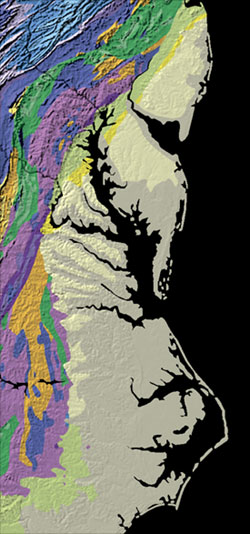
| الوصف | Relief map showing the Fall Line in the Eastern United States |
| التاريخ | |
| المصدر | http://nationalatlas.gov/articles/geology/features/fallline.html |
| المؤلف | The National Atlas of the United States of America |
ترخيص
This map was obtained from an edition of the National Atlas of the United States. Like almost all works of the U.S. federal government, works from the National Atlas are in the public domain in the United States.
Online access: NationalAtlas.gov | 1970 print edition: Library of Congress, Perry-Castañeda Library
|
تاريخ الملف
اضغط على زمن/تاريخ لرؤية الملف كما بدا في هذا الزمن.
| زمن/تاريخ | صورة مصغرة | الأبعاد | مستخدم | تعليق | |
|---|---|---|---|---|---|
| حالي | 14:29، 29 مارس 2009 | | 250 × 534 (43 كيلوبايت) | commonswiki>Yassie | {{Information |Description=Relief map showing the Fall Line in the Eastern United States |Source=http://nationalatlas.gov/articles/geology/features/fallline.html |Date= |Author=The National Atlas of the United States of America |Permission= |other_version |
استخدام الملف
ال1 ملف التالي مكررات لهذا الملف (المزيد من التفاصيل):
- ملف:United States Fall Line.jpg من ويكيميديا كومنز
الصفحة التالية تستخدم هذا الملف: