|
تضامنًا مع حق الشعب الفلسطيني |
ملف:Sweden CIA map extended.gif
الملف الأصلي (300 × 714 بكسل حجم الملف: 21 كيلوبايت، نوع MIME: image/gif)
| هذا ملف من ويكيميديا كومنز. معلومات من صفحة وصفه مبينة في الأسفل. كومنز مستودع ملفات ميديا ذو رخصة حرة. |
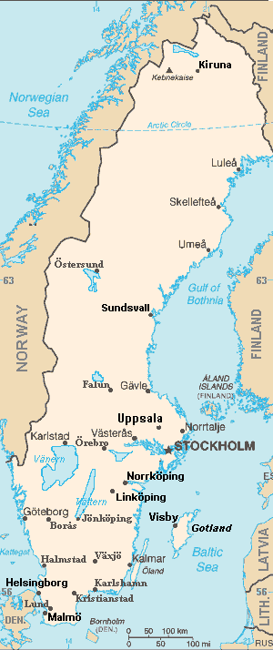
ملخص
| الوصف |
Map of Sweden, extended from CIA World Fact Book, showing largest cities, islands and lake names. Larger city names (10) have been labeled with font-face Arial or Arial Narrow, as font-size 9 or 10; the island/region names are labeled in italic font. Sweden contains over 200 towns, but they are evenly dispersed around the main southern towns, except near Copenhagen, which has very high density. This map has locator code "SwedenCIAx" for use in map-locator templates, such as English Wiki Template:Location_map_SwedenCIAx & Template:Location_map_skew (which skews northern coordinates for multiple map markers/labels). The latitude/longitude coordinates are not equirectangular, but rather, narrow at the north, with longitudes about 38% closer together at the top. The narrowing longitudes provide more accurate mapping of area and distance than with rectangular coordinates. The original map image was public domain; the following modifications have been made to the original:
|
| التاريخ | |
| المصدر | Derivative of map from User:Fred_J changing CIA map (Wikimedia Commons): Image:Sweden from cia.png (adding 10 labels, restoring color to CIA hues & magnified 15%) |
| المؤلف | Wikid77 (derivative of User:Fred_J form of CIA map, adding 10 labels) |
| إصدارات أخرى |
This map has some variations:
|
ترخيص
- يحقُّ لك:
- مشاركة العمل – نسخ العمل وتوزيعه وبثُّه
- إعادة إنتاج العمل – تعديل العمل
- حسب الشروط التالية:
- نسب العمل إلى مُؤَلِّفه – يلزم نسب العمل إلى مُؤَلِّفه بشكل مناسب وتوفير رابط للرخصة وتحديد ما إذا أجريت تغييرات. بالإمكان القيام بذلك بأية طريقة معقولة، ولكن ليس بأية طريقة تشير إلى أن المرخِّص يوافقك على الاستعمال.
- الإلزام بترخيص المُشتقات بالمثل – If you alter, transform, or build upon this work, you must distribute the resulting work under the same license as the original.
تقع هذه الصُّورة في النِّطاق العامِّ لأنها تتضمَّن مواد مأخوذةً من كتاب حقائق العالم الَّذي تصدره وكالة الاستخبارات المركزيَّة في الولايات المُتَّحدة الأمريكيَّة.
|
 |
Format

This file is purposely maintained in GIF format (most international GIF-related patents have expired) for compatibility with the original CIA maps. Semi-automatic conversions to PNG-format might lose the color hues of the CIA maps, tending to shift to lighter blue and shift beige to white. A larger, detailed version of the map is being expanded, with more of the smaller 200 towns added.
تاريخ الملف
اضغط على زمن/تاريخ لرؤية الملف كما بدا في هذا الزمن.
| زمن/تاريخ | صورة مصغرة | الأبعاد | مستخدم | تعليق | |
|---|---|---|---|---|---|
| حالي | 22:44، 5 سبتمبر 2007 | | 300 × 714 (21 كيلوبايت) | commonswiki>Wikid77 | completed east border of Sweden; enlarged "Helsingborg" & "Malmo" etc. |
استخدام الملف
ال1 ملف التالي مكررات لهذا الملف (المزيد من التفاصيل):
- ملف:Sweden CIA map extended.gif من ويكيميديا كومنز
الصفحة التالية تستخدم هذا الملف: