|
تضامنًا مع حق الشعب الفلسطيني |
ملف:Spread of Christianity to AD 600 - Atlas of World History.png
اذهب إلى التنقل
اذهب إلى البحث

حجم هذه المعاينة: 800 × 592 بكسل. الأبعاد الأخرى: 320 × 237 بكسل | 640 × 474 بكسل | 1٬024 × 758 بكسل | 1٬280 × 948 بكسل | 2٬187 × 1٬619 بكسل.
الملف الأصلي (2٬187 × 1٬619 بكسل حجم الملف: 227 كيلوبايت، نوع MIME: image/png)
| هذا ملف من ويكيميديا كومنز. معلومات من صفحة وصفه مبينة في الأسفل. كومنز مستودع ملفات ميديا ذو رخصة حرة. |
ملخص
| الوصف |
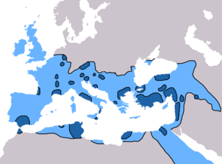
English: Map of the spread of Christianity in Europe, Southwest Asia and North Africa to the year AD 600.
"redominantly Christian by AD 325" zone coloured in dark blue, "Predominantly Christian by AD 600" coloured in light blue.
Predominantly Christian by AD 325
Predominantly Christian by AD 600
Magyar: A kereszténység elterjedése:
Kr. u. 325-ig
325 és 600 között
Information obtained from Patrick O'Brien , ed. (٢٠٠٣) Atlas of World History، تصنيف:نيويورك: Oxford University Press، pp. 44−5 0-19-521921-X Map created and uploaded in the English Wikipedia by Geuiwogbil. Base map: "File:BlankMap-Europe-v3.png" |
| التاريخ | ٢٧ مايو ٢٠٠٩ (تاريخ الرفع الأصيل) |
| المصدر | نُقِلت من en.wikipedia إلى كُومُنز بواسطة QuartierLatin1968 باستخدام CommonsHelper. |
| المؤلف | Geuiwogbil في ويكيبيديا الإنجليزية |

|
هذه religion map الصورة / الصورتان باستعمال رسومات متجهية ملفات رسوميات شعاعية.
It is recommended to name the SVG file "Spread of Christianity to AD 600 - Atlas of World History.svg" - then the template Vector version available (or Vva) does not need the new image name parameter.
|
ترخيص
Geuiwogbil من en.wikipedia.org، صاحب حقوق التأليف والنشر لهذا العمل، أنشر هذا العمل تحت الرخصة التالية:
| هذا الملفُّ مُرخَّص بموجب رخصة المشاع الإبداعي نسبة المُصنَّف إِلى مُؤَلِّفه - المشاركة بالمثل 3.0 العامة Subject to disclaimers. | ||
| نسب العمل لمُؤَلِّفه: Geuiwogbil من en.wikipedia.org | ||
| ||
| تمت إضافة علامة الترخيص لهذا الملف كجزء من رخصة جنو للوثائق الحرة تحديث الترخيص. |

|
يسمح نسخ وتوزيع و/أو تعديل هذه الوثيقة تحت شروط رخصة جنو للوثائق الحرة، الإصدار 1.2 أو أي إصدار لاحق تنشره مؤسسة البرمجيات الحرة؛ دون أقسام ثابتة ودون نصوص أغلفة أمامية ودون نصوص أغلفة خلفية. نسخة من الرخصة تم تضمينها في القسم المسمى GNU Free Documentation License. Subject to disclaimers. |
سجلُّ الرَّفع الأصيل
صفحة الوصف الأصلية كانت هنا، تشير جميع أسماء المستخدمين التالية إلى en.wikipedia.
- 2009-05-27 19:20 Carlaude 2187×1619× (232587 bytes) Cutting out unused areas of the map
- 2006-09-09 02:34 Geuiwogbil 2285×2181× (248280 bytes) Blue provides us with a better constrast.
- 2006-09-04 05:10 Geuiwogbil 2285×2181× (254524 bytes)
- 2006-09-04 05:08 Geuiwogbil 2285×2181× (116034 bytes) Map of the spread of Christianity in Europe, Southwest Asia and North Africa to the year 600 AD. Base map "BlankMap-Europe-v.3." Spread of Christianity to AD 325 coloured in orange, to 600 coloured in yellow. Information obtained from {{cite book |editor=
تاريخ الملف
اضغط على زمن/تاريخ لرؤية الملف كما بدا في هذا الزمن.
| زمن/تاريخ | صورة مصغرة | الأبعاد | مستخدم | تعليق | |
|---|---|---|---|---|---|
| حالي | 21:31، 3 يونيو 2022 | | 2٬187 × 1٬619 (227 كيلوبايت) | commonswiki>Veverve | Reverted to version as of 10:19, 4 July 2021 (UTC) please bring a map source to counter this claim that only part of Armenia etc. were partially christianised |
استخدام الملف
ال1 ملف التالي مكررات لهذا الملف (المزيد من التفاصيل):
- ملف:Spread of Christianity to AD 600 - Atlas of World History.png من ويكيميديا كومنز
ال7 صفحات التالية تستخدم هذا الملف: