|
تضامنًا مع حق الشعب الفلسطيني |
ملف:Sault Ste Marie, Ontario and Michigan.JPG
اذهب إلى التنقل
اذهب إلى البحث

حجم هذه المعاينة: 398 × 599 بكسل. الأبعاد الأخرى: 159 × 240 بكسل | 319 × 480 بكسل | 510 × 768 بكسل | 680 × 1٬024 بكسل | 1٬360 × 2٬048 بكسل | 2٬848 × 4٬288 بكسل.
الملف الأصلي (2٬848 × 4٬288 بكسل حجم الملف: 8٫47 ميجابايت، نوع MIME: image/jpeg)
| هذا ملف من ويكيميديا كومنز. معلومات من صفحة وصفه مبينة في الأسفل. كومنز مستودع ملفات ميديا ذو رخصة حرة. |
ملخص
| الوصف |
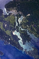
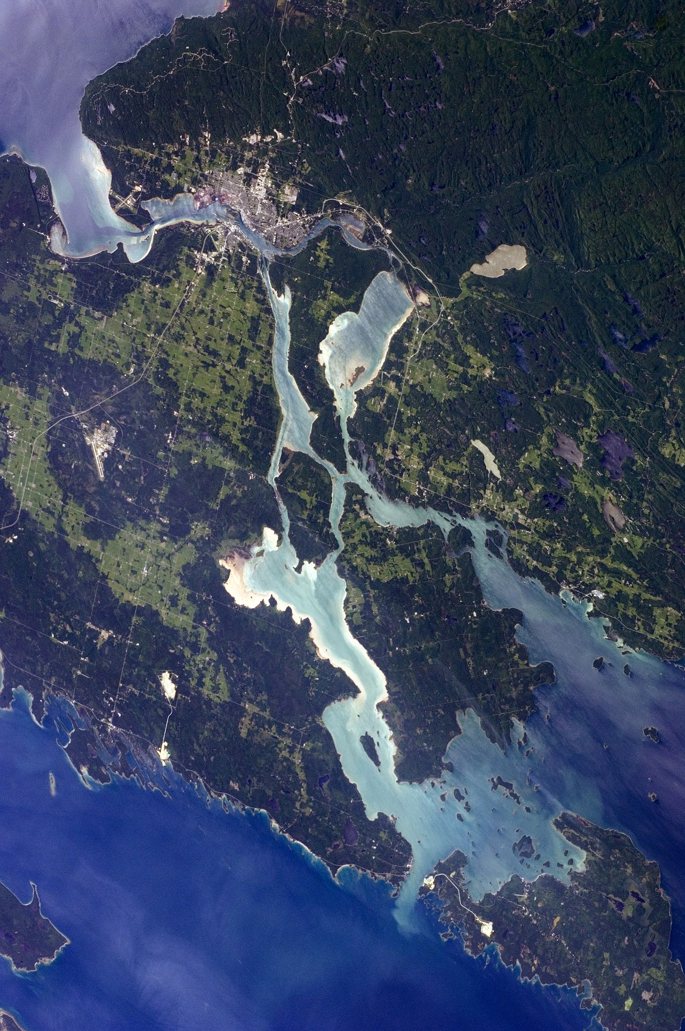
English: The twin cities of Sault Ste Marie are located across the St. Mary’s River, which forms part of the international boundary between Canada (Province of Ontario) and the United States (State of Michigan). This astronaut photograph highlights the two cities, as well as the lakes and islands that separate Lakes Huron and Superior, two of the Great Lakes of North America. Smaller lakes include Lake George to the west, and the large forested islands of St. Joseph and Drummond are visible at image upper left.
The Sault Ste Marie urban areas (image lower left) have a distinctive gray to white colour, contrasting with the deep green of forested areas in Ontario and the lighter green of agricultural fields in Michigan. The water surfaces in the lakes and rivers vary from blue to blue-green to silver, likely the result of varying degrees of sediment and sunglint—light reflecting from the water surface back to the International Space Station. |
| التاريخ | |
| المصدر | NASA Earth Observatory |
| المؤلف | ISS Expedition 28 crew |
| موقع آلة التصوير | | هذه وغيرها من الصور في مواقعها على: خريطة الشارع المفتوحة |
|---|
فُهرِست هذه الصُّورة أَو هذا التَّسجيل المرئي لدى مركز جونسون للفضاء التَّابعة لوكالة الفضاء الأَمريكيَّة (ناسا) تحت المُعرِّف ISS028-E-10162. لا يُشير هذه الوَسم إلى حالة حقوق التَّأليف والنَّشر الخاصَّة بالعمل المُرفَق؛ لا يزال وَسم حقوق التَّأليف والنَّشر مَطلُوباً، راجع كومنز:ترخيص لمزيدٍ من المعلومات. لغات أخرى:
|
Image acquired with a Nikon D2Xs digital camera using a 110 mm lens, and is provided by the ISS Crew Earth Observations experiment and Image Science & Analysis Laboratory, Johnson Space Center.
ترخيص
| يقع هذا العمل في النِّطاق العامّ في الولايات المُتحدة الأمريكيَّة لأَنَّه عملٌ خالِصٌ من إِنتاج وكالة الفضاء الأمريكيَّة. تنصُ حقوق التَّأليف والنَّشر الخاصَّة بوكالة الفضاء الأمريكيَّة على أنَّ "أعمال الوكالة غير مَحميَّة بحقوق التَّأليف والنَّشر ما لم يُذكر خلافُ ذلك". لمزيدٍ من المعلومات انظر القالِب {{PD-USGov}} وصفحة حقوق التَّأليف والنَّشر الخاصَّة بالوكالة وصفحة سياسة الصُّور الخاصَّة بمُختبر الدَّفع النَّفَّاث. | ||
 |
تنبيهات:
|
| الشروح | هذه الصورة مشروحة: أظهر الشروح في كومنز |
تاريخ الملف
اضغط على زمن/تاريخ لرؤية الملف كما بدا في هذا الزمن.
| زمن/تاريخ | صورة مصغرة | الأبعاد | مستخدم | تعليق | |
|---|---|---|---|---|---|
| حالي | 16:12، 18 أغسطس 2018 | | 2٬848 × 4٬288 (8٫47 ميجابايت) | commonswiki>Ras67 | new rendered from NASA's raw image date with real quality and without clipped highlights |
استخدام الملف
ال1 ملف التالي مكررات لهذا الملف (المزيد من التفاصيل):
- ملف:Sault Ste Marie, Ontario and Michigan.JPG من ويكيميديا كومنز
الصفحة التالية تستخدم هذا الملف: