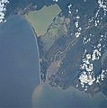
ملف:Rio magdalena mundung.JPG

من أرابيكا، الموسوعة الحرة
اذهب إلى التنقل اذهب إلى البحث

الملف الأصلي(4٬064 × 4٬096 بكسل حجم الملف: 849 كيلوبايت، نوع MIME: image/jpeg)

ملخص

الوصف
Deutsch: Eine Satellitenaufnahme der Mündung des Rio Magdalenas (unten). An der Mündung ist auch die Großstadt Barranquilla zu sehen. Das Süßwasser des Rio Magdalenas ist deutlich zu sehen. Das Süßwasser wäre noch kilometerweit zu sehen, wenn das Bild größer wäre. Die Bucht oben (dunkles Wasser) ist das Sumpfgebiet Ciénaga Grande de Santa Marta. Das Große Meer, an dem die Bucht und der Fluss liegt, ist das Karibische Meer.
English: Magdalena River delta

Barranquilla, Magdalena River Mouth, Colombia
The mouth of the sediment-laden Magdalena River and Colombia’s chief port, Barranquilla, can be seen in this south-southeast-looking view. The river’s sediment plume extends many miles out into the southwest Caribbean Sea (bottom half of the image). The Magdalena links the interior highlands with the coastal lowlands of Colombia. Barranquilla with a population of well over a million people, is located on the west bank of the river, and has large chemical factories and cement works, along with shipbuilding and textile facilities.

  • Identification
  • Mission: ISS002 Roll: 732 Frame: 73 Mission ID on the Film or image: ISS002
  • Country or Geographic Name: COLOMBIA
  • Features: BARRANQUILLA
  • Center Point Latitude: 11.0 Center Point Longitude: -74.5 (Negative numbers indicate south for *latitude and west for longitude)
  • Stereo: (Yes indicates there is an adjacent picture of the same area)
  • ONC Map ID: JNC Map ID:
  • Camera
  • Camera Tilt:
  • Camera Focal Length: 250mm
  • Camera: HB: Hasselblad
  • Film: 5069 : Kodak Elite 100S, E6 Reversal, Replaces Lumiere, Warmer in tone vs. Lumiere.
  • Quality
  • Film Exposure:
  • Percentage of Cloud Cover: 25 (11-25)
  • Nadir
  • Date: 20010810 (YYYYMMDD)GMT Time: 19____ (HHMMSS)
  • Nadir Point Latitude: , Longitude: (Negative numbers indicate south for latitude and west for longitude)
  • Nadir to Photo Center Direction:
  • Sun Azimuth: (Clockwise angle in degrees from north to the sun measured at the nadir point)
  • Spacecraft Altitude: nautical miles (0 km)
  • Sun Elevation Angle: (Angle in degrees between the horizon and the sun, measured at the nadir point)
  • Orbit Number:
التاريخ
المصدر http://earth.jsc.nasa.gov/scripts/sseop/photo.pl?mission=ISS002&roll=732&frame=73
المؤلف NASA
فُهرِست هذه الصُّورة أَو هذا التَّسجيل المرئي لدى مركز جونسون للفضاء التَّابعة لوكالة الفضاء الأَمريكيَّة (ناسا)   تحت المُعرِّف ISS002-732-73.

لا يُشير هذه الوَسم إلى حالة حقوق التَّأليف والنَّشر الخاصَّة بالعمل المُرفَق؛ لا يزال وَسم حقوق التَّأليف والنَّشر مَطلُوباً، راجع كومنز:ترخيص لمزيدٍ من المعلومات.
لغات أخرى:

ترخيص

Public domain
يقع هذا الملفُّ في النِّطاق العامِّ في الولايات المُتحدة لأنَّه أُنشِئ مِن قبل مُختبر علوم الصُّور وتحليلها في مركز جُونسُون للفضاء التَّابِع لوَكالة الفضاء الأَمريكيَّة. تنصُّ سياسة حقوق التَّأليف والنَّشر لوَكالة الفضاء الأَمريكيَّة على أنَّ "المواد الَّتي تُنتجها الوَكالة غير مَحميَّةٍ بحقوق التَّأليف والنَّشر ما لم يُذكر خلاف ذلك". انظر (دليل استعمال الوسائِط الخاصِّ بالوَكالة أو شروط استعمال الصُّور الضُّوئِيَّة التي التقطها روَّاد الفضاء). مَصدَر الصُّورة: ISS002-732-73.

العربيَّة | Deutsch | English | español | français | italiano | kurdî | македонски | മലയാളം | português | sicilianu | +/−

سجلُّ الرَّفع الأصيل

نُقِلت من de.wikipedia إلى كُومُنز بواسطة Ireas باستخدام CommonsHelper.

صفحة الوصف الأصلية كانت هنا، تشير جميع أسماء المستخدمين التالية إلى de.wikipedia.
  • 2004-08-22 18:36 4tilden 515×512× (34041 bytes) Mündung des Rio Magdalenas

الشروحات

أضف شرحاً من سطر واحد لما يُمثِّله هذا الملف

العناصر المصورة في هذا الملف

يُصوِّر

١٠ أغسطس 2001

تاريخ الملف

اضغط على زمن/تاريخ لرؤية الملف كما بدا في هذا الزمن.

زمن/تاريخصورة مصغرةالأبعادمستخدمتعليق
حالي00:19، 15 أغسطس 2011تصغير للنسخة بتاريخ 00:19، 15 أغسطس 20114٬064 × 4٬096 (849 كيلوبايت)commonswiki>Ras67cropped from the high resolution original

ال1 ملف التالي مكررات لهذا الملف (المزيد من التفاصيل):

الصفحة التالية تستخدم هذا الملف:

بيانات وصفية