|
تضامنًا مع حق الشعب الفلسطيني |
ملف:Puyallup.png
اذهب إلى التنقل
اذهب إلى البحث

حجم هذه المعاينة: 800 × 574 بكسل. الأبعاد الأخرى: 320 × 230 بكسل | 640 × 459 بكسل | 1٬024 × 735 بكسل | 1٬280 × 919 بكسل | 1٬592 × 1٬143 بكسل.
الملف الأصلي (1٬592 × 1٬143 بكسل حجم الملف: 3٫29 ميجابايت، نوع MIME: image/png)
| هذا ملف من ويكيميديا كومنز. معلومات من صفحة وصفه مبينة في الأسفل. كومنز مستودع ملفات ميديا ذو رخصة حرة. |
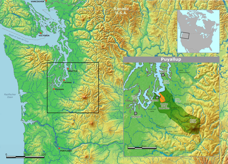
| الوصف | Map of traditional Puyallup tribal territory. | ||||
| التاريخ | |||||
| المصدر | Own work by Nikater, submitted to the public domain. Background map courtesy of Demis, www.demis.nl | ||||
| المؤلف | User:Nikater | ||||
| الترخيص (إعادة استخدام هذا الملف) |
|
تاريخ الملف
اضغط على زمن/تاريخ لرؤية الملف كما بدا في هذا الزمن.
| زمن/تاريخ | صورة مصغرة | الأبعاد | مستخدم | تعليق | |
|---|---|---|---|---|---|
| حالي | 12:23، 2 مايو 2011 | | 1٬592 × 1٬143 (3٫29 ميجابايت) | commonswiki>Nikater | Ausschnitt der kleinen Karte eingefügt |
استخدام الملف
ال1 ملف التالي مكررات لهذا الملف (المزيد من التفاصيل):
- ملف:Puyallup.png من ويكيميديا كومنز
الصفحة التالية تستخدم هذا الملف: