|
تضامنًا مع حق الشعب الفلسطيني |
ملف:Prohibited Area P-40 Camp David.png
اذهب إلى التنقل
اذهب إلى البحث
حجم هذه المعاينة: 800 × 574 بكسل. الأبعاد الأخرى: 320 × 230 بكسل | 640 × 459 بكسل | 1٬002 × 719 بكسل.
الملف الأصلي (1٬002 × 719 بكسل حجم الملف: 408 كيلوبايت، نوع MIME: image/png)
| هذا ملف من ويكيميديا كومنز. معلومات من صفحة وصفه مبينة في الأسفل. كومنز مستودع ملفات ميديا ذو رخصة حرة. |
| الوصف |
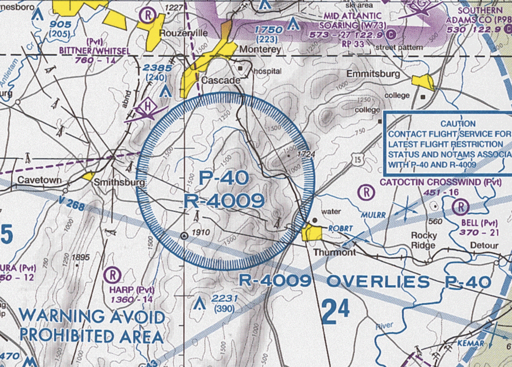
English: Section of VFR Terminal Area Raster Aeronautical Chart Baltimore/Washington, 84th edition, showing the prohibited area P-40 and restricted area R-4009 around Camp David Note: This map is valid until ٢٦ يوليو ٢٠١٢. For navigational purposes, be sure to get the newest edition at the official FAA website |
| التاريخ |
|
| المصدر | Baltimore-Washington_TAC_84.tif in Baltimore-Washington_TAC_84.zip. Note: The ZIP-File may become unavailable when the map is updated, newer editions will be available here |
| المؤلف | US Department of Transportation, Federal Aviation Administration, National Aeronautical Navigation Services |
| إصدارات أخرى |
This image or file is a work of a Federal Aviation Administration employee, taken or made as part of that person's official duties. As a work of the U.S. federal government, the image is in the public domain in the United States.
|
 |
تاريخ الملف
اضغط على زمن/تاريخ لرؤية الملف كما بدا في هذا الزمن.
| زمن/تاريخ | صورة مصغرة | الأبعاد | مستخدم | تعليق | |
|---|---|---|---|---|---|
| حالي | 19:34، 24 مايو 2012 | | 1٬002 × 719 (408 كيلوبايت) | commonswiki>El Grafo | update |
استخدام الملف
ال1 ملف التالي مكررات لهذا الملف (المزيد من التفاصيل):
- ملف:Prohibited Area P-40 Camp David.png من ويكيميديا كومنز
الصفحة التالية تستخدم هذا الملف: