|
تضامنًا مع حق الشعب الفلسطيني |
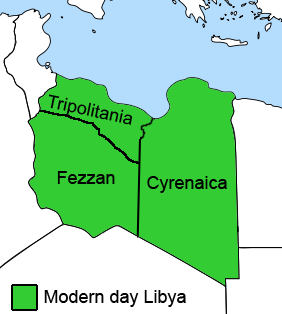
ملف:Ottoman Provinces Of Present day Libya.png
اذهب إلى التنقل
اذهب إلى البحث
لا توجد دقة أعلى متوفرة.
Ottoman_Provinces_Of_Present_day_Libya.png (282 × 314 بكسل حجم الملف: 22 كيلوبايت، نوع MIME: image/png)
| هذا ملف من ويكيميديا كومنز. معلومات من صفحة وصفه مبينة في الأسفل. كومنز مستودع ملفات ميديا ذو رخصة حرة. |

|
هذه locator map الصورة / الصورتان باستعمال رسومات متجهية ملفات رسوميات شعاعية.
It is recommended to name the SVG file "Ottoman Provinces Of Present day Libya.svg" - then the template Vector version available (or Vva) does not need the new image name parameter.
|
ملخص
| الوصف |
English: The Ottoman Turks conquered the country in the mid-16th century, and the three States or "Wilayat" of Tripolitania, Cyrenaica and Fezzan (which make up Libya) remained part of their empire with the exception of the virtual autonomy of the Karamanlis. The Karamanlis ruled from 1711 until 1835 mainly in Tripolitania, but had influence in Cyrenaica and Fezzan as well by the mid 18th century. |
||
| التاريخ | |||
| المصدر | self-made but based on this image on this image and this image | ||
| المؤلف | Esemono; improved by Kirk (talk) | ||
| الترخيص (إعادة استخدام هذا الملف) |
|
||
| إصدارات أخرى |
أَعمالٌ مُشتقَّة مِن هذا الملفِّ:
   |
تاريخ الملف
اضغط على زمن/تاريخ لرؤية الملف كما بدا في هذا الزمن.
| زمن/تاريخ | صورة مصغرة | الأبعاد | مستخدم | تعليق | |
|---|---|---|---|---|---|
| حالي | 16:53، 24 أغسطس 2011 | | 282 × 314 (22 كيلوبايت) | commonswiki>Kirk979 | See discussion |
استخدام الملف
ال1 ملف التالي مكررات لهذا الملف (المزيد من التفاصيل):
- ملف:Ottoman Provinces Of Present day Libya.png من ويكيميديا كومنز
ال9 صفحات التالية تستخدم هذا الملف: