|
تضامنًا مع حق الشعب الفلسطيني |
ملف:NUTS 3 regions of Northern Ireland map.svg
اذهب إلى التنقل
اذهب إلى البحث

حجم معاينة PNG لذلك الملف ذي الامتداد SVG: 705 × 599 بكسل. الأبعاد الأخرى: 282 × 240 بكسل | 565 × 480 بكسل | 903 × 768 بكسل | 1٬205 × 1٬024 بكسل | 2٬409 × 2٬048 بكسل | 1٬208 × 1٬027 بكسل.
الملف الأصلي (ملف SVG، أبعاده 1٬208 × 1٬027 بكسل، حجم الملف: 163 كيلوبايت)
| هذا ملف من ويكيميديا كومنز. معلومات من صفحة وصفه مبينة في الأسفل. كومنز مستودع ملفات ميديا ذو رخصة حرة. |
ملخص
| الوصف |
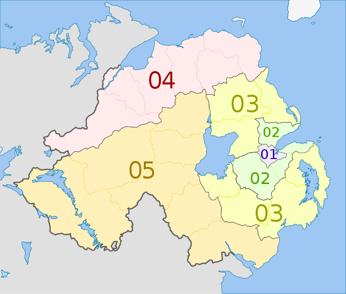
Deutsch: Karte von Nordirland: NUTS-Raumeinheiten auf den Ebenen NUTS3.
Quadratische Plattkarte, N-S-Streckung 170 %. Geographische Begrenzung der Karte:
English: Map of the NUTS 3 regions of Northern Ireland.
Equirectangular projection, N/S stretching 170 %. Geographic limits of the map:
|
| التاريخ | (UTC) |
| المصدر |
هذا الملفُّ مُشتقٌ مِن: Northern Ireland location map.svg: |
| المؤلف |
|
| NUTS 1 | Code | NUTS 2 | Code | NUTS 3 | Code |
|---|---|---|---|---|---|
| Northern Ireland | UKN | Northern Ireland | UKN0 | Belfast | UKN01 |
| Outer Belfast (Carrickfergus, Castlereagh, Lisburn, Newtownabbey, North Down) | UKN02 | ||||
| East of Northern Ireland (Antrim, Ards, Ballymena, Banbridge, Craigavon, Down, Larne) | UKN03 | ||||
| North of Northern Ireland (Ballymoney, Coleraine, Derry, Limavady, Moyle, Strabane) | UKN04 | ||||
| West and South of Northern Ireland (Armagh, Cookstown, Dungannon, Fermanagh, Magherafelt, Newry and Mourne, Omagh) | UKN05 |
ترخيص
أنا، صاحب حقوق التأليف والنشر لهذا العمل، أنشر هذا العمل تحت الرخصة التالية:
هذا الملفُّ مُرخَّص بموجب رخصة المشاع الإبداعي نسبة المُصنَّف إِلى مُؤَلِّفه - المشاركة بالمثل 3.0 العامة
نسب العمل لمُؤَلِّفه: Dr Greg and NordNordWest
- يحقُّ لك:
- مشاركة العمل – نسخ العمل وتوزيعه وبثُّه
- إعادة إنتاج العمل – تعديل العمل
- حسب الشروط التالية:
- نسب العمل إلى مُؤَلِّفه – يلزم نسب العمل إلى مُؤَلِّفه بشكل مناسب وتوفير رابط للرخصة وتحديد ما إذا أجريت تغييرات. بالإمكان القيام بذلك بأية طريقة معقولة، ولكن ليس بأية طريقة تشير إلى أن المرخِّص يوافقك على الاستعمال.
- الإلزام بترخيص المُشتقات بالمثل – إذا أعدت إنتاج المواد أو غيرت فيها، فيلزم أن تنشر مساهماتك المُشتقَّة عن الأصل تحت ترخيص الأصل نفسه أو تحت ترخيص مُتوافِقٍ معه.
سجلُّ الرَّفع الأصيل
This image is a derivative work of the following images:
- File:Northern_Ireland_location_map.svg licensed with Cc-by-sa-3.0
- 2009-09-22T18:02:38Z NordNordWest 1208x1027 (166284 Bytes)
- 2009-07-04T20:14:31Z NordNordWest 1208x1027 (167876 Bytes)
- 2009-07-04T20:10:20Z NordNordWest 1208x1027 (167239 Bytes) {{Information |Description= {{de|Positionskarte von [[:de:Nordirland|Nordirland]]}} Quadratische Plattkarte, N-S-Streckung 170 %. Geographische Begrenzung der Karte: * N: 55.4° N * S: 53.9° N * W: 8.3° W * O: 5.3° W {{en|
Uploaded with derivativeFX
تاريخ الملف
اضغط على زمن/تاريخ لرؤية الملف كما بدا في هذا الزمن.
| زمن/تاريخ | صورة مصغرة | الأبعاد | مستخدم | تعليق | |
|---|---|---|---|---|---|
| حالي | 04:20، 5 يونيو 2012 | | 1٬208 × 1٬027 (163 كيلوبايت) | commonswiki>Dr Greg | == {{int:filedesc}} == {{Information |Description={{de|Karte von Nordirland: de:NUTS-Raumeinheiten auf den Ebenen NUTS3. Quadratische Plattkarte, N-S-Streckung 170 %. Geographische Begrenzung der Karte: * N: 55.4° N * S: ... |
استخدام الملف
ال1 ملف التالي مكررات لهذا الملف (المزيد من التفاصيل):
- ملف:NUTS 3 regions of Northern Ireland map.svg من ويكيميديا كومنز
الصفحة التالية تستخدم هذا الملف: