ملف:Nürburgring - Grand-Prix-Strecke.svg

حجم معاينة PNG لذلك الملف ذي الامتداد SVG: 800 × 473 بكسل. الأبعاد الأخرى: 320 × 189 بكسل | 640 × 378 بكسل | 1٬024 × 605 بكسل | 1٬280 × 757 بكسل | 2٬560 × 1٬514 بكسل | 920 × 544 بكسل.
الملف الأصلي (ملف SVG، أبعاده 920 × 544 بكسل، حجم الملف: 82 كيلوبايت)
| هذا ملف من ويكيميديا كومنز. معلومات من صفحة وصفه مبينة في الأسفل. كومنز مستودع ملفات ميديا ذو رخصة حرة. |
ملخص
| الوصف | |
| التاريخ | |
| المصدر | عمل شخصي |
| المؤلف | Will Pittenger |
| إصدارات أخرى |
|

| موقع آلة التصوير | | هذه وغيرها من الصور في مواقعها على: خريطة الشارع المفتوحة |
|---|
Editing note
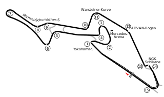
If you need to edit this image, please preserve the hidden layer. It is a backup of the track sections. The visible layer has all track sections stroked to paths so they can have a white border. This allows me to display the image on a dark background if needed. If I get information on the Formula 1 sectors, I will use that backup layer to generate those. I might also need the backup to make any corrections. The exact position of the Mercedes Arena couldn't be located as Google Earth doesn't show it yet.
ترخيص
| أنا، مالِك حقوق تأليف ونشر هذا العمل، أجعله في النِّطاق العامِّ، يسري هذا في أرجاء العالم كلِّه. في بعض البلدان، قد يكون هذا التَّرخيص غيرَ مُمكنٍ قانونيَّاً، في هذه الحالة: أمنح الجميع حق استخدام هذا العمل لأي غرض دون أي شرط ما لم يفرض القانون شروطًا إضافية. |
تاريخ الملف
اضغط على زمن/تاريخ لرؤية الملف كما بدا في هذا الزمن.
| زمن/تاريخ | صورة مصغرة | الأبعاد | مستخدم | تعليق | |
|---|---|---|---|---|---|
| حالي | 03:50، 26 يوليو 2013 | | 920 × 544 (82 كيلوبايت) | commonswiki>Sentoan | Real and correct GP layout, 2013 names of nurburgring's corners |
استخدام الملف
ال1 ملف التالي مكررات لهذا الملف (المزيد من التفاصيل):
- ملف:Nürburgring - Grand-Prix-Strecke.svg من ويكيميديا كومنز
ال9 صفحات التالية تستخدم هذا الملف:
- جائزة ألمانيا الكبرى 2007
- جائزة ألمانيا الكبرى 2009
- جائزة ألمانيا الكبرى 2011
- جائزة ألمانيا الكبرى 2013
- جائزة ألمانيا الكبرى للدراجات النارية 1990
- جائزة ألمانيا الكبرى للدراجات النارية 1995
- جائزة ألمانيا الكبرى للدراجات النارية 1996
- جائزة ألمانيا الكبرى للدراجات النارية 1997
- جائزة أوروبا الكبرى 2006