|
تضامنًا مع حق الشعب الفلسطيني |
ملف:Medieval Arab Palestine.jpg
الملف الأصلي (824 × 1٬064 بكسل حجم الملف: 191 كيلوبايت، نوع MIME: image/jpeg)
| هذا ملف من ويكيميديا كومنز. معلومات من صفحة وصفه مبينة في الأسفل. كومنز مستودع ملفات ميديا ذو رخصة حرة. |
ملخص
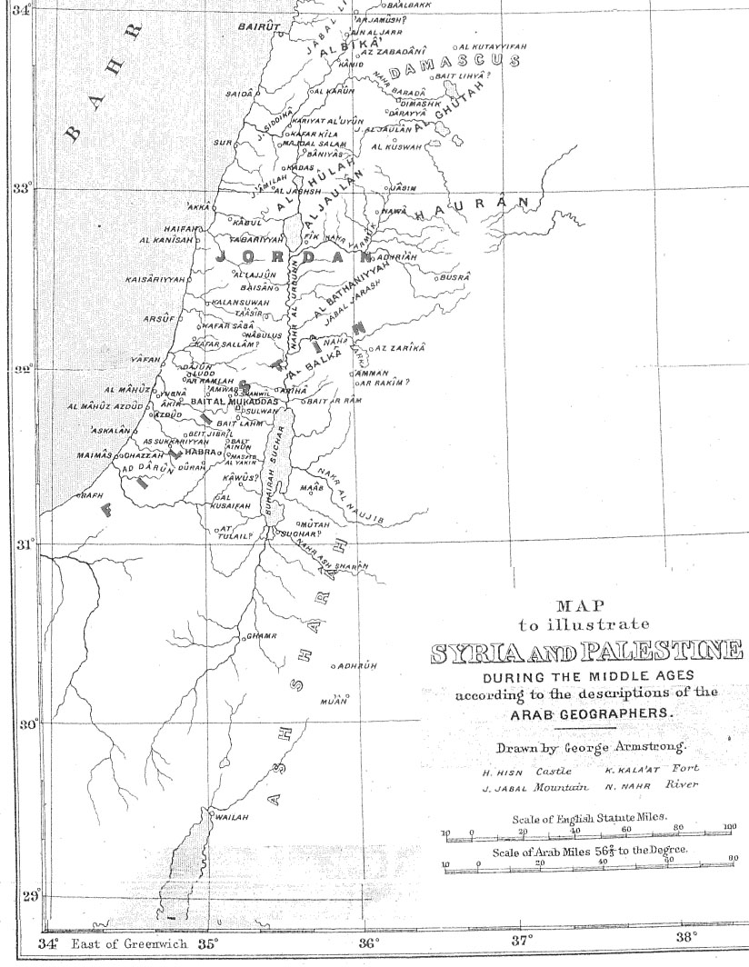
| الوصف | Map of Palestine during the Middle Ages according to the description of the Arab geographers, drawn by Geo. Armstrong, from Palestine Under the Muslims: A Description of Syria and the Holy Land from AD 650 to 1500, by Guy Le Strange, London 1890 |
| التاريخ | ١٦ نوفمبر ٢٠٠٤ (تاريخ الرفع الأصيل) |
| المصدر | نُقِلت من en.wikipedia إلى كُومُنز . |
| المؤلف |
الرَّافِع الأصيل للملفِّ هو Mustafaa في ويكيبيديا الإنجليزية. Later versions were uploaded by AnonMoos at en.wikipedia. |
ترخيص
|
هذا العمل يقع في النَّطاق العامّ في بلد المنشأ وفي البلدان الأخرى والمناطق التي تمتدُّ فيها مدة حقوق التَّأليف والنشر لتغطي زمن حياة المُؤلِّف و 70 سنةً بعد وفاته أو أقل من ذلك. يقع هذ العمل في النَّطاق العامِّ في الولايات المُتحدة الأمريكيَّة لأنَّه نُشِرَ (أو سُجِّل لدى مكتب الولايات المُتحدة لحقوق التَّأليف والنَّشر) قبل ١ يناير ١٩٢٩. | |
| هذا الملفُّ مَلحُوظُ بصفته غيرَ مُقيَّدٍ بحقوق التَّأليف والنشر، وهذا يشمل أيضاً الحقوق المُجاوِرة أَو ذات الصلة جميعُها. | |
سجلُّ الرَّفع الأصيل
- 2005-09-21 17:41 AnonMoos 824×1064×8 (195077 bytes) Losslessly cropped image to area of interest
- 2004-11-16 21:36 Mustafaa 979×1072×8 (218293 bytes) Map of Palestine during the Middle Ages according to the description of the Arab geographers, drawn by Geo. Armstrong, from ''Palestine Under the Muslims: A Description of Syria and the Holy Land from AD 650 to 1500'', by Guy Le Strange, London 1890 (henc
تاريخ الملف
اضغط على زمن/تاريخ لرؤية الملف كما بدا في هذا الزمن.
| زمن/تاريخ | صورة مصغرة | الأبعاد | مستخدم | تعليق | |
|---|---|---|---|---|---|
| حالي | 23:37، 21 يونيو 2007 | | 824 × 1٬064 (191 كيلوبايت) | commonswiki>Friðrik Bragi Dýrfjörð | {{Information |Description=Map of Palestine during the Middle Ages according to the description of the Arab geographers, drawn by Geo. Armstrong, from ''Palestine Under the Muslims: A Description of Syria and the Holy Land from AD 650 to 1500'', by Guy Le |
استخدام الملف
ال1 ملف التالي مكررات لهذا الملف (المزيد من التفاصيل):
- ملف:Medieval Arab Palestine.jpg من ويكيميديا كومنز
الصفحة التالية تستخدم هذا الملف: