|
تضامنًا مع حق الشعب الفلسطيني |
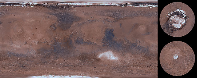
ملف:Mars Viking MDIM21 1km plus poles.jpg

الملف الأصلي (26٬674 × 10٬670 بكسل حجم الملف: 46٫26 ميجابايت، نوع MIME: image/jpeg)
| هذا ملف من ويكيميديا كومنز. معلومات من صفحة وصفه مبينة في الأسفل. كومنز مستودع ملفات ميديا ذو رخصة حرة. |
| تنبيه | تحذير: يمكن لبعض مُتصفحي الإِنترنت أن يواجهوا صعوباتٍ لدى عرض هذه الصُّورة بدقَّتها الكامِلة: لدى هذه الصُّورة عدد ضخم غير اعتيادي مِن النِّقاط، ومِن المُحتمل عدم تحميلها بشكل صحيحٍ في المُتصفِّح الذي قد يتوقف عن العمل نتيجة لذلك. عوضاً عن ذلك، مِن المُستحسن أن تضغط بزرّ الفأرة اليمين على وصلة دقة كاملة وتحفظها على جهازك. عندها يمكن اسخدام برامج خارجية لعرض وتعديل الصورة.
|
|---|
ملخص
| الوصف |
English: This global image map of Mars has a resolution of approximately 1.0 km/pixel at the equator. It is a reduced version of a much larger map with 231 m/pixel resolution at the equator. The colorized mosaic was completed by NASA Ames which warped the original Viking colorized mosaic and blended over the latest black/white mosaic. The full resolution mosaic is known as Colorized Mars Digital Image Model (MDIM) 2.1. MDIM 2.1 replaces two earlier mosaics produced by the USGS from the same set of approximately 4600 Viking Orbiter images. The positional accuracy of features in MDIM 2.1 is estimated to be roughly one pixel (200 m), compared to 3 km for MDIM 2.0 released in 2001 and >6 km for MDIM 1.0 released in 1991. In addition to relatively imprecise geodetic control, the previous mosaics were affected by changing definitions of cartographic parameters (such as the definition of zero longitude), resulting in an overall longitude shift of as much as 0.2° between the early MDIMs and other datasets. The new mosaic uses the most recent coordinate system definitions for Mars. These definitions have been widely adopted by NASA missions and other users of planetary data and are likely to remain in use for a decade or more. As a result, MDIM 2.1 not only registers precisely with data from current missions, such as MGS and 2001 Mars Odyssey, but will serve as an accurate basemap on which data from future missions can be plotted. The images used to make MDIM 2.1 were obtained primarily through the red, clear, and minus-blue filters of the Viking Orbiter imaging system, and thus provide a monochromatic view of Mars weighted toward the red end of the visible spectrum. Images were obtained with a wide range of solar incidence angles. It is unfortunately not possible to correct the appearance of both albedo (reflectivity) variations and topographic features for these incidence angle variations simultaneously. The images have therefore been highpass-filtered at a scale of ~50 km to remove regional albedo variations and then normalized so that equal topographic slopes appear with equal contrast everywhere. Photometric processing for MDIM 2.1 incorporates a model of the transmission and scattering of light in the atmosphere that is substantially improved over that used in MDIM 2.0. Residual tonal mismatches between different images after photometric correction were corrected based on a least-squares adjustment of image brightness and contrast. Because of these photometric and cosmetic improvements, it was possible to use a less severe highpass filter than for MDIM 2.0, improving the overall appearance of the mosaic. The original USGS polar mosaics were increased in size by a linear factor of 1.6 and given margins before being appended to the USGS global mosaic. |
| التاريخ | |
| المصدر | https://astrogeology.usgs.gov/search/details/Mars/Viking/MDIM21/Mars_Viking_MDIM21_ClrMosaic_global_232m/cub |
| المؤلف | NASA / Jet Propulsion Lab / USGS |
| إصدارات أخرى |
|


ترخيص
تقع هذه الصُّورة في النِّطاق االعامِّ في الولايات المُتحدة الأَمريكيَّة لأَنَّها عملٌ أُعدَّ مِن ضابطٍ أَو مُوظَّفٍ في الحكومة الاتحاديَّة للولايات المُتحدة في أَثناء قيامه بواجباته الرَّسميَّة، انظر في البند 17 الفصلَ 1 وفيه القسم 105 من قانون الولايات المُتحدة الأمريكيَّة.
ملاحظة: ينطبق هذا فقط على الأعمال الأصيلة للحكومة الاتحادية وليس على أعمال الولايات أو التبعيات فُرادى ولا على أَيِّ تقسيماتٍ إِداريَّةٍ أُخرى. لا ينطبق هذا القالب أيضاً على على تصاميم الطَّوابع البريديَّة الَّتي نَشرتها الخدمة البريدية للولايات المتحدة منذ العام 1978م. (انظر § 313.6(C)(1) مِن خُلاصة الممارسات العمليَّة لمَكتب حقوق التَّأليف والنَّشر الأمريكية). ولا تَنطبق أَيضاً على بعض قطع النُّقود المعدنيَّة الأَمريكيَّة ;شروط استخدام دار سكِّ العملة الأَمريكيَّة.
|
 | |
| هذا الملفُّ مَلحُوظُ بصفته غيرَ مُقيَّدٍ بحقوق التَّأليف والنشر، وهذا يشمل أيضاً الحقوق المُجاوِرة أَو ذات الصلة جميعُها. | ||
تاريخ الملف
اضغط على زمن/تاريخ لرؤية الملف كما بدا في هذا الزمن.
| زمن/تاريخ | صورة مصغرة | الأبعاد | مستخدم | تعليق | |
|---|---|---|---|---|---|
| حالي | 10:30، 14 مارس 2014 | 26٬674 × 10٬670 (46٫26 ميجابايت) | commonswiki>WolfmanSF | User created page with UploadWizard |
استخدام الملف
ال1 ملف التالي مكررات لهذا الملف (المزيد من التفاصيل):
- ملف:Mars Viking MDIM21 1km plus poles.jpg من ويكيميديا كومنز
الصفحتان التاليتان تستخدمان هذا الملف: