ملف:Mars Map.JPG

من أرابيكا، الموسوعة الحرة
اذهب إلى التنقل اذهب إلى البحث

الملف الأصلي(2٬180 × 1٬244 بكسل حجم الملف: 2٫33 ميجابايت، نوع MIME: image/jpeg)

ملخص

الوصف
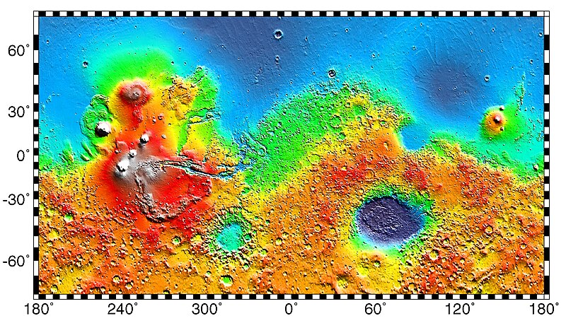
English: PIA02031: Maps of Mars Global Topography - Maps of Mars' global topography. The projections are Mercator to 70° latitude and stereographic at the poles with the south pole at left and north pole at right. Note the elevation difference between the northern and southern hemispheres. The Tharsis volcano-tectonic province is centered near the equator in the longitude range 220° E to 300° E and contains the vast east-west trending Valles Marineris canyon system and several major volcanic shields including Olympus Mons (18° N, 225° E), Alba Patera (42° N, 252° E), Ascraeus Mons (12° N, 248° E), Pavonis Mons (0°, 247° E), and Arsia Mons (9° S, 239° E). Regions and structures discussed in the text include Solis Planum (25° S, 270° E), Lunae Planum (10° N, 290° E), and Claritas Fossae (30° S, 255° E). Major impact basins include Hellas (45° S, 70° E), Argyre (50° S, 320° E), Isidis (12° N, 88° E), and Utopia (45° N, 110° E). This analysis uses an areocentric coordinate convention with east longitude positive.

Color coding on this map of the planet Mars indicates relative elevations based on data from the Mars Orbiter Laser Altimeter on NASA's Mars Global Surveyor. Red is higher elevation (up to +8 km and higher); yellow is 0 km; blue is lower elevation (down to -8 km). In longitude, the map extends from 70 degrees (north) to minus 70 degrees (south). The east-west axis is labeled at the bottom in degrees of east longitude, with the zero meridian at the center.

Data was produced by the Mars Global Surveyor's MOLA instrument

  • Producer ID: P50409 MRPS95009
Português: Mapa de Marte.
Русский: Карта Марса.
التاريخ (released)
المصدر http://photojournal.jpl.nasa.gov/catalog/PIA02031 (image link)
المؤلف NASA/JPL/GSFC
الترخيص
(إعادة استخدام هذا الملف)
https://www.jpl.nasa.gov/imagepolicy/
إصدارات أخرى

Related Templates:

Related Images:

فُهرِست هذه الصُّورة أَو هذا التَّسجيل المرئي لدى Jet Propulsion Laboratory التَّابعة لوكالة الفضاء الأَمريكيَّة (ناسا)   تحت المُعرِّف PIA02031.

لا يُشير هذه الوَسم إلى حالة حقوق التَّأليف والنَّشر الخاصَّة بالعمل المُرفَق؛ لا يزال وَسم حقوق التَّأليف والنَّشر مَطلُوباً، راجع كومنز:ترخيص لمزيدٍ من المعلومات.
لغات أخرى:

ترخيص

Public domain يقع هذا العمل في النِّطاق العامّ في الولايات المُتحدة الأمريكيَّة لأَنَّه عملٌ خالِصٌ من إِنتاج وكالة الفضاء الأمريكيَّة. تنصُ حقوق التَّأليف والنَّشر الخاصَّة بوكالة الفضاء الأمريكيَّة على أنَّ "أعمال الوكالة غير مَحميَّة بحقوق التَّأليف والنَّشر ما لم يُذكر خلافُ ذلك". لمزيدٍ من المعلومات انظر القالِب {{PD-USGov}} وصفحة حقوق التَّأليف والنَّشر الخاصَّة بالوكالة وصفحة سياسة الصُّور الخاصَّة بمُختبر الدَّفع النَّفَّاث.
تنبيهات:

سجلُّ الرَّفع الأصيل

صفحة الوصف الأصلية كانت هنا، تشير جميع أسماء المستخدمين التالية إلى en.wikipedia.
  • 2012-10-26 05:43 Kelvin Case 613×350× (142399 bytes) {{Information |Description= {{en|Map of mars.}} {{pt|Mapa de Marte.}} http://photojournal.jpl.nasa.gov/catalog/PIA02031 PIA02031: Maps of Mars Global Topography Target Name:Mars Is a satellite of:Sol (our sun) Mission: Mars Global Surveyor (MGS) ...

الشروحات

أضف شرحاً من سطر واحد لما يُمثِّله هذا الملف

العناصر المصورة في هذا الملف

يُصوِّر

٢٧ مايو 1999

تاريخ الملف

اضغط على زمن/تاريخ لرؤية الملف كما بدا في هذا الزمن.

زمن/تاريخصورة مصغرةالأبعادمستخدمتعليق
حالي06:57، 4 مايو 2019تصغير للنسخة بتاريخ 06:57، 4 مايو 20192٬180 × 1٬244 (2٫33 ميجابايت)commonswiki>HuntsterFull resolution from NASA/JPL.

ال1 ملف التالي مكررات لهذا الملف (المزيد من التفاصيل):

بيانات وصفية