|
تضامنًا مع حق الشعب الفلسطيني |
ملف:Map showing the Départements of Algeria from 1962-1968 and 1968-1974.svg
اذهب إلى التنقل
اذهب إلى البحث

حجم معاينة PNG لذلك الملف ذي الامتداد SVG: 424 × 600 بكسل. الأبعاد الأخرى: 170 × 240 بكسل | 339 × 480 بكسل | 543 × 768 بكسل | 724 × 1٬024 بكسل | 1٬448 × 2٬048 بكسل | 744 × 1٬052 بكسل.
الملف الأصلي (ملف SVG، أبعاده 744 × 1٬052 بكسل، حجم الملف: 77 كيلوبايت)
| هذا ملف من ويكيميديا كومنز. معلومات من صفحة وصفه مبينة في الأسفل. كومنز مستودع ملفات ميديا ذو رخصة حرة. |
ملخص
| الوصف |
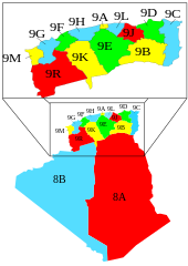
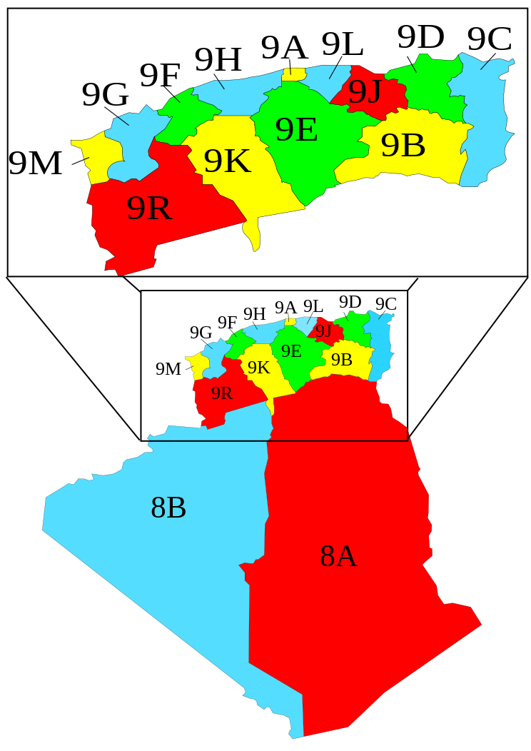
English: A map showing the Départements of Algeria from 1962-1968 and 1968-1974 when they where called "provinces".
Français : Carte des départements français d'Algérie (1957-1962), devenus les départements algériens (1962-1968), renommés wilayas en 1968. |
| التاريخ | |
| المصدر | Image:Algeria_elections_91_by_province.svg by Chabacano |
| المؤلف | Escondites |
Légende
- 8A : Département des Oasis
- 8B : Département de la Saoura
- 9A : Département d'Alger
- 9B : Département de Batna
- 9C : Département de Bône
- 9D : Département de Constantine
- 9E : Département de Médéa
- 9F : Département de Mostaganem
- 9G : Département d'Oran
- 9H : Département d'Orléansville
- 9J : Département de Sétif
- 9K : Département de Tiaret
- 9L : Département de Tizi-Ouzou
- 9M : Département de Tlemcen
- 9R : Département de Saïda
ترخيص
Mustafaa at the English Wikipedia، صاحب حقوق التأليف والنشر لهذا العمل، أنشر هذا العمل تحت الرخصة التالية:

|
يسمح نسخ وتوزيع و/أو تعديل هذه الوثيقة تحت شروط رخصة جنو للوثائق الحرة، الإصدار 1.2 أو أي إصدار لاحق تنشره مؤسسة البرمجيات الحرة؛ دون أقسام ثابتة ودون نصوص أغلفة أمامية ودون نصوص أغلفة خلفية. نسخة من الرخصة تم تضمينها في القسم المسمى GNU Free Documentation License. |
| هذا الملفُّ مُرخَّص بموجب رخصة المشاع الإبداعي نسبة المُصنَّف إِلى مُؤَلِّفه - المشاركة بالمثل 3.0 العامة | ||
| نسب العمل لمُؤَلِّفه: Mustafaa at the English Wikipedia | ||
| ||
| تمت إضافة علامة الترخيص لهذا الملف كجزء من رخصة جنو للوثائق الحرة تحديث الترخيص. |
تاريخ الملف
اضغط على زمن/تاريخ لرؤية الملف كما بدا في هذا الزمن.
| زمن/تاريخ | صورة مصغرة | الأبعاد | مستخدم | تعليق | |
|---|---|---|---|---|---|
| حالي | 15:02، 7 نوفمبر 2007 | | 744 × 1٬052 (77 كيلوبايت) | commonswiki>Escondites | == Summary == {{Information |Description= A map showing the Départements, Algeria from 1962-1968 and 1968-1974 when they where called "provinces". |Source= Image:Algeria_elections_91_by_province.svg by {{u|Ch |
استخدام الملف
ال1 ملف التالي مكررات لهذا الملف (المزيد من التفاصيل):
- ملف:Map showing the Départements of Algeria from 1962-1968 and 1968-1974.svg من ويكيميديا كومنز
ال4 صفحات التالية تستخدم هذا الملف: