|
تضامنًا مع حق الشعب الفلسطيني |
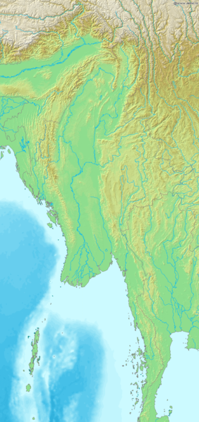
ملف:Map of Myanmar Demis.png
اذهب إلى التنقل
اذهب إلى البحث

حجم هذه المعاينة: 282 × 598 بكسل. الأبعاد الأخرى: 113 × 240 بكسل | 226 × 480 بكسل | 687 × 1٬457 بكسل.
الملف الأصلي (687 × 1٬457 بكسل حجم الملف: 498 كيلوبايت، نوع MIME: image/png)
| هذا ملف من ويكيميديا كومنز. معلومات من صفحة وصفه مبينة في الأسفل. كومنز مستودع ملفات ميديا ذو رخصة حرة. |
Map of Myanmar
Bounding box West 91°, South 9°, East 101.5°, North 30°. Center at 19°30′00″N 96°15′00″E / 19.50000°N 96.25000°E.
This image is in the public domain because it came from the site https://www.demis.nl/products/web-map-server/examples/ and was released by the copyright holder. Permission is granted to copy, distribute and/or modify this map since it is based on free of copyright images from: www.demis.nl. See also approval email on de.wp and its clarification.
|
| This work has been released into the public domain by its copyright holder, www.demis.nl. This applies worldwide. في بعض البلدان، قد يكون هذا التَّرخيص غيرَ مُمكنٍ قانونيَّاً، في هذه الحالة: يمنح www.demis.nl الجميع حق استخدام هذا العمل لأي غرض دون أي شرط ما لم يفرض القانون شروطًا إضافية.
|
تاريخ الملف
اضغط على زمن/تاريخ لرؤية الملف كما بدا في هذا الزمن.
| زمن/تاريخ | صورة مصغرة | الأبعاد | مستخدم | تعليق | |
|---|---|---|---|---|---|
| حالي | 22:36، 20 ديسمبر 2006 | | 687 × 1٬457 (498 كيلوبايت) | commonswiki>Mats Halldin~commonswiki | Map of Myanmar Bounding box West 91°, South 9°, East 101.5°, North 30°. Center at {{coor d|19.50000|N|96.25000|E|scale:12600000}}. {{demis-pd}} category:maps of Myanmar |
استخدام الملف
ال1 ملف التالي مكررات لهذا الملف (المزيد من التفاصيل):
- ملف:Map of Myanmar Demis.png من ويكيميديا كومنز
الصفحة التالية تستخدم هذا الملف: