ملف:Map of Jupiter.jpg

من أرابيكا، الموسوعة الحرة
اذهب إلى التنقل اذهب إلى البحث

الملف الأصلي(2٬231 × 2٬266 بكسل حجم الملف: 426 كيلوبايت، نوع MIME: image/jpeg)

ويكيبيديا

 هذه الصُّورة مُختارةٌ على ويكيبيديا الإنجليزية (Featured pictures) و مُرشَّحة لتَكُون إحدى أَفضل الصُّور.

إِذا كُنت تَعتَقِد بأَنَّ هذه الصُّورة يجب أَن تَكُون صُورةً مُختارةً على وِيكيميديا كُومِنز، رشِّحها!.
إذا كان لديك صُورةٌ ذاتُ جُودةٍ مُماثِلةٍ، فمِن المُمكِن نَشرُها تحت رُخصة مُناسِبة، ارفعها، وأَضف وسوم حقوق التَّأليف والنَّشر إِليها، ثُمَّ رشِّحها.

ملخص

الوصف
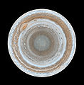
English: :This map of Jupiter is the most detailed global color map of the planet ever produced. The round map is a polar stereographic projection that shows the south pole in the center of the map and the equator at the edge. It was constructed from images taken by Cassini on Dec. 11 and 12, 2000, as the spacecraft neared Jupiter during a flyby on its way to Saturn. The map shows a variety of colorful cloud features, including parallel reddish-brown and white bands, the Great Red Spot, multi-lobed chaotic regions, white ovals and many small vortices. Many clouds appear in streaks and waves due to continual stretching and folding by Jupiter's winds and turbulence. The bluish-gray features along the north edge of the central bright band are equatorial "hot spots," meteorological systems such as the one entered by NASA's Galileo probe. Small bright spots within the orange band north of the equator are lightning-bearing thunderstorms. The polar region shown here is less clearly visible because Cassini viewed it at an angle and through thicker atmospheric haze.
التاريخ 11-12 December 2000
المصدر From http://www.nasa.gov/multimedia/imagegallery/image_feature_539.html
المؤلف NASA/JPL/Space Science Institute
الترخيص
(إعادة استخدام هذا الملف)
PD-USGOV-NASA.
إصدارات أخرى

ترخيص

Public domain يقع هذا العمل في النِّطاق العامّ في الولايات المُتحدة الأمريكيَّة لأَنَّه عملٌ خالِصٌ من إِنتاج وكالة الفضاء الأمريكيَّة. تنصُ حقوق التَّأليف والنَّشر الخاصَّة بوكالة الفضاء الأمريكيَّة على أنَّ "أعمال الوكالة غير مَحميَّة بحقوق التَّأليف والنَّشر ما لم يُذكر خلافُ ذلك". لمزيدٍ من المعلومات انظر القالِب {{PD-USGov}} وصفحة حقوق التَّأليف والنَّشر الخاصَّة بالوكالة وصفحة سياسة الصُّور الخاصَّة بمُختبر الدَّفع النَّفَّاث.
تنبيهات:

تاريخ الملف

اضغط على زمن/تاريخ لرؤية الملف كما بدا في هذا الزمن.

زمن/تاريخصورة مصغرةالأبعادمستخدمتعليق
حالي14:59، 14 فبراير 2007تصغير للنسخة بتاريخ 14:59، 14 فبراير 20072٬231 × 2٬266 (426 كيلوبايت)commonswiki>Helix84{{en| :This map of Jupiter is the most detailed global color map of the planet ever produced. The round map is a polar stereographic projection that shows the south pole in the center of the map and the equator at the edge. It was constructed from images

ال1 ملف التالي مكررات لهذا الملف (المزيد من التفاصيل):

الصفحة التالية تستخدم هذا الملف:

بيانات وصفية