|
تضامنًا مع حق الشعب الفلسطيني |
ملف:Maas Delta1.jpg
اذهب إلى التنقل
اذهب إلى البحث
حجم هذه المعاينة: 387 × 600 بكسل. البعدان الآخران: 155 × 240 بكسل | 616 × 955 بكسل.
الملف الأصلي (616 × 955 بكسل حجم الملف: 221 كيلوبايت، نوع MIME: image/jpeg)
| هذا ملف من ويكيميديا كومنز. معلومات من صفحة وصفه مبينة في الأسفل. كومنز مستودع ملفات ميديا ذو رخصة حرة. |
ملخص
| الوصف |
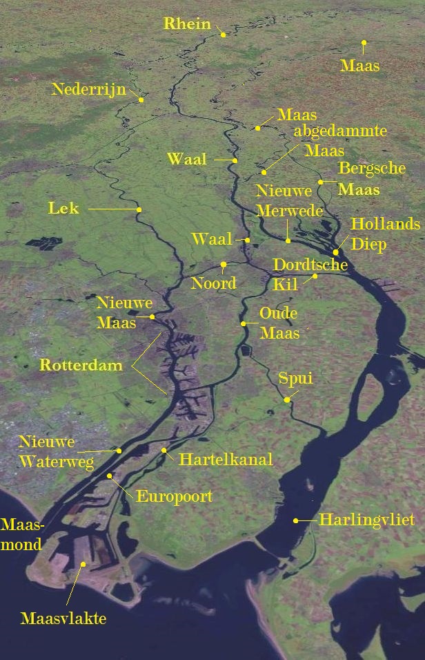
Deutsch: Rhein-Maas-Delta |
| التاريخ | |
| المصدر | This image is in the public domain because it is a screenshot from NASA World Wind screenshot. and is public domain. Dieser Screenshot wurde von mir um die Namen der wesentlichen Flüsse des Deltas ergänzt. Basiert auf Bildvorlage: File:Rivieren 4.46933E 51.88083N.jpg. |
| المؤلف | NASA World Wind, annotations by L.1951a |
ترخيص
| هذه الصُّورة في النِّطاق العامِّ لأنها لقطة شاشةٍ مِن تطبيق وُرد ويند الخاصِّ بوكالة الفضاء الأمريكيَّة مأخوذةٌ مِن نمطٍ يَستعمل طَبقةً مَوجُودةً في النِّطاق العامِّ أساساً.
|
 |
das Image ist public domain und auch von mir freigeggeben.
سجلُّ الرَّفع الأصيل
نُقِلت من de.wikipedia إلى كُومُنز بواسطة Andrei Stroe باستخدام CommonsHelper.
صفحة الوصف الأصلية كانت هنا، تشير جميع أسماء المستخدمين التالية إلى de.wikipedia.
- 2008-11-02 08:00 L.1951a 1280×958× (197700 bytes) {{Information |Beschreibung = Rhein/Maas Delta |Quelle = Auf Basis :This image is in the public domain because it is a screenshot from NASA’s globe software World Wind using Blue Marble, Landsat or USGS layer, all of which are in public domain, ergänzt
- 2008-11-01 17:25 L.1951a 1280×958× (197896 bytes) {{Information |Beschreibung = Rhein/Maas Delta |Quelle = Auf Basis :This image is in the public domain because it is a screenshot from NASA’s globe software World Wind using Blue Marble, Landsat or USGS layer, all of which are in public domain ergänzt
تاريخ الملف
اضغط على زمن/تاريخ لرؤية الملف كما بدا في هذا الزمن.
| زمن/تاريخ | صورة مصغرة | الأبعاد | مستخدم | تعليق | |
|---|---|---|---|---|---|
| حالي | 17:06، 2 أكتوبر 2021 | | 616 × 955 (221 كيلوبايت) | commonswiki>Erledigt | zusätzliche Beschriftungen |
استخدام الملف
ال1 ملف التالي مكررات لهذا الملف (المزيد من التفاصيل):
- ملف:Maas Delta1.jpg من ويكيميديا كومنز
الصفحة التالية تستخدم هذا الملف: