|
تضامنًا مع حق الشعب الفلسطيني |
ملف:Koninkrijk der Nederlanden.png
اذهب إلى التنقل
اذهب إلى البحث

حجم هذه المعاينة: 624 × 599 بكسل. الأبعاد الأخرى: 250 × 240 بكسل | 500 × 480 بكسل | 799 × 768 بكسل | 1٬171 × 1٬125 بكسل.
الملف الأصلي (1٬171 × 1٬125 بكسل حجم الملف: 241 كيلوبايت، نوع MIME: image/png)
| هذا ملف من ويكيميديا كومنز. معلومات من صفحة وصفه مبينة في الأسفل. كومنز مستودع ملفات ميديا ذو رخصة حرة. |
ملخص
| الوصف |
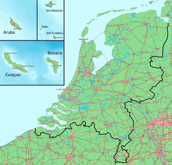
Deutsch: Karte des Königreichs der Niederlande. Das Festland und die Inseln befinden sich auf derselben Ebene.
English: Map of the Kingdom of the Netherlands. The mainland and all the islands are on the same scale.
Nederlands: Kaart van het Koninkrijk der Nederlanden. Het vasteland (Nederland) en de eilanden worden getoond op dezelfde schaal. |
||||
| التاريخ | |||||
| المصدر | Gebaseerd op/Based on http://www.demis.nl/wms/mapclip.htm (free software based on a free database/vrije software gebaseerd op een vrije database) | ||||
| المؤلف | Bewerkt door/Edited by Maarten van der Bent | ||||
| الترخيص (إعادة استخدام هذا الملف) |
|
تاريخ الملف
اضغط على زمن/تاريخ لرؤية الملف كما بدا في هذا الزمن.
| زمن/تاريخ | صورة مصغرة | الأبعاد | مستخدم | تعليق | |
|---|---|---|---|---|---|
| حالي | 03:13، 6 أغسطس 2010 | | 1٬171 × 1٬125 (241 كيلوبايت) | commonswiki>Ras67 | cropped and squeezed |
استخدام الملف
ال1 ملف التالي مكررات لهذا الملف (المزيد من التفاصيل):
- ملف:Koninkrijk der Nederlanden.png من ويكيميديا كومنز
الصفحتان التاليتان تستخدمان هذا الملف: