|
تضامنًا مع حق الشعب الفلسطيني |
ملف:Indian states affected by July 2012 power cuts.svg
اذهب إلى التنقل
اذهب إلى البحث

حجم معاينة PNG لذلك الملف ذي الامتداد SVG: 530 × 599 بكسل. الأبعاد الأخرى: 212 × 240 بكسل | 425 × 480 بكسل | 680 × 768 بكسل | 906 × 1٬024 بكسل | 1٬812 × 2٬048 بكسل | 1٬639 × 1٬852 بكسل.
الملف الأصلي (ملف SVG، أبعاده 1٬639 × 1٬852 بكسل، حجم الملف: 314 كيلوبايت)
| هذا ملف من ويكيميديا كومنز. معلومات من صفحة وصفه مبينة في الأسفل. كومنز مستودع ملفات ميديا ذو رخصة حرة. |
ملخص
| الوصف |
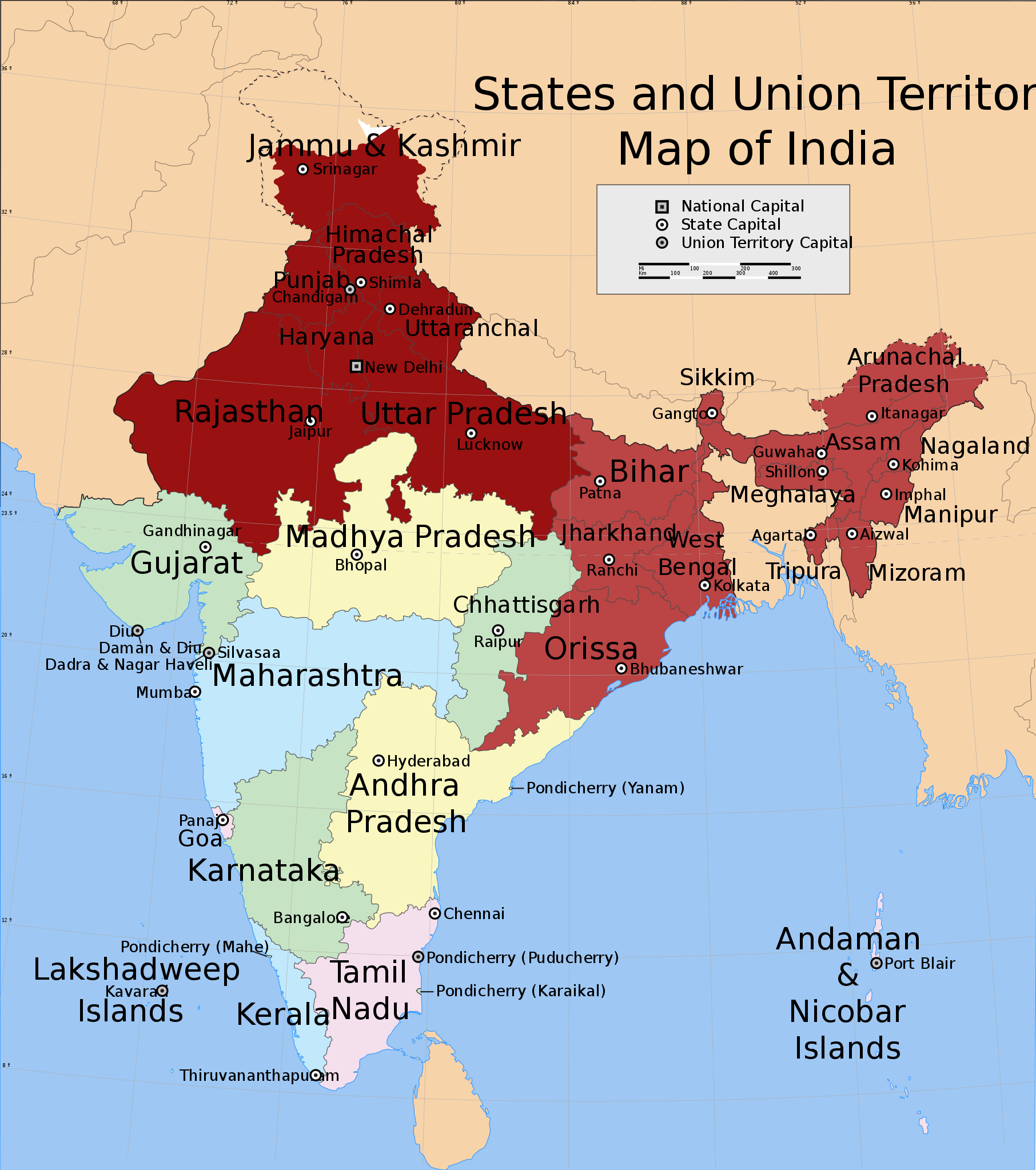
English: Shows in dark red the states listed at the time of creation: Jammu and Kashmir, Himachal Pradesh, Punjab, Haryana, Delhi, Rajasthan, Uttar Pradesh, Bihar, West Bengal, Orissa, Jharkhand, Sikkim, Assam, Meghalaya, Tripura, Nagaland, Manipur, Mizoram and Arunachal Pradesh.
Derived from India_states_and_union_territories_map.svg by changing the fill colour for those states. |
| التاريخ | Not known. Modified ٣١ يوليو ٢٠١٢ |
| المصدر | File:India_states_and_union_territories_map.svg |
| المؤلف | Whoever uploaded File:India_states_and_union_territories_map.svg to English Wikipedia |
| الترخيص (إعادة استخدام هذا الملف) |
http://en.wikipedia.org |
ترخيص
هذا الملف مُرخص تحت رخصة المشاع الإبداعي نسبة المصنف إلى مؤلفه - المشاركة على قدم المساواة 1.0 العامة.
- يحقُّ لك:
- مشاركة العمل – نسخ العمل وتوزيعه وبثُّه
- إعادة إنتاج العمل – تعديل العمل
- حسب الشروط التالية:
- نسب العمل إلى مُؤَلِّفه – يلزم نسب العمل إلى مُؤَلِّفه بشكل مناسب وتوفير رابط للرخصة وتحديد ما إذا أجريت تغييرات. بالإمكان القيام بذلك بأية طريقة معقولة، ولكن ليس بأية طريقة تشير إلى أن المرخِّص يوافقك على الاستعمال.
- الإلزام بترخيص المُشتقات بالمثل – If you alter, transform, or build upon this work, you must distribute the resulting work under the same license as the original.
سجلُّ الرَّفع الأصيل
نُقِلت من en.wikipedia إلى كُومُنز .
صفحة الوصف الأصلية كانت هنا، تشير جميع أسماء المستخدمين التالية إلى en.wikipedia.
- 2012-07-31 20:55 Maproom 1639×1852× (309753 bytes) Added Uttaranchal to affected area, removed Assam and states south and east of it.
- 2012-07-31 17:29 Maproom 1639×1852× (309753 bytes) Uploading a file from a free published source using [[Wikipedia:File_Upload_Wizard|File Upload Wizard]]
صفحة الوصف الأصلية كانت هنا، تشير جميع أسماء المستخدمين التالية إلى en.wikipedia.
- 2012-08-01 15:07 Maproom 1639×1852× (309753 bytes) altered the status of (Bihar, West Bengal, Jharkhand, Orissa, Chhattisgarh) to 2nd-day only.
- 2012-08-01 08:12 Maproom 1639×1852× (309753 bytes) re-added the north-eastern states, in a lighter colour
- 2012-08-01 08:09 Maproom 1639×1852× (309753 bytes) re-added the north-eastern states, in a lighter colour
- 2012-07-31 20:55 Maproom 1639×1852× (309753 bytes) Added Uttaranchal to affected area, removed Assam and states south and east of it.
- 2012-07-31 17:29 Maproom 1639×1852× (309753 bytes) Uploading a file from a free published source using [[Wikipedia:File_Upload_Wizard|File Upload Wizard]]
تاريخ الملف
اضغط على زمن/تاريخ لرؤية الملف كما بدا في هذا الزمن.
| زمن/تاريخ | صورة مصغرة | الأبعاد | مستخدم | تعليق | |
|---|---|---|---|---|---|
| حالي | 20:11، 2 سبتمبر 2024 | | 1٬639 × 1٬852 (314 كيلوبايت) | commonswiki>Belbury | update caption |
استخدام الملف
ال1 ملف التالي مكررات لهذا الملف (المزيد من التفاصيل):
- ملف:Indian states affected by July 2012 power cuts.svg من ويكيميديا كومنز
الصفحة التالية تستخدم هذا الملف: