|
تضامنًا مع حق الشعب الفلسطيني |
ملف:Himalayan Tectonic Summary.png
اذهب إلى التنقل
اذهب إلى البحث
حجم هذه المعاينة: 800 × 519 بكسل. الأبعاد الأخرى: 320 × 207 بكسل | 640 × 415 بكسل | 1٬024 × 664 بكسل | 1٬280 × 830 بكسل | 2٬658 × 1٬723 بكسل.
الملف الأصلي (2٬658 × 1٬723 بكسل حجم الملف: 729 كيلوبايت، نوع MIME: image/png)
| هذا ملف من ويكيميديا كومنز. معلومات من صفحة وصفه مبينة في الأسفل. كومنز مستودع ملفات ميديا ذو رخصة حرة. |
ملخص
| الوصف |
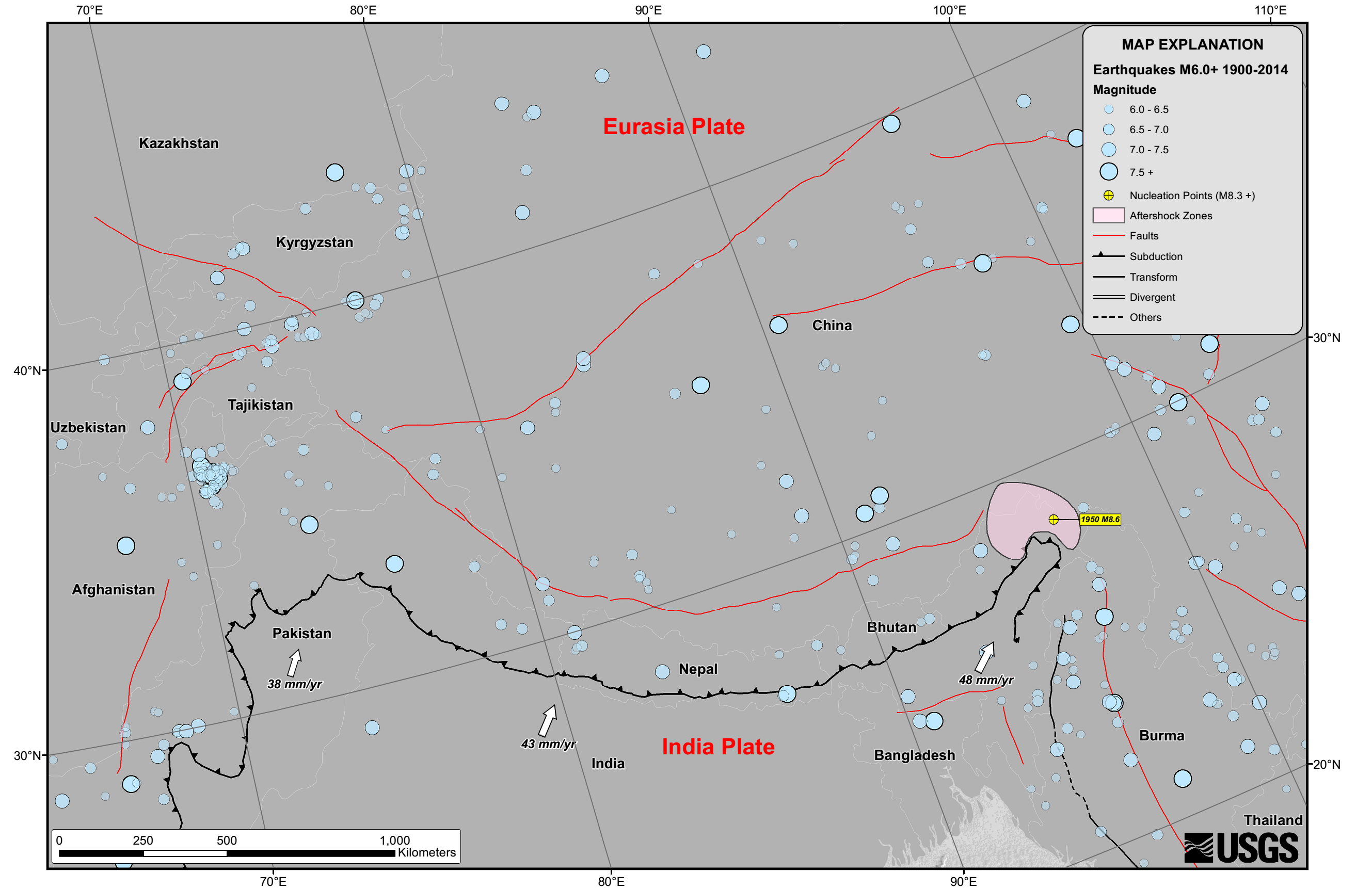
English: Seismicity in the Himalaya dominantly results from the continental collision of the India and Eurasia plates, which are converging at a relative rate of 40-50 mm/yr. Northward underthrusting of India beneath Eurasia generates numerous earthquakes and consequently makes this area one of the most seismically hazardous regions on Earth. The surface expression of the plate boundary is marked by the foothills of the north-south trending Sulaiman Range in the west, the Indo-Burmese Arc in the east and the east-west trending Himalaya Front in the north of India. |
| التاريخ | |
| المصدر | https://earthquake.usgs.gov/earthquakes/tectonic/images/himalaya_tsum.pdf |
| المؤلف | United States Geological Survey |
ترخيص
تقع هذه الصُّورة في النِّطاق العامّ لأنَّها تحتوي مواد حصريَّة مِن إِنتاج هيئة المساحة الجيولوجيَّة الأمريكيَّة في وزارة الداخلية في الولايات المُتحدة الأمريكيَّة. للمزيد مِن المعلومات انظر سياسية حقوق التَّأليف والنَّشر في موقع هيئة المساحة الجيولوجيَّة الأمريكيَّة الرسميَّة.
|
تاريخ الملف
اضغط على زمن/تاريخ لرؤية الملف كما بدا في هذا الزمن.
| زمن/تاريخ | صورة مصغرة | الأبعاد | مستخدم | تعليق | |
|---|---|---|---|---|---|
| حالي | 14:53، 26 أبريل 2015 | | 2٬658 × 1٬723 (729 كيلوبايت) | commonswiki>Tatiraju.rishabh | User created page with UploadWizard |
استخدام الملف
ال1 ملف التالي مكررات لهذا الملف (المزيد من التفاصيل):
- ملف:Himalayan Tectonic Summary.png من ويكيميديا كومنز
الصفحة التالية تستخدم هذا الملف: