ملف:France départementale.svg

من أرابيكا، الموسوعة الحرة
اذهب إلى التنقل اذهب إلى البحث

الملف الأصلي(ملف SVG، أبعاده 2٬000 × 1٬898 بكسل، حجم الملف: 1٫87 ميجابايت)

ملخص

الوصف
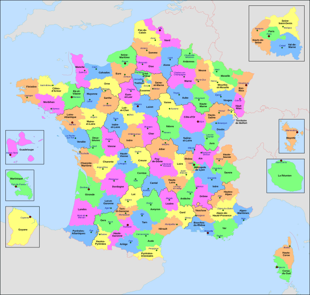
Français : Carte administrative de la France, créée sous Inkscape 0.47 à partir de plusieurs cartes (notamment celle-ci) créées par Sting.

Le fichier comporte vingt-quatre calques : Cadre, Chef-lieux de région, Villes, Chef-lieux de département, Numéros de département, Noms des régions, Nom des départements, **Encarts Départements d'Outre-Mer, **Encart Paris-Petite-Couronne, Coordonnées, Échelle et Mini-carte, Frontières internationales, Côtes, Limites régionales, Limites départementales, Lacs, Fleuves, *Régions métropolitaines, *Départements métropolitains, Terres françaises, Terres étrangères, Mers et océans, Échelle altimétrique, Topographie.

  • Calque visible Calque caché
  • L'astérisque signale un calque comportant des sous-calques
  • La double astérisque signale un calque comportant des sous-calques dont certains comportent eux-mêmes des sous-calques
English: Administrative map of France, created under Inkscape 0.47 from several of the maps (especially this one) created by Sting.

The file consists of twenty-four layers: Frame, Administrative Centres of Regions, Towns, Administrative Centres of Departments, Numbers of Departments, Names of Regions, Names of Departments, **Overseas Departements Insets, **Paris Conurbation Inset, Coordinates, Scale and Mini-map, International boundaries, Coasts, Regional boundaries, Departmental boundaries, Lakes, Rivers, *Metropolitan Regions, *Metropolitan Departments, French lands, Foreign lands, Seas and Oceans, Altimetric Scale, Topography.

  • Visible Layer Hidden Layer
  • The asterisk indicates a layer with sublayers
  • The double asterisk indicates a layer with sublayers, some of which have sublayers
التاريخ
المصدر عمل شخصي
المؤلف Nilstilar
إصدارات أخرى
SVG منشأ الملف
InfoField
 
الشيفرة المصدرية لهذا الرسم المتجه صالحة.
 
.هذا الرسم المتجهي أُنشئ بواسطة Inkscape
 
 This map uses embedded text that can be easily translated using a text editor.

ترخيص

أنا، صاحب حقوق التأليف والنشر لهذا العمل، أنشر هذا العمل تحت الرخصة التالية:
w:ar:مشاع إبداعي
نسب العمل إلى مُؤَلِّفه الإلزام بترخيص المُشتقات بالمثل
يحقُّ لك:
  • مشاركة العمل – نسخ العمل وتوزيعه وبثُّه
  • إعادة إنتاج العمل – تعديل العمل
حسب الشروط التالية:
  • نسب العمل إلى مُؤَلِّفه – يلزم نسب العمل إلى مُؤَلِّفه بشكل مناسب وتوفير رابط للرخصة وتحديد ما إذا أجريت تغييرات. بالإمكان القيام بذلك بأية طريقة معقولة، ولكن ليس بأية طريقة تشير إلى أن المرخِّص يوافقك على الاستعمال.
  • الإلزام بترخيص المُشتقات بالمثل – إذا أعدت إنتاج المواد أو غيرت فيها، فيلزم أن تنشر مساهماتك المُشتقَّة عن الأصل تحت ترخيص الأصل نفسه أو تحت ترخيص مُتوافِقٍ معه.

This image is used on a user page of a Wikimedia user and is stored on Commons according to the rules set out in Commons:Project scope#File in use on Commons only: the uploading of small numbers of images (e.g. of yourself) for use on a personal Commons user page is allowed or Commons:Project scope#File in use in another Wikimedia project: the uploading of small numbers of images (e.g. of yourself) for use on a personal user page of another project is allowed as long as that user is or was an active participant on that project.
If the image ceases to be used it may be eligible for deletion as it may have no educational purpose.


الشروحات

أضف شرحاً من سطر واحد لما يُمثِّله هذا الملف
Kartenn departamantoù Bro-C'hall

العناصر المصورة في هذا الملف

يُصوِّر

٢٥ يوليو 2010

تاريخ الملف

اضغط على زمن/تاريخ لرؤية الملف كما بدا في هذا الزمن.

زمن/تاريخصورة مصغرةالأبعادمستخدمتعليق
حالي00:29، 23 يونيو 2022تصغير للنسخة بتاريخ 00:29، 23 يونيو 20222٬000 × 1٬898 (1٫87 ميجابايت)commonswiki>OpesMentisAdded hyphens on departments' names and towns' names and fixed "Réunion" to "La Réunion"

ال1 ملف التالي مكررات لهذا الملف (المزيد من التفاصيل):

الصفحة التالية تستخدم هذا الملف:

بيانات وصفية