|
تضامنًا مع حق الشعب الفلسطيني |
ملف:Extent of the Hansa.png
اذهب إلى التنقل
اذهب إلى البحث

حجم هذه المعاينة: 800 × 445 بكسل. الأبعاد الأخرى: 320 × 178 بكسل | 640 × 356 بكسل | 1٬250 × 695 بكسل.
الملف الأصلي (1٬250 × 695 بكسل حجم الملف: 141 كيلوبايت، نوع MIME: image/png)
| هذا ملف من ويكيميديا كومنز. معلومات من صفحة وصفه مبينة في الأسفل. كومنز مستودع ملفات ميديا ذو رخصة حرة. |
| الوصف |
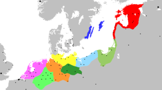
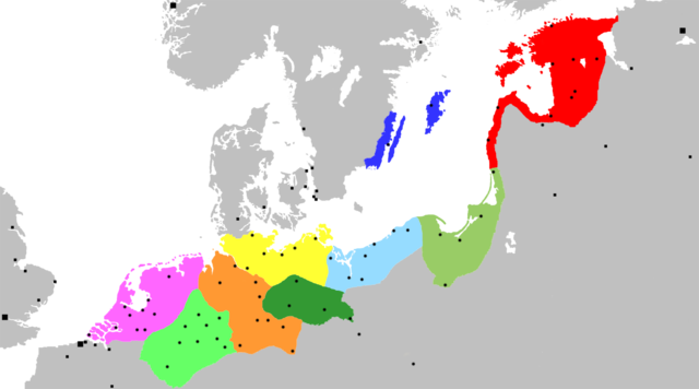
Map of the Hanseatic League, circa 1400, showing Circles, Kontore and principal Hanseatic cities Netherlands Circle
Westphalian Circle
Saxon Circle
Wendish Circle
Margravian Circle
Pomeranian Circle
Prussian Circle
Livonian Circle
Swedish Circle
Squares indicate Kontore; dots indicate Hanseatic cities. |
||
| التاريخ | (UTC) | ||
| المصدر | Adapted from Image:Extent of the Hansa.jpg, itself in the public domain because its first publication occurred in 1902 — prior to January 1, 1923 | ||
| المؤلف | OwenBlacker | ||
| الترخيص (إعادة استخدام هذا الملف) |
|
||
| إصدارات أخرى | Image:Extent of the Hansa.jpg |
تاريخ الملف
اضغط على زمن/تاريخ لرؤية الملف كما بدا في هذا الزمن.
| زمن/تاريخ | صورة مصغرة | الأبعاد | مستخدم | تعليق | |
|---|---|---|---|---|---|
| حالي | 04:12، 20 نوفمبر 2007 | | 1٬250 × 695 (141 كيلوبايت) | commonswiki>OwenBlacker | {{Information |Description= Map of the Hanseatic League, circa 1400, showing Circles, ''Kontore'' and principal Hanseatic cities |Source= Adapted from Image:Extent of the Hansa.jpg |Date=~~~~~ |Author=~~~ |Permission={{PD-self}} |other_versio |
استخدام الملف
ال1 ملف التالي مكررات لهذا الملف (المزيد من التفاصيل):
- ملف:Extent of the Hansa.png من ويكيميديا كومنز
ال67 صفحة التالية تستخدم هذا الملف:
- أنتويرب
- أوسنابروك
- أولدنزال
- إبسوتش
- إرفورت
- إلبلنغ
- الرابطة الهانزية
- براونشفايغ (مدينة)
- برغن
- برلين
- بروج
- بريمن
- بسكوف
- بوخوم
- بوسطن (إنجلترا)
- بولوتسك
- بيتيرهوف
- تارتو
- تالين
- تورون
- تيل (هولندا)
- خرننغن
- دامه
- دورتموند
- دويسبورغ
- ديفينتر
- رورموند
- روستوك
- ريغا
- زفوله
- زوتفن
- زوست
- ستارغارد
- ستوكهولم
- شتاده
- شترالزوند
- غدانسك
- غرايفسفالد
- غوسلار
- فروتسواف
- فيسبي
- فيليكي نوفغورود
- كالينينغراد
- كامبن (هولندا)
- كاوناس
- كراكوف
- كولونيا
- كونيغسبرغ
- كيل
- كينغستون أبون هال
- لندن
- لوبيك
- لونبورغ
- ماغديبورغ
- مجلس شيوخ مدينة هامبورغ (حكومة هامبورغ)
- مولهاوزن (تورينغيا)
- مونستر
- نايميخن
- نوردهاوزن
- نيوكاسل أبون تاين
- هاتيم
- هاردرفايك
- هاله (سكسونيا-أنهالت)
- هام (مدينة)
- هامبورغ
- يورك
- قالب:الرابطة الهانزية