|
تضامنًا مع حق الشعب الفلسطيني |
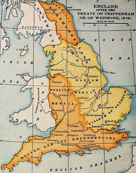
ملف:England-878ad.jpg

الملف الأصلي (735 × 935 بكسل حجم الملف: 127 كيلوبايت، نوع MIME: image/jpeg)
| هذا ملف من ويكيميديا كومنز. معلومات من صفحة وصفه مبينة في الأسفل. كومنز مستودع ملفات ميديا ذو رخصة حرة. |

|
This map has been uploaded by Electionworld from en.wikipedia.org to enable the |
England and Wales at the time of the Treaty of Chippenham (AD 878). From the Atlas of European History, Earle W Dowe (d. 1946), G Bell and Sons, London, 1910
[]
-
 Cymraeg
 -
 Deutsch
 -
 English
 -
 English
 -
 English
 -
 español
 -
 français
 -
 Nederlands
 -
 polski
 -
 magyar


.svg)


|
تُوفِّي المُؤَلِّف في عام 1946، ولذلك فإِنَّ هذا العمل يقع في النَّطاق العامّ في بلد المنشأ وفي البلدان الأخرى والمناطق التي تمتدُّ فيها مدة حقوق التَّأليف والنشر لتغطي زمن حياة المُؤلِّف و 75 سنةً بعد وفاته أو أقل من ذلك. يقع هذ العمل في النَّطاق العامِّ في الولايات المُتحدة الأمريكيَّة لأنَّه نُشِرَ (أو سُجِّل لدى مكتب الولايات المُتحدة لحقوق التَّأليف والنَّشر) قبل ١ يناير ١٩٢٩. | |
| هذا الملفُّ مَلحُوظُ بصفته غيرَ مُقيَّدٍ بحقوق التَّأليف والنشر، وهذا يشمل أيضاً الحقوق المُجاوِرة أَو ذات الصلة جميعُها. | |
تاريخ الملف
اضغط على زمن/تاريخ لرؤية الملف كما بدا في هذا الزمن.
| زمن/تاريخ | صورة مصغرة | الأبعاد | مستخدم | تعليق | |
|---|---|---|---|---|---|
| حالي | 23:27، 7 نوفمبر 2011 | | 735 × 935 (127 كيلوبايت) | commonswiki>Hel-hama | same source, better version of the image |
استخدام الملف
ال1 ملف التالي مكررات لهذا الملف (المزيد من التفاصيل):
- ملف:England-878ad.jpg من ويكيميديا كومنز
الصفحة التالية تستخدم هذا الملف: