ملف:End.of.Roman.rule.in.Britain.383.410.jpg

الملف الأصلي (2٬582 × 3٬220 بكسل حجم الملف: 1٬010 كيلوبايت، نوع MIME: image/jpeg)
| هذا ملف من ويكيميديا كومنز. معلومات من صفحة وصفه مبينة في الأسفل. كومنز مستودع ملفات ميديا ذو رخصة حرة. |
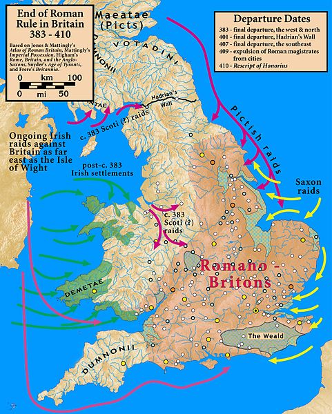
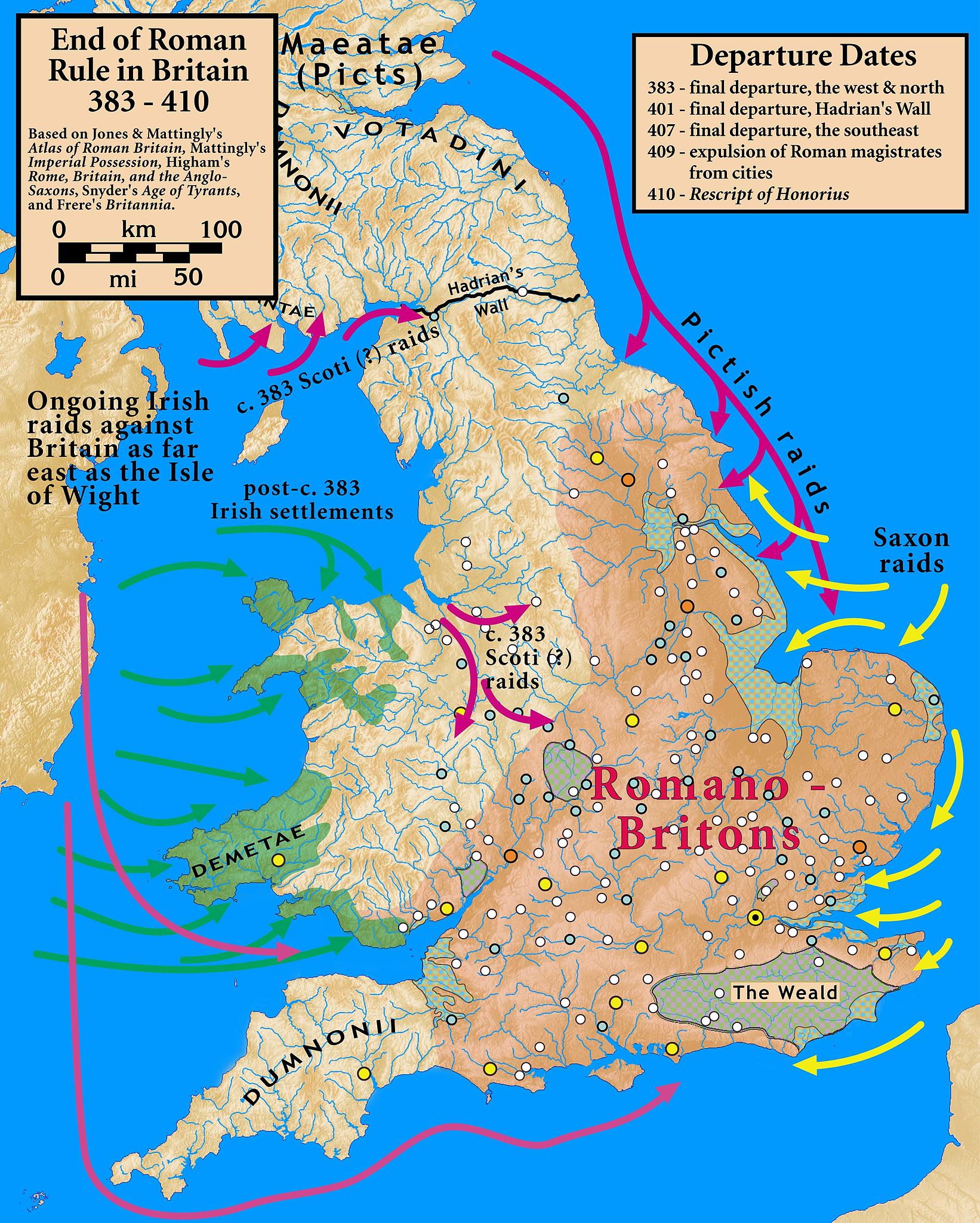
| الوصف | End of Roman Rule in Britain, 383–410 |
| التاريخ | |
| المصدر |
Based on Jones & Mattingly's Atlas of Roman Britain (ISBN 978-1-84217-06700, 1990, reprinted 2007); Mattingly's Imperial Possession ( ISBN 978-0-140-14822-0, 2006); Higham's Rome, Britain, and the Anglo-Saxons (ISBN 1-85264-022-7, 1992); Frere's Britannia (ISBN 0-7102-1215-1, 1987); and Snyder's An Age of Tyrants (ISBN 978-0-631-22260-6) — the sources are cited in the image legend — Locations of towns (fortified and unfortified) are given on p. 156, with tribal civitates and coloniae specified on p. 154, of Atlas of Roman Britain. Specification of the Romanized regions of Britain are also from the Atlas, p. 151. The "Departure Dates" are found in the cited sources, and are generally known. The Pictish, Saxon, and Scoti raids are found in the cited sources, as is the date of the Irish settlements in Wales. Frere suggests (p. 355) that it was the Irish who sacked Wroxeter c. 383. The locations of the Irish settlements is from the locations of inscription stones given in File:Britain.Deisi.Laigin.jpg as of 2010-10-11, which cites its sources of information.
|
| المؤلف | my work |
- يحقُّ لك:
- مشاركة العمل – نسخ العمل وتوزيعه وبثُّه
- إعادة إنتاج العمل – تعديل العمل
- حسب الشروط التالية:
- نسب العمل إلى مُؤَلِّفه – يلزم نسب العمل إلى مُؤَلِّفه بشكل مناسب وتوفير رابط للرخصة وتحديد ما إذا أجريت تغييرات. بالإمكان القيام بذلك بأية طريقة معقولة، ولكن ليس بأية طريقة تشير إلى أن المرخِّص يوافقك على الاستعمال.
- الإلزام بترخيص المُشتقات بالمثل – إذا أعدت إنتاج المواد أو غيرت فيها، فيلزم أن تنشر مساهماتك المُشتقَّة عن الأصل تحت ترخيص الأصل نفسه أو تحت ترخيص مُتوافِقٍ معه.

|
هذه historical map الصورة / الصورتان باستعمال رسومات متجهية ملفات رسوميات شعاعية.
It is recommended to name the SVG file "End.of.Roman.rule.in.Britain.383.410.svg" - then the template Vector version available (or Vva) does not need the new image name parameter.
|


تاريخ الملف
اضغط على زمن/تاريخ لرؤية الملف كما بدا في هذا الزمن.
| زمن/تاريخ | صورة مصغرة | الأبعاد | مستخدم | تعليق | |
|---|---|---|---|---|---|
| حالي | 00:07، 19 أكتوبر 2010 | | 2٬582 × 3٬220 (1٬010 كيلوبايت) | commonswiki>Notuncurious | {{Information |Description=End of Roman Rule in Britain, 383–410 |Source=Based on Jones & Mattingly's ''Atlas of Roman Britain'' (ISBN 978-1-84217-06700, 1990, reprinted 2007); Mattingly's ''Imperial Possession'' ( ISBN 978-0-140-14822-0, 2006); Hig |
استخدام الملف
ال1 ملف التالي مكررات لهذا الملف (المزيد من التفاصيل):
- ملف:End.of.Roman.rule.in.Britain.383.410.jpg من ويكيميديا كومنز
الصفحة التالية تستخدم هذا الملف: