|
تضامنًا مع حق الشعب الفلسطيني |
ملف:EFS highres STS066 STS066-101-39.JPG
اذهب إلى التنقل
اذهب إلى البحث

حجم هذه المعاينة: 600 × 600 بكسل. الأبعاد الأخرى: 240 × 240 بكسل | 480 × 480 بكسل | 768 × 768 بكسل | 1٬024 × 1٬024 بكسل | 2٬048 × 2٬048 بكسل | 4٬030 × 4٬030 بكسل.
الملف الأصلي (4٬030 × 4٬030 بكسل حجم الملف: 14٫71 ميجابايت، نوع MIME: image/jpeg)
| هذا ملف من ويكيميديا كومنز. معلومات من صفحة وصفه مبينة في الأسفل. كومنز مستودع ملفات ميديا ذو رخصة حرة. |
ملخص
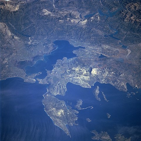
Photograph of the Ambracian Gulf, taken by space-shuttle mission STS-66 in November 1994.
Original caption, from [1] نسخة مؤرشفة at the Wayback Machine:
- STS066-101-039 Levkas Island, Ambracian Bay, Greece November, 1994
- The Ambracian Bay, an inlet of the Ionian Sea (bottom left) can be seen in this northeast-looking view. The bay, sometimes referred to as a gulf, is 25 miles 40 km) long and from 4 to 10 miles (6 to 16 km) wide. On the shores of Ambracian Bay are the ruins of several cities important to ancient Greece. Levkas (Leucas) Island is visible in the lower left quadrant of the image. Levkas Island is a mountainous island that covers an area of 115 square miles (300 square km). Olive oil, wine, and tobacco are produced on the island. Covering almost a third of the top portion of the image is the western half of the Pindus Mountains. The Pindus, trending northwest to southeast are a continuation of the Dinaric Alps, but are made up of reduced limestone content compared to the range further to the north. Extending for 100 miles (160 km), the sparsely populated, rugged range is rich in timber. Lake Takhniti, a recreational lake, is discernible in the upper right portion of the image. Ithaki Island is visible near the bottom right of the image.
فُهرِست هذه الصُّورة أَو هذا التَّسجيل المرئي لدى وهو أحد المراكز التَّابعة لوكالة الفضاء الأَمريكيَّة (ناسا) تحت المُعرِّف STS066-101-039. لا يُشير هذه الوَسم إلى حالة حقوق التَّأليف والنَّشر الخاصَّة بالعمل المُرفَق؛ لا يزال وَسم حقوق التَّأليف والنَّشر مَطلُوباً، راجع كومنز:ترخيص لمزيدٍ من المعلومات. لغات أخرى:
|
ترخيص
| يقع هذا العمل في النِّطاق العامّ في الولايات المُتحدة الأمريكيَّة لأَنَّه عملٌ خالِصٌ من إِنتاج وكالة الفضاء الأمريكيَّة. تنصُ حقوق التَّأليف والنَّشر الخاصَّة بوكالة الفضاء الأمريكيَّة على أنَّ "أعمال الوكالة غير مَحميَّة بحقوق التَّأليف والنَّشر ما لم يُذكر خلافُ ذلك". لمزيدٍ من المعلومات انظر القالِب {{PD-USGov}} وصفحة حقوق التَّأليف والنَّشر الخاصَّة بالوكالة وصفحة سياسة الصُّور الخاصَّة بمُختبر الدَّفع النَّفَّاث. | ||
 |
تنبيهات:
|
تاريخ الملف
اضغط على زمن/تاريخ لرؤية الملف كما بدا في هذا الزمن.
| زمن/تاريخ | صورة مصغرة | الأبعاد | مستخدم | تعليق | |
|---|---|---|---|---|---|
| حالي | 10:21، 28 أغسطس 2005 | | 4٬030 × 4٬030 (14٫71 ميجابايت) | commonswiki>Delirium | Photograph of the Ambracian Gulf, taken by space-shuttle mission STS-66 in November 1994. Original caption, from [http://earth.jsc.nasa.gov/sseop/efs/photoinfo.pl?PHOTO=STS066-101-39]: :STS066-101-039 Levkas Island, Ambracian Bay, Greece November, 1994 T |
استخدام الملف
ال1 ملف التالي مكررات لهذا الملف (المزيد من التفاصيل):
- ملف:EFS highres STS066 STS066-101-39.JPG من ويكيميديا كومنز
الصفحتان التاليتان تستخدمان هذا الملف: