ملف:Deposition erosion.jpg

من أرابيكا، الموسوعة الحرة
اذهب إلى التنقل اذهب إلى البحث

الملف الأصلي(900 × 989 بكسل حجم الملف: 113 كيلوبايت، نوع MIME: image/jpeg)

هذه الصورة / الصورتان باستعمال رسومات متجهية ملفات رسوميات شعاعية. It is recommended to name the SVG file "Deposition erosion.svg" - then the template Vector version available (or Vva) does not need the new image name parameter.

ملخص

الوصف
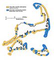
English: Map of Cape Cod showing those shores undergoing erosion (cliffed sections) in yellow, and shores characterized by marine deposition (barriers) in blue. Although the barriers are sites of marine deposition, in the long run, the ocean shore will retreat as the barrier keeps pace with the erosion of cliffed shorelines and as they adjust to sea-level rise.
التاريخ
المصدر U.S. Geological Survey
المؤلف Robert N. Oldale
موقع آلة التصوير٤١° ٤١′ ٠٦٫٥″ ش, ٧٠° ١٨′ ٠٠٫٥″ ب Kartographer map based on OpenStreetMap.هذه وغيرها من الصور في مواقعها على: خريطة الشارع المفتوحةinfo

ترخيص

Public domain

Bahasa Indonesia  català  čeština  Deutsch  eesti  English  español  français  galego  italiano  Nederlands  português  polski  sicilianu  suomi  Tiếng Việt  Türkçe  български  македонски  русский  മലയാളം  한국어  日本語  中文  中文(简体)  中文(繁體)  العربية  فارسی  +/−

الشروحات

أضف شرحاً من سطر واحد لما يُمثِّله هذا الملف

العناصر المصورة في هذا الملف

يُصوِّر

41°41'6.500"N, 70°18'0.500"W

تاريخ الملف

اضغط على زمن/تاريخ لرؤية الملف كما بدا في هذا الزمن.

زمن/تاريخصورة مصغرةالأبعادمستخدمتعليق
حالي02:40، 11 أكتوبر 2016تصغير للنسخة بتاريخ 02:40، 11 أكتوبر 2016900 × 989 (113 كيلوبايت)commonswiki>GrolltechAnisotrophic filter to smooth noise, larger image; shift colors for better accessibility to colorblind persons.

ال1 ملف التالي مكررات لهذا الملف (المزيد من التفاصيل):

الصفحة التالية تستخدم هذا الملف: