|
تضامنًا مع حق الشعب الفلسطيني |
ملف:Crete location map.png
Crete_location_map.png (326 × 498 بكسل حجم الملف: 28 كيلوبايت، نوع MIME: image/png)
| هذا ملف من ويكيميديا كومنز. معلومات من صفحة وصفه مبينة في الأسفل. كومنز مستودع ملفات ميديا ذو رخصة حرة. |
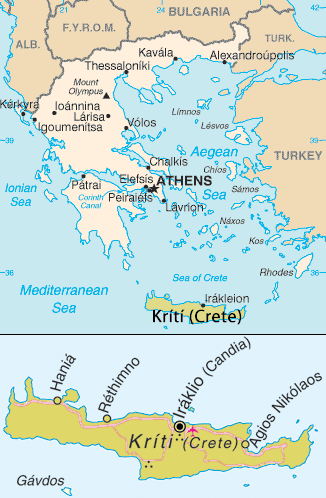
Map of Crete. Adapted from [1]
تقع هذه الصُّورة في النِّطاق العامِّ لأنها تتضمَّن مواد مأخوذةً من كتاب حقائق العالم الَّذي تصدره وكالة الاستخبارات المركزيَّة في الولايات المُتَّحدة الأمريكيَّة.
|
 |
| This image is a map derived from a United Nations map.
Unless stated otherwise, UN maps are to be considered in the public domain. This applies worldwide. UN maps are, in principle, open source material and you can use them in your work or for making your own map. UN requests however that you delete the UN name, logo and reference number upon any modification to the map. Content of your map will be your responsibility. You can state in your publication, if you wish, something like: based on UN map … (map name, map number, revision number and date). See: Geospatial Information Section. And: Geospatial, location data for a better world. |
 |
تاريخ الملف
اضغط على زمن/تاريخ لرؤية الملف كما بدا في هذا الزمن.
| زمن/تاريخ | صورة مصغرة | الأبعاد | مستخدم | تعليق | |
|---|---|---|---|---|---|
| حالي | 21:50، 31 أغسطس 2013 | | 326 × 498 (28 كيلوبايت) | commonswiki>Hedwig in Washington | Reverted to version as of 15:54, 26 July 2011 |
استخدام الملف
ال1 ملف التالي مكررات لهذا الملف (المزيد من التفاصيل):
- ملف:Crete location map.png من ويكيميديا كومنز
الصفحتان التاليتان تستخدمان هذا الملف: