|
تضامنًا مع حق الشعب الفلسطيني |
ملف:Claremont square, Islington (4) - geograph.org.uk - 1523975.jpg
Claremont_square,_Islington_(4)_-_geograph.org.uk_-_1523975.jpg (640 × 433 بكسل حجم الملف: 120 كيلوبايت، نوع MIME: image/jpeg)
| هذا ملف من ويكيميديا كومنز. معلومات من صفحة وصفه مبينة في الأسفل. كومنز مستودع ملفات ميديا ذو رخصة حرة. |
_-_geograph.org.uk_-_1523975.jpg)
ملخص
| الوصف |
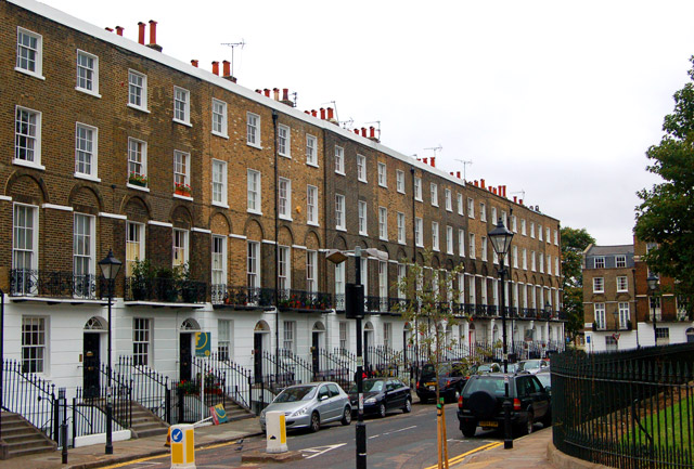
English: Claremont square, Islington (4) Looking southwest at the south side of Claremont Square, Islington. The square was developed in the 1820s around the Upper Pond of the New River Company.
The New River is a man-made water channel which carried drinking water for 20 miles to London from the River Lee and Amwell Springs in Hertfordshire. It opened in 1613 and fed reservoirs in Islington. One of these, known as the Upper Pond, was built in 1709 beside Pentonville Road. The reservoir in Claremont Square was covered and turfed in 1852 when open areas of standing water in London were prohibited by law. The reservoir is still in use by Thames Water. The semi-improved grassland on the top and sides of the reservoir supports a wide diversity of wild flowers and is a preserved habitat with restricted access. In this photo, the bank of the reservoir is just visible on the right of the picture. See also [1] and [2] . |
| التاريخ | |
| المصدر | From geograph.org.uk |
| المؤلف | Andy F |
| نسب العمل لمُؤَلِّفه (required by the license) | Andy F / Claremont square, Islington (4) / |
| موقع آلة التصوير | | هذه وغيرها من الصور في مواقعها على: خريطة الشارع المفتوحة |
|---|
_-_geograph.org.uk_-_1523975.jpg¶ms=051.531240_N_-000.109000_E_globe:Earth_type:camera_source:geograph-osgb36(TQ31268306)_heading:225.00&language=ar)
| موقع الكائن | | هذه وغيرها من الصور في مواقعها على: خريطة الشارع المفتوحة |
|---|
_-_geograph.org.uk_-_1523975.jpg¶ms=051.531070_N_-000.109600_E_globe:Earth_class:object_type:object_source:geograph-osgb36(TQ31228304)_heading:225.00&language=ar)
ترخيص

|
هذه الصُّورة مَأخُوذةٌ مِن مَجمُوعة مَشروع الجغرافيا. انظر صفحة هذه الصُّورة في موقع المَشروع للحصول على تفاصيل التَّواصل مع المُصوِّر. يَملك Andy F حقوق التَّأليف والنَّشر لهذه الصُّورة، وهي مَنشُورة تحت رُخصة المشاع الإِبداعيِّ المُلزِمة بنسبة العمل إلى مؤلفه وبالمشاركة تحت الرُّخصة نفسها.
|
- يحقُّ لك:
- مشاركة العمل – نسخ العمل وتوزيعه وبثُّه
- إعادة إنتاج العمل – تعديل العمل
- حسب الشروط التالية:
- نسب العمل إلى مُؤَلِّفه – يلزم نسب العمل إلى مُؤَلِّفه بشكل مناسب وتوفير رابط للرخصة وتحديد ما إذا أجريت تغييرات. بالإمكان القيام بذلك بأية طريقة معقولة، ولكن ليس بأية طريقة تشير إلى أن المرخِّص يوافقك على الاستعمال.
- الإلزام بترخيص المُشتقات بالمثل – إذا أعدت إنتاج المواد أو غيرت فيها، فيلزم أن تنشر مساهماتك المُشتقَّة عن الأصل تحت ترخيص الأصل نفسه أو تحت ترخيص مُتوافِقٍ معه.
تاريخ الملف
اضغط على زمن/تاريخ لرؤية الملف كما بدا في هذا الزمن.
| زمن/تاريخ | صورة مصغرة | الأبعاد | مستخدم | تعليق | |
|---|---|---|---|---|---|
| حالي | 06:53، 3 مارس 2011 | | 640 × 433 (120 كيلوبايت) | commonswiki>GeographBot | == {{int:filedesc}} == {{Information |description={{en|1=Claremont square, Islington (4) Looking southwest at the south side of Claremont Square, Islington. The square was developed in the 1820s around the Upper Pond of the New River Company. The New R |
استخدام الملف
ال1 ملف التالي مكررات لهذا الملف (المزيد من التفاصيل):
_-_geograph.org.uk_-_1523975.jpg)
- ملف:Claremont square, Islington (4) - geograph.org.uk - 1523975.jpg من ويكيميديا كومنز
الصفحة التالية تستخدم هذا الملف:
_-_geograph.org.uk_-_1523975.jpg)