|
تضامنًا مع حق الشعب الفلسطيني |
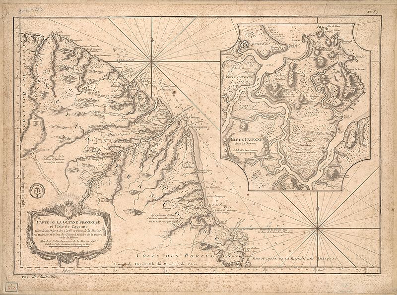
ملف:Carte de la Guyane françoise et l'isle de Cayenne (Bellin, 1763).jpg
اذهب إلى التنقل
اذهب إلى البحث

حجم هذه المعاينة: 800 × 595 بكسل. الأبعاد الأخرى: 320 × 238 بكسل | 640 × 476 بكسل | 1٬024 × 762 بكسل | 1٬267 × 943 بكسل.
الملف الأصلي (1٬267 × 943 بكسل حجم الملف: 1٫08 ميجابايت، نوع MIME: image/jpeg)
| هذا ملف من ويكيميديا كومنز. معلومات من صفحة وصفه مبينة في الأسفل. كومنز مستودع ملفات ميديا ذو رخصة حرة. |
.jpg)
ملخص
| الوصف |
English: This map of French Guiana and the island of Cayenne was made in 1763 by Jacques Bellin (1703-72), a prolific cartographer assigned the Ministry of the French Navy.
Français : Carte de la Guyane françoise et l'isle de Cayenne
Cette carte de la Guyane française et l'île de Cayenne est due à Jacques Bellin (1703-72), un cartographe prolifique affecté au ministère de la Marine française. Elle reflète le soin apporté aux relevés topographiques des baies, des mers et des ports qui caractérisait la cartographie navale française du XVIIIe siècle. En plus d'informations détaillées sur la côte, la carte de Bellin inclut des notes sur l'intérieur de cette partie de l'Amérique du sud, dont l'essentiel restait encore largement inconnu des Européens. |
|||||||||||||||||||
| التاريخ | , Versailles, France | |||||||||||||||||||
| المصدر | Bibliothèque numérique mondiale | |||||||||||||||||||
| المؤلف |
|
|||||||||||||||||||
ترخيص
|
هذا العمل يقع في النَّطاق العامّ في بلد المنشأ وفي البلدان الأخرى والمناطق التي تمتدُّ فيها مدة حقوق التَّأليف والنشر لتغطي زمن حياة المُؤلِّف و 100 سنةً بعد وفاته أو أقل من ذلك. | |
| هذا الملفُّ مَلحُوظُ بصفته غيرَ مُقيَّدٍ بحقوق التَّأليف والنشر، وهذا يشمل أيضاً الحقوق المُجاوِرة أَو ذات الصلة جميعُها. | |
تاريخ الملف
اضغط على زمن/تاريخ لرؤية الملف كما بدا في هذا الزمن.
| زمن/تاريخ | صورة مصغرة | الأبعاد | مستخدم | تعليق | |
|---|---|---|---|---|---|
| حالي | 03:51، 22 أبريل 2009 | | 1٬267 × 943 (1٫08 ميجابايت) | commonswiki>Abalg | {{Information |Description={{en|1=This map of French Guiana and the island of Cayenne was made in 1763 by Jacques Bellin (1703-72), a prolific cartographer assigned the Ministry of the French Navy.}} {{fr|1=Carte de la Guyane françoise et l'isle de Cayen |
استخدام الملف
ال1 ملف التالي مكررات لهذا الملف (المزيد من التفاصيل):
.jpg)
- ملف:Carte de la Guyane françoise et l'isle de Cayenne (Bellin, 1763).jpg من ويكيميديا كومنز
الصفحتان التاليتان تستخدمان هذا الملف:
.jpg)