ملف:Bishop tuff.jpg

من أرابيكا، الموسوعة الحرة
اذهب إلى التنقل اذهب إلى البحث

Bishop_tuff.jpg(800 × 500 بكسل حجم الملف: 139 كيلوبايت، نوع MIME: image/jpeg)

ملخص

الوصف
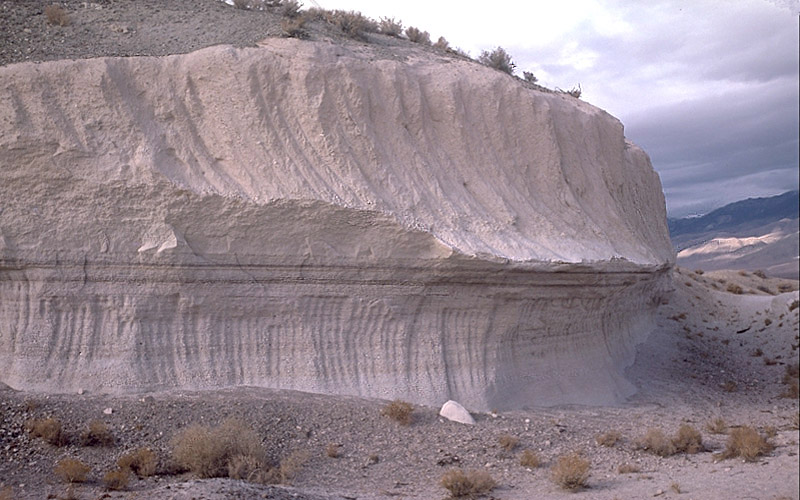
English: Photo showing two layers of Bishop tuff, eastern California, United States.
This outcrop is exposed in a rock quarry in Chalfant Valley about 25 km southeast of Long Valley Caldera. The two main units of the Bishop Tuff deposit are visible here: (1) the lower 5 m of the section consists of the pumice that fell to the ground (airfall pumice) downwind from the eruption; and (2) the upper 5-6 m of the section consists of the basal part of the pyroclastic flows that swept at hurricane speed away from the eruption. The thin dark "layers" just below the contact between the units are stains from an ancient groundwater table (manganese oxide stains).
التاريخ  التقطت في٢٩ أكتوبر ١٩٨٧
المصدر Archived source link
المؤلف Roy A. Bailey

ترخيص

Public domain

Bahasa Indonesia  català  čeština  Deutsch  eesti  English  español  français  galego  italiano  Nederlands  português  polski  sicilianu  suomi  Tiếng Việt  Türkçe  български  македонски  русский  മലയാളം  한국어  日本語  中文  中文(简体)  中文(繁體)  العربية  فارسی  +/−

الشروحات

أضف شرحاً من سطر واحد لما يُمثِّله هذا الملف
Layers of Bishop tuff

العناصر المصورة في هذا الملف

يُصوِّر

Bishop Tuff الإنجليزية

٢٩ أكتوبر 1987

١٤٢٬٠٤٩ بايت

٥٠٠ بكسل

٨٠٠ بكسل

تاريخ الملف

اضغط على زمن/تاريخ لرؤية الملف كما بدا في هذا الزمن.

زمن/تاريخصورة مصغرةالأبعادمستخدمتعليق
حالي08:58، 15 أبريل 2007تصغير للنسخة بتاريخ 08:58، 15 أبريل 2007800 × 500 (139 كيلوبايت)commonswiki>Hike395{{Information |Description = Photo showing two layers of Bishop tuff, eastern California, United States |Source = http://lvo.wr.usgs.gov/gallery/30714277-048_caption.html |Date = 1987-10-29 |Author = Roy A. Bailey |Permission = }} USGS

ال1 ملف التالي مكررات لهذا الملف (المزيد من التفاصيل):

الصفحة التالية تستخدم هذا الملف:

بيانات وصفية