ملف:Bayamon Puerto Rico aerial view.jpg
الملف الأصلي(1٬504 × 1٬050 بكسل حجم الملف: 413 كيلوبايت، نوع MIME: image/jpeg)

الوصف
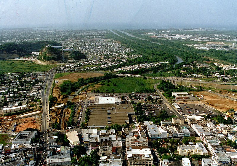
English: Aerial view of Bayamón, Puerto Rico. The U.S. Army Corps of Engineers has constructed a flood control project on the Rio de Bayamón through the city. View is to the north towards the Atlantic Ocean. The Canton Mall is visible in the center of the picture.
Coordinates: 18°24′2.41″N 66°9′26.54″W / 18.4006694°N 66.1573722°W / 18.4006694; -66.1573722
الموقع
InfoField
بايامون
التاريخ (Caveat: Dates provided by U.S. Army Corps of Engineers Digital Visual Library are not reliable and are often wrong.)
المصدر U.S. Army Corps of Engineers Digital Visual Library
Image page
Image description page
Digital Visual Library home page
المؤلف Tony Santana, U.S. Army Corps of Engineers
الترخيص
(إعادة استخدام هذا الملف)
Public domain
This image or file is a work of a U.S. Army Corps of Engineers soldier or employee, taken or made as part of that person's official duties. As a work of the U.S. federal government, the image is in the public domain.

English | italiano | Nederlands | پښتو | русский | sicilianu | slovenščina | Türkçe | українська | +/−

الشروحات

أضف شرحاً من سطر واحد لما يُمثِّله هذا الملف
Aerial view of Bayamón, Puerto Rico

العناصر المصورة في هذا الملف

يُصوِّر

d77a51b9f821a258bc4c9cdf6cb234f8e280eff3

طريقة الاستدلال: SHA-1 الإنجليزية

٤٢٣٬٢٨٥ بايت

١٬٠٥٠ بكسل

١٬٥٠٤ بكسل

تاريخ الملف

اضغط على زمن/تاريخ لرؤية الملف كما بدا في هذا الزمن.

زمن/تاريخصورة مصغرةالأبعادمستخدمتعليق
حالي05:35، 27 أبريل 2007تصغير للنسخة بتاريخ 05:35، 27 أبريل 20071٬504 × 1٬050 (413 كيلوبايت)commonswiki>DanMS{{Information | Description = {{en|Aerial view of Bayamón, Puerto Rico. The U.S. Army Corps of Engineers has constructed a flood control project on the Rio de Bayamón through the city. View is to the north towards the Atlantic Ocean. The Canton Mall

ال1 ملف التالي مكررات لهذا الملف (المزيد من التفاصيل):

لا توجد صفحات تستخدم هذا الملف.