|
تضامنًا مع حق الشعب الفلسطيني |
ملف:Alemannic-Dialects-Map-English.png
اذهب إلى التنقل
اذهب إلى البحث
حجم هذه المعاينة: 800 × 571 بكسل. الأبعاد الأخرى: 320 × 229 بكسل | 640 × 457 بكسل | 1٬024 × 731 بكسل | 1٬400 × 1٬000 بكسل.
الملف الأصلي (1٬400 × 1٬000 بكسل حجم الملف: 838 كيلوبايت، نوع MIME: image/png)
| هذا ملف من ويكيميديا كومنز. معلومات من صفحة وصفه مبينة في الأسفل. كومنز مستودع ملفات ميديا ذو رخصة حرة. |
| الوصف |
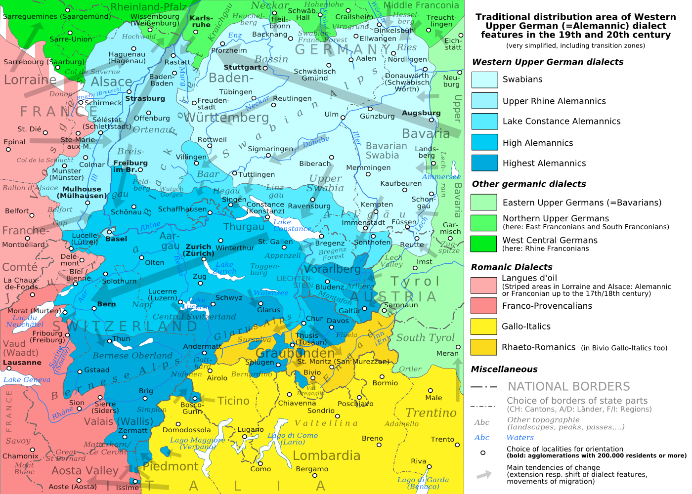
English: The traditional distribution area of the western upper German (=alemannic) dialects in the 19th and 20th century. Source: Mainly these articles in the German wikipedia: * Alemannische Dialekte * Grenzorte des alemannischen Dialektraums * Traditionell rätoromanischsprachiges Gebiet Graubündens and * Sprachen und Dialekte in der Region Elsass, plus the (newer) literature, which is mentioned there. This area, having been quite stable for at least some 300 years up to the 19th century, saw consecutively more or less strong changes by industrialisation, population growth, migrations and political developments. Deutsch: Das traditionelle Verbreitungsgebiet der westoberdeutschen (=alemannischen) Dialekte im 19. und 20. Jahrhundert. Grundlage: vor allem diese Artikel der deutschsprachigen Wikipedia: * Alemannische Dialekte * Grenzorte des alemannischen Dialektraums * Traditionell rätoromanischsprachiges Gebiet Graubündens und * Sprachen und Dialekte in der Region Elsass, sowie die dort jeweils genannte (jüngere) Literatur. Das bis ins 19. Jahrhundert für mindestens etwa 300 Jahre stabile Gebiet erfuhr nachfolgend durch Industrialisierung, Bevölkerungszuwächse und -bewegungen sowie politische Entwicklungen mehr oder weniger starke Änderungen. Français : Le secteur de distribution traditionnel des dialectes allemands supérieurs occidentaux (=alémannique) au 19e et 20e siècle. Source : Principalement ces articles dans le wikipedia allemand : * Alemannische Dialekte * Grenzorte des alemannischen Dialektraums * Traditionell rätoromanischsprachiges Gebiet Graubündens et * Sprachen und Dialekte in der Region Elsass, plus la littérature (plus jeune), qui est mentionnée là. Ce secteur, après avoir été stable jusqu'au 19e siècle pour au moins environ 300 années, scie consécutivement des changements plus ou moins forts par industrialisation, croissance démographique, migrations et développements politiques. Italiano: Area di distribuzione storica delle varianti linguistiche alto-tedesche occidentali(alemanniche) nel diciannovesimo e ventesimo secolo. Fonti: questa mappa si basa prevalentemente sui seguenti articoli in Wikipedia di lingua tedesca: * Alemannische Dialekte * Grenzorte des alemannischen Dialektraums * Traditionell rätoromanischsprachiges Gebiet Graubündens and * Sprachen und Dialekte in der Region Elsass, in aggiunta alla letteratura più recente menzionata in quegli articoli. Questa area, dopo essere rimasta piuttosto stabile per circa trecento anni fino all'inizio del diciannovesimo secolo, ha poi visto trasformazioni di diversa intensità causate dall'industrializzazione, dalla crescita demografica, dai processi migratori e dagli sviluppi politici. |
| التاريخ | (UTC) |
| المصدر | |
| المؤلف |
|
| إصدارات أخرى |
PNG:
PNG:
SVG:
SVG: SVG:
|


| هذا رسمٌ مُعَدَّلٌ رقميَّاً من النسخة الأصليَّة. التعديلات هي: PNG-Version. يُمكن الاطلاع على النسخة الأصليَّة هنا: Alemannic-Dialects-Map-English.svg:
|
أنا، صاحب حقوق التأليف والنشر لهذا العمل، أنشر هذا العمل تحت الرخص التالية:
- يحقُّ لك:
- مشاركة العمل – نسخ العمل وتوزيعه وبثُّه
- إعادة إنتاج العمل – تعديل العمل
- حسب الشروط التالية:
- نسب العمل إلى مُؤَلِّفه – يلزم نسب العمل إلى مُؤَلِّفه بشكل مناسب وتوفير رابط للرخصة وتحديد ما إذا أجريت تغييرات. بالإمكان القيام بذلك بأية طريقة معقولة، ولكن ليس بأية طريقة تشير إلى أن المرخِّص يوافقك على الاستعمال.
- الإلزام بترخيص المُشتقات بالمثل – إذا أعدت إنتاج المواد أو غيرت فيها، فيلزم أن تنشر مساهماتك المُشتقَّة عن الأصل تحت ترخيص الأصل نفسه أو تحت ترخيص مُتوافِقٍ معه.

|
يسمح نسخ وتوزيع و/أو تعديل هذه الوثيقة تحت شروط رخصة جنو للوثائق الحرة، الإصدار 1.2 أو أي إصدار لاحق تنشره مؤسسة البرمجيات الحرة؛ دون أقسام ثابتة ودون نصوص أغلفة أمامية ودون نصوص أغلفة خلفية. نسخة من الرخصة تم تضمينها في القسم المسمى GNU Free Documentation License. |
لك أن تختار الرخصة التي تناسبك.
سجلُّ الرَّفع الأصيل
This image is a derivative work of the following images:
- File:Alemannic-Dialects-Map-English.svg licensed with Cc-by-sa-3.0,2.5,2.0,1.0, GFDL
- 2010-08-11T20:11:45Z Testtube 1400x1000 (482460 Bytes) Bugfix
- 2010-08-11T19:44:48Z Testtube 1400x1000 (482811 Bytes) Bugfix
- 2010-08-11T15:14:04Z Testtube 1400x1000 (482540 Bytes) {{Information |Description={{en|1=The traditional distribution area of the western upper german (=alemannic) dialects in the 19th and 20th century. Source: Mainly these articles in the german wikipedia: * [http://de.wikipedi
Uploaded with derivativeFX
تاريخ الملف
اضغط على زمن/تاريخ لرؤية الملف كما بدا في هذا الزمن.
| زمن/تاريخ | صورة مصغرة | الأبعاد | مستخدم | تعليق | |
|---|---|---|---|---|---|
| حالي | 21:01، 19 أغسطس 2010 | | 1٬400 × 1٬000 (838 كيلوبايت) | commonswiki>Testtube~commonswiki | Bugfix. |
استخدام الملف
ال1 ملف التالي مكررات لهذا الملف (المزيد من التفاصيل):
- ملف:Alemannic-Dialects-Map-English.png من ويكيميديا كومنز
لا توجد صفحات تستخدم هذا الملف.