|
تضامنًا مع حق الشعب الفلسطيني |
ملف:ASPA-126-Byers-Peninsula.png
اذهب إلى التنقل
اذهب إلى البحث

حجم هذه المعاينة: 800 × 562 بكسل. الأبعاد الأخرى: 320 × 225 بكسل | 640 × 450 بكسل | 1٬024 × 719 بكسل | 1٬280 × 899 بكسل | 1٬848 × 1٬298 بكسل.
الملف الأصلي (1٬848 × 1٬298 بكسل حجم الملف: 1٫23 ميجابايت، نوع MIME: image/png)
| هذا ملف من ويكيميديا كومنز. معلومات من صفحة وصفه مبينة في الأسفل. كومنز مستودع ملفات ميديا ذو رخصة حرة. |
ملخص
| الوصف |
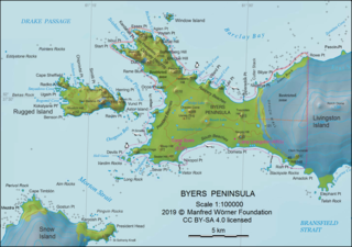
English: L.L. Ivanov. Antarctia: Byers Peninsula. Scale 1:100000 topographic map. Manfred Wörner Foundation, 2019. Revised and updated version of the relevant fragment of the author’s 2010 map of Livingston Island and Greenwich, Robert, Snow and Smith Islands. |
| التاريخ | |
| المصدر | عمل شخصي |
| المؤلف | Apcbg |
| إصدارات أخرى | Fragment of the Commons file File:Livingston-Island-Map-2010.jpg |
| موقع آلة التصوير | | هذه وغيرها من الصور في مواقعها على: خريطة الشارع المفتوحة |
|---|
ترخيص
أنا، صاحب حقوق التأليف والنشر لهذا العمل، أنشر هذا العمل تحت الرخصة التالية:
هذا الملفُّ مُرخَّصٌ برخصة المشاع الإبداعي الدَّوليَّة المُلزِمة بنسب العمل إلى مُؤَلِّفه وبترخيص المُشتقَّات بالمثل 4.0.
- يحقُّ لك:
- مشاركة العمل – نسخ العمل وتوزيعه وبثُّه
- إعادة إنتاج العمل – تعديل العمل
- حسب الشروط التالية:
- نسب العمل إلى مُؤَلِّفه – يلزم نسب العمل إلى مُؤَلِّفه بشكل مناسب وتوفير رابط للرخصة وتحديد ما إذا أجريت تغييرات. بالإمكان القيام بذلك بأية طريقة معقولة، ولكن ليس بأية طريقة تشير إلى أن المرخِّص يوافقك على الاستعمال.
- الإلزام بترخيص المُشتقات بالمثل – إذا أعدت إنتاج المواد أو غيرت فيها، فيلزم أن تنشر مساهماتك المُشتقَّة عن الأصل تحت ترخيص الأصل نفسه أو تحت ترخيص مُتوافِقٍ معه.
Published by the Manfred Wörner Foundation, and hereby released by the Foundation’s President and CEO Apcbg (Lyubomir Ivanov) for publication under the Creative Commons Attribution ShareAlike 4.0 license.
تاريخ الملف
اضغط على زمن/تاريخ لرؤية الملف كما بدا في هذا الزمن.
| زمن/تاريخ | صورة مصغرة | الأبعاد | مستخدم | تعليق | |
|---|---|---|---|---|---|
| حالي | 16:14، 13 فبراير 2019 | | 1٬848 × 1٬298 (1٫23 ميجابايت) | commonswiki>Apcbg | Minor |
استخدام الملف
ال1 ملف التالي مكررات لهذا الملف (المزيد من التفاصيل):
- ملف:ASPA-126-Byers-Peninsula.png من ويكيميديا كومنز
الصفحة التالية تستخدم هذا الملف: