|
تضامنًا مع حق الشعب الفلسطيني |
ملف:20170807 Bolivia 1373 crop Potosí sRGB (37270469644).jpg
الملف الأصلي (2٬700 × 3٬599 بكسل حجم الملف: 1٫61 ميجابايت، نوع MIME: image/jpeg)
| هذا ملف من ويكيميديا كومنز. معلومات من صفحة وصفه مبينة في الأسفل. كومنز مستودع ملفات ميديا ذو رخصة حرة. |
.jpg)
ملخص
| الوصف |
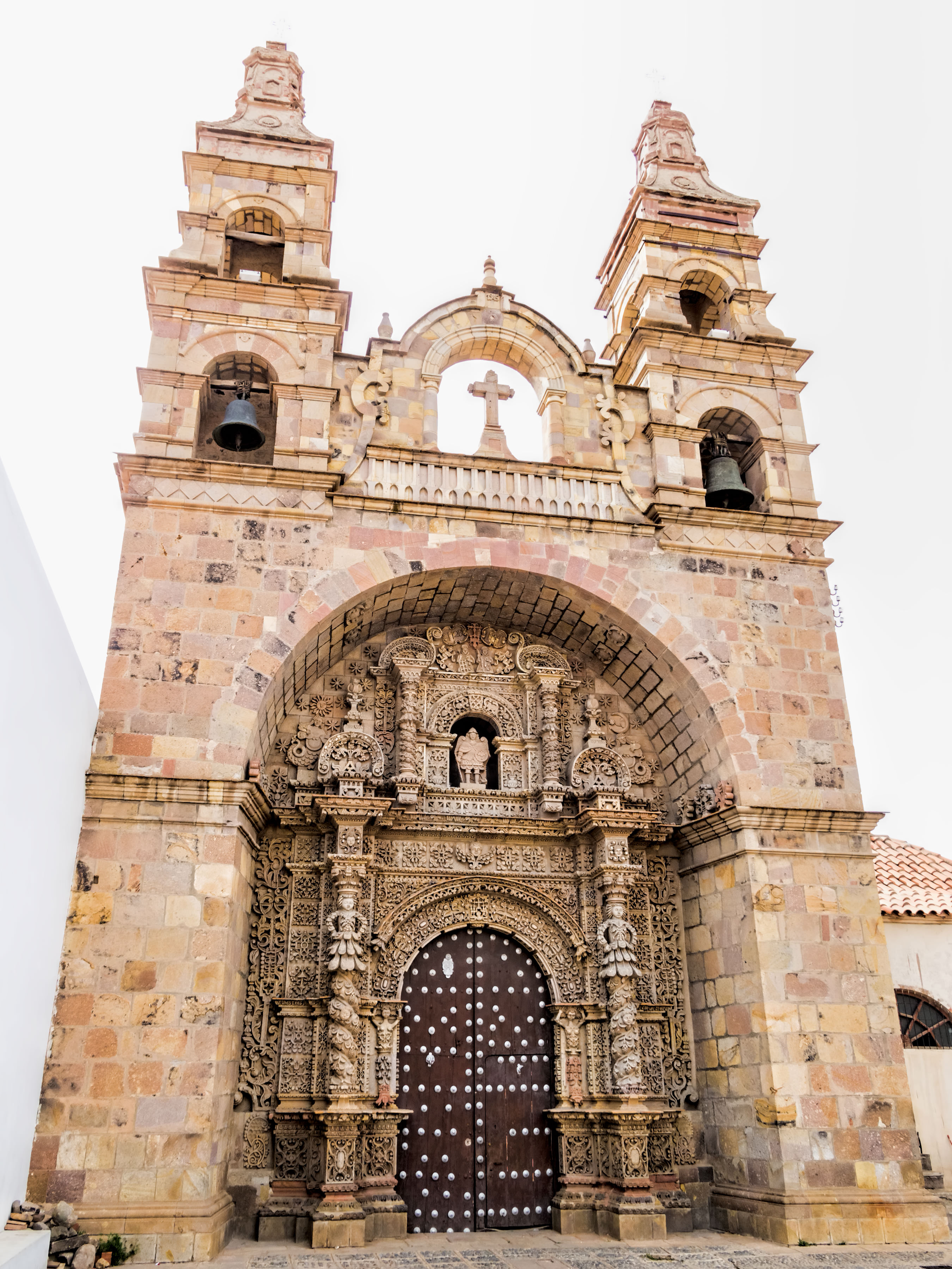
The Church of St. Lawrence of Carangas was built by indigenous people from Carangas, Bolivia, to be their parish church. They had been brought to Potosí to be forced laborers in the silver mine. Construction began in 1548. The church boasts an ornate entrance portal carved in stone by indigenous artisans in a mestizo baroque style. The bell towers were added during extensive remodeling from 1728 to 1744. A renovation was done in 1987. Potosí (elev. 4,090m/13,420ft) [for comparison: Lhasa, Tibet, at 3,658m/12,001ft] was founded in 1545 as a mining town at the foot of Rich Hill (Cerro Rico), the world’s largest silver deposit. An estimated 60% of all silver mined in the world during the second half of the 16th century came from Potosí which was reputed to be the world’s largest industrial complex at the time. Its population eventually exceeded 200,000 people, making it one of the largest cities in the world. Most of the mining and smelting (using mercury) was done by forced labor, both indigenous people and African slaves. As many as 8 million workers are estimated to have died between 1545 and 1825. Output began to decline in the early 19th century. By the 1890s, low silver prices prompted a shift to mining tin. Growing demand for tin this century by the electronics industry has helped the local economy. Silver extraction continues on a small scale. Miguel de Cervantes’ novel “Don Quixote” describes Potosí as a land of “extraordinary richness” (chapter 71 in the second volume which was published in 1615). The City of Potosí was declared a UNESCO World Heritage Site in 1987. On Google Earth: Iglesia de San Lorenzo de Carangas 19°35'12.12"S, 65°45'17.50"W |
| التاريخ | |
| المصدر | 20170807_Bolivia_1373 crop Potosí sRGB |
| المؤلف | Dan Lundberg |
| موقع الكاميرا | | هذه وغيرها من الصور في مواقعها على: خريطة الشارع المفتوحة |
|---|
.jpg¶ms=-19.586936_N_-065.754826_E_globe:Earth_type:camera_source:Flickr_&language=ar)
ترخيص
- يحقُّ لك:
- مشاركة العمل – نسخ العمل وتوزيعه وبثُّه
- إعادة إنتاج العمل – تعديل العمل
- حسب الشروط التالية:
- نسب العمل إلى مُؤَلِّفه – يلزم نسب العمل إلى مُؤَلِّفه بشكل مناسب وتوفير رابط للرخصة وتحديد ما إذا أجريت تغييرات. بالإمكان القيام بذلك بأية طريقة معقولة، ولكن ليس بأية طريقة تشير إلى أن المرخِّص يوافقك على الاستعمال.
- الإلزام بترخيص المُشتقات بالمثل – إذا أعدت إنتاج المواد أو غيرت فيها، فيلزم أن تنشر مساهماتك المُشتقَّة عن الأصل تحت ترخيص الأصل نفسه أو تحت ترخيص مُتوافِقٍ معه.
| نَشَر Dan Lundberg هذه الصُّورة على موقع فلِيكر بتاريخ https://flickr.com/photos/9508280@N07/37270469644 (أَرشيف). ورَاجَعها FlickreviewR 2 في ٢ نوفمبر ٢٠١٧، وتأكَّدَ أَنَّها مُرخَّصة برخصة cc-by-sa-2.0. |
تاريخ الملف
اضغط على زمن/تاريخ لرؤية الملف كما بدا في هذا الزمن.
| زمن/تاريخ | صورة مصغرة | الأبعاد | مستخدم | تعليق | |
|---|---|---|---|---|---|
| حالي | 19:58، 2 نوفمبر 2017 | | 2٬700 × 3٬599 (1٫61 ميجابايت) | commonswiki>Ser Amantio di Nicolao | Transferred from Flickr via Flickr2Commons |
استخدام الملف
ال1 ملف التالي مكررات لهذا الملف (المزيد من التفاصيل):
.jpg)
- ملف:20170807 Bolivia 1373 crop Potosí sRGB (37270469644).jpg من ويكيميديا كومنز
الصفحتان التاليتان تستخدمان هذا الملف:
.jpg)