|
تضامنًا مع حق الشعب الفلسطيني |
ملف:20170805 Bolivia 1214 Sucre sRGB (26204168039).jpg

الملف الأصلي (3٬648 × 2٬736 بكسل حجم الملف: 2٫16 ميجابايت، نوع MIME: image/jpeg)
| هذا ملف من ويكيميديا كومنز. معلومات من صفحة وصفه مبينة في الأسفل. كومنز مستودع ملفات ميديا ذو رخصة حرة. |
.jpg)
ملخص
| الوصف |
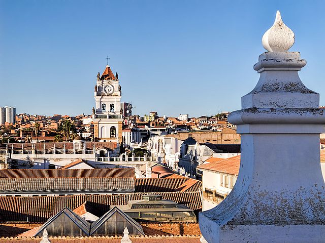
The roof of the Convent of St. Felipe Neri (built in the 17th century and now a museum) provides a panoramic view of the rooftops of Sucre. The tower with the clock in the distance is the bell tower for the Metropolitan Cathedral of Sucre (built between 1559 and 1712 with the clock brought over from London in 1722). Sucre is known as “The White City” because most of the buildings are painted white—and usually have a roof of terracotta tiles. Sucre (elev. 2,810m/9,214ft) was founded by the Spanish in 1538 as Ciudad de la Plata de la Nueva Toledo (Silver City of New Toledo). It became the judicial, religious, and cultural center of the region. Bolivia achieved independence from Spain on 6 August 1825, the last country in Latin America to do so. In 1839 the city was declared the capital of Bolivia and renamed in honor of Antonio José de Sucre (1795-1830), a leader of the fight for independence who was a close friend of Simón Bolívar and served as the second president of Bolivia from the end of 1825 to 1828. (The administrative capital of Bolivia shifted to La Paz in 1898.) The Historic City of Sucre was declared a UNESCO World Heritage Site in 1991. On Google Earth: Convento de San Felipe Neri 19° 3'0.53"S, 65°15'39.91"W Catedral Metropolitana 19° 2'55.48"S, 65°15'35.81"W |
| التاريخ | |
| المصدر | 20170805_Bolivia_1214 Sucre sRGB |
| المؤلف | Dan Lundberg |
| موقع الكاميرا | | هذه وغيرها من الصور في مواقعها على: خريطة الشارع المفتوحة |
|---|
.jpg¶ms=-19.049284_N_-065.260462_E_globe:Earth_type:camera_source:Flickr_&language=ar)
ترخيص
- يحقُّ لك:
- مشاركة العمل – نسخ العمل وتوزيعه وبثُّه
- إعادة إنتاج العمل – تعديل العمل
- حسب الشروط التالية:
- نسب العمل إلى مُؤَلِّفه – يلزم نسب العمل إلى مُؤَلِّفه بشكل مناسب وتوفير رابط للرخصة وتحديد ما إذا أجريت تغييرات. بالإمكان القيام بذلك بأية طريقة معقولة، ولكن ليس بأية طريقة تشير إلى أن المرخِّص يوافقك على الاستعمال.
- الإلزام بترخيص المُشتقات بالمثل – إذا أعدت إنتاج المواد أو غيرت فيها، فيلزم أن تنشر مساهماتك المُشتقَّة عن الأصل تحت ترخيص الأصل نفسه أو تحت ترخيص مُتوافِقٍ معه.
| نَشَر Dan Lundberg هذه الصُّورة على موقع فلِيكر بتاريخ https://flickr.com/photos/9508280@N07/26204168039 (أَرشيف). ورَاجَعها FlickreviewR 2 في ٢ نوفمبر ٢٠١٧، وتأكَّدَ أَنَّها مُرخَّصة برخصة cc-by-sa-2.0. |
تاريخ الملف
اضغط على زمن/تاريخ لرؤية الملف كما بدا في هذا الزمن.
| زمن/تاريخ | صورة مصغرة | الأبعاد | مستخدم | تعليق | |
|---|---|---|---|---|---|
| حالي | 19:58، 2 نوفمبر 2017 | | 3٬648 × 2٬736 (2٫16 ميجابايت) | commonswiki>Ser Amantio di Nicolao | Transferred from Flickr via Flickr2Commons |
استخدام الملف
ال1 ملف التالي مكررات لهذا الملف (المزيد من التفاصيل):
.jpg)
- ملف:20170805 Bolivia 1214 Sucre sRGB (26204168039).jpg من ويكيميديا كومنز
الصفحة التالية تستخدم هذا الملف:
.jpg)