ملف:Mediterranean Sea political map-fr.svg
من أرابيكا، الموسوعة العربية الحرة
المزيد من الإجراءات

حجم معاينة PNG لذلك الملف ذي الامتداد SVG: 800 × 585 بكسل. الأبعاد الأخرى: 320 × 234 بكسل | 640 × 468 بكسل | 1٬024 × 749 بكسل | 1٬280 × 936 بكسل | 2٬560 × 1٬872 بكسل | 2٬046 × 1٬496 بكسل.
الملف الأصلي (ملف SVG، أبعاده 2٬046 × 1٬496 بكسل، حجم الملف: 1٫09 ميجابايت)
| هذا ملف من ويكيميديا كومنز. معلومات من صفحة وصفه مبينة في الأسفل. كومنز مستودع ملفات ميديا ذو رخصة حرة. |
ملخص
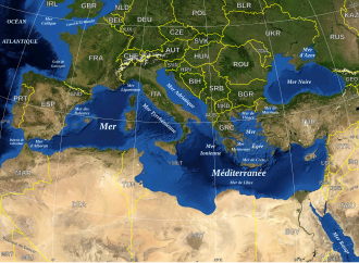
| الوصف |
English: Map in French of the Mediterranean Sea, with the borders and the name of the States (except Montenegro, missing) following the ISO 3166-1 Alpha-3 code.
Français : Carte en français de la Mer Méditerranée avec les frontières et les noms des États (manque le Monténégro) suivant le code ISO 3166-1 Alpha-3.
Español: Mapa en francés del Mar Mediterráneo con las fronteras y los códigos de los Estados (menos el Montenegro) segun la norma ISO 3166-1 Alpha-3.
Deutsch: Karte des Mittelmeer, mit Staaten (bis auf Montenegro), ISO 3166-1 Alpha-3 code, und Grenzen, in französisch. |
| التاريخ | |
| المصدر |
Own work ; Raster background map : screenshot from NASA World Wind (Public Domain) |
| المؤلف | Eric Gaba (Sting - fr:Sting) |
| الترخيص (إعادة استخدام هذا الملف) |
All rights released |
| إصدارات أخرى |
[]
|
| SVG منشأ الملف |


| يحتوي الملفُّ الشُّعاعي هذا على نصٍّ مُضمَّن يُمكِن ترجمته إِلى العربيَّة باستخدام مُحرر صور شعاعيَّةٍ أو مُحررٍ نصِّيٍّ، لمزيدٍ من المعلومات، راجع: هذه الصَّفحة. |
ترخيص
| هذه الصُّورة في النِّطاق العامِّ لأنها لقطة شاشةٍ مِن تطبيق وُرد ويند الخاصِّ بوكالة الفضاء الأمريكيَّة مأخوذةٌ مِن نمطٍ يَستعمل طَبقةً مَوجُودةً في النِّطاق العامِّ أساساً.
|
 |
| This work was previously under Public Domain, or a Free License. It has been digitally enhanced and/or modified. This derivative work has been (or is hereby) released into the public domain by its author, Sting at the French Wikipedia project. This applies worldwide. In some countries this is not legally possible; if so:
|
تاريخ الملف
اضغط على زمن/تاريخ لرؤية الملف كما بدا في هذا الزمن.
| زمن/تاريخ | صورة مصغرة | الأبعاد | مستخدم | تعليق | |
|---|---|---|---|---|---|
| حالي | 01:59، 13 فبراير 2026 | | 2٬046 × 1٬496 (1٫09 ميجابايت) | wikimediacommons>Sting | Added MNE, XK ; Added Gibraltar, Ceuta, Melilla borders |
استخدام الملف
الصفحة التالية تستخدم هذا الملف: